The most memorable tornado during the week of May 15-21, 2016. This also serves as the chasecation 2016 day 3 recap.
There’s a reason for tweets like this.
Even sans tornadoes, Kansas is a beautiful place, but it’s also where we’ve tended to pile up numbers during our chasecations. In four out of six years I’ve snagged a tornado in the state. One year (2014) we didn’t make it to Kansas, and one year (2011) we went during a historic low of activity.
Day three of chasecation 2016 was our first “real” chase day. There were plenty of questions about what would happen, mostly thanks to marginal mid-level wind speeds helping to vent any storms, but there was also fairly high likelihood of supercells. Pretty much every model over the days prior spit some out. And it was likely the first of a string of chase days.
We started the morning off in Colby, Kansas. It was cool and foggy north of the effective warm front. That’s a fairly typical start to many quality chase days if you’re coming in from the north.
We drove until we found good sunshine, then made a beeline for the area it seemed the best ingredients of the day were bound to line up. This was to the east of the dry line hugging the Kansas/Colorado border, and near the tip of the best CAPE (convective energy).
Temperatures east of the dry line headed into the 80s as dew points surged into the low-and-mid 60s. Directional shear was quite good despite the meager mid-level winds. Surface winds cranked all day though, and during peak season in Kansas it doesn’t take a whole lot to get something amazing.
Given the expected small number of storms in the area, we were certainly not alone when it comes to chasers. Still, we were likely the first or among the first to arrive in Leoti, Kansas. Arriving before lunch, we wandered a bit, had some lunch, then went a little south of town to watch things bubble.
We waited.
Watching wheat in the wind is oddly enjoyable. #thesimplethings pic.twitter.com/tStAjiOJif
— Ian Livingston (@islivingston) May 21, 2016
And waited.
This day is very Rozel so far. Wait wait wait get bored. See a million chasers at the gas station. Next… ? 😉 pic.twitter.com/XF3Pj0TVaa
— Ian Livingston (@islivingston) May 21, 2016
Then it happened.
Here’s what the supercell complex which ultimately became one dominant cell looked like from space:
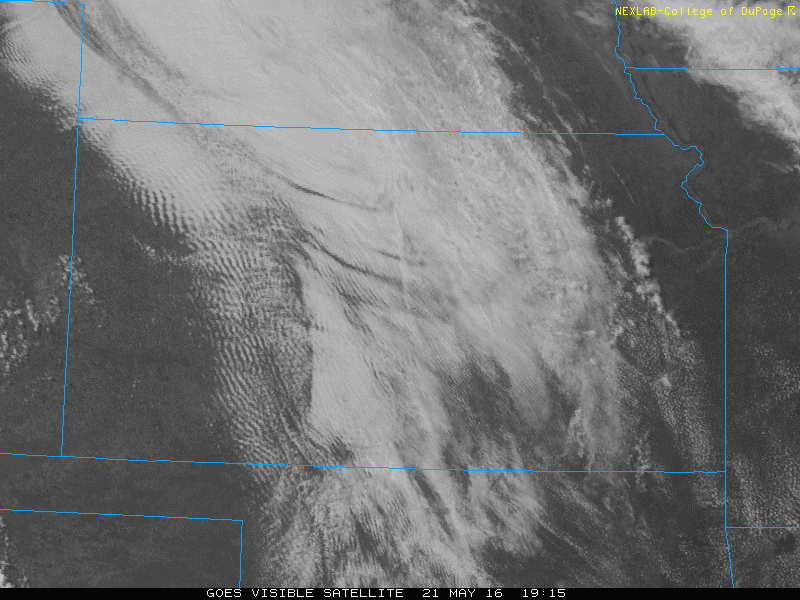
And the radar loop:
Leoti, KS supercell cluster and the eventual dominant cell that rooted on the warm front. pic.twitter.com/CKGN9kSTCz
— Ian Livingston (@islivingston) May 22, 2016
Several tornadoes were reported from this storm. We only saw one ourselves. All were fairly brief and likely rather weak.
Tornado north of Leoti Ks pic.twitter.com/mFqzemlJdA
— Ian Livingston (@islivingston) May 22, 2016
The 2nd Leoti KS tornado we @SimonStormRider got today (05/21/2016). @JimCantore @SarahDillingham @ErinNMcGarry pic.twitter.com/vsravXp1Cw
— Juston Drake (@JustonStrmRider) May 22, 2016
Leoti, KS tornado with wrapping rain curtains from yesterday #kswx pic.twitter.com/L3xfyIi6SE
— Stas (@StasIsChasing) May 22, 2016
While tornadoes are often the hope in a storm chase, supercell structure can truly blow you away. The Leoti, Kansas storm was among the prettiest I’ve seen in my six years of chasecationing. Everyone seemed pretty floored by its beauty!
What. A. Storm. #kswx pic.twitter.com/Yrws2jkf26
— Ryan ☈ogers (@wxryanrogers) May 22, 2016
Great structure on this storm north of Leoti, KS. #kswx @NWSGoodland pic.twitter.com/i7RHod0Zoc
— Grady Dixon (@pgradydixon) May 22, 2016
Latest posts by Ian Livingston (see all)
- Top tornado videos of 2023 - January 1, 2024
- March 31, 2023 tornado outbreak videos - March 31, 2023
- Top tornado videos of 2022 - December 31, 2022