1-3 DAY
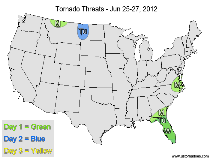
Monday
Southern Southeast — POTENTIAL: High — CONFIDENCE: Normal
Storms initiated by Tropical Storm Debby will be in a high shear/low CAPE environment capable of producing mostly brief tornadoes.
Southern Mid-Atlantic, North Carolina — POTENTIAL: Very Low — CONFIDENCE: Normal
Storms forming along and ahead of a cold front will have moderate CAPE and moderate shear to organize storms, but mostly unidirectional wind flow and downsloping winds will hinder tornadic development.
Montana — POTENTIAL: Very Low — CONFIDENCE: High
Storms forming in the vicinity of an upper-level low may gain enough rotation to become tornadic within a low to moderate CAPE and moderate to high shear environment.
Tuesday
Florida — POTENTIAL: Medium — CONFIDENCE: Normal
Tropical Storm Debby is forecast to remain just offshore, allowing for tornadic activity to continue in Florida.
Northern High Plains — POTENTIAL: Low — CONFIDENCE: Normal
A strong pocket of upper-level energy will eject out of the main trough, allowing for tornadic development. However, most of the activity is expected to stay north of the border, with a more limited threat to the U.S.
Wednesday
Florida — POTENTIAL: Medium — CONFIDENCE: Normal
Tropical Storm Debby remains a threat for potential tornadoes.
4-7 DAY
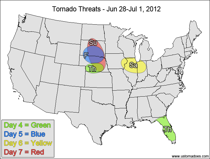
Thursday
Nebraska — POTENTIAL: Low — CONFIDENCE: Normal
Storms forming south of a frontal boundary will be in a moderate/high CAPE and generally low shear environment, with enough low-level directional shear for storms to potentially become tornadic.
Florida — POTENTIAL: Medium — CONFIDENCE: Normal
Tropical Storm Debby remains a threat for potential tornadoes if it stays west or just over Florida.
Friday
South Dakota, Nebraska — POTENTIAL: Low — CONFIDENCE: Normal
Another round of storms is expected in a similar setup to Thursday, though the overall shear profile seems slightly more favorable on Friday.
Saturday
Western Midwest — POTENTIAL: Low — CONFIDENCE: Normal
The same environment that is forecast over Nebraska and South Dakota on Friday will translate eastward into the western Midwest on Saturday.
Sunday
Northern Plains — POTENTIAL: Medium — CONFIDENCE: Low
A short-wave trough is forecast to move into the northern Plains, which could trigger tornadic storms in a high CAPE and low to moderately-sheared environment.
Latest posts by Mark Ellinwood (see all)
- Spring 2023 seasonal tornado outlook - March 1, 2023
- Spring 2022 seasonal tornado outlook - March 1, 2022
- Spring 2021 seasonal tornado outlook - March 1, 2021