What’s this? Chaseable storms?!? Well gee golly gosh! Not much of a setup to look at, but it’s better than nothing.
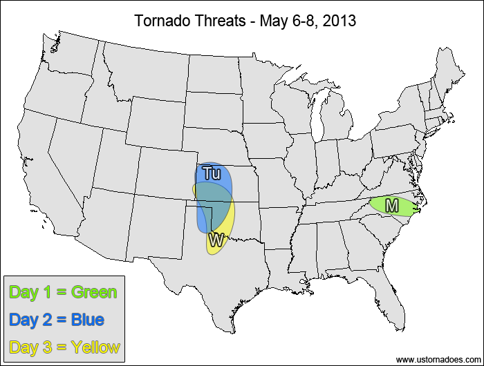
1-3 DAY
North Carolina — POTENTIAL: Very Low — CONFIDENCE: Normal
A narrow corridor of 500-1500 J/kg CAPE has developed with favorable low- and mid-level lapse rates, with enough directional shear for a tornado this afternoon/evening with the isolated cells that are developing.
Tuesday
Central High Plains — POTENTIAL: Very Low — CONFIDENCE: Normal
Moisture will be very limited and LCLs will be high at least initially as a lee trough sets up over the High Plains. However, favorable shear could allow storms that form to rotate and possibly put down a tornado despite the high cloud bases.
Wednesday
Central High Plains— POTENTIAL: Medium — CONFIDENCE: Normal
Stronger lee troughing and better moisture is expected on Wednesday as CAPE jumps into moderate to high territory during the afternoon and early evening, increasing the potential for tornadoes. Weak speed shear aloft along with fairly isolated warm sector storm coverage will keep the overall potential limited.
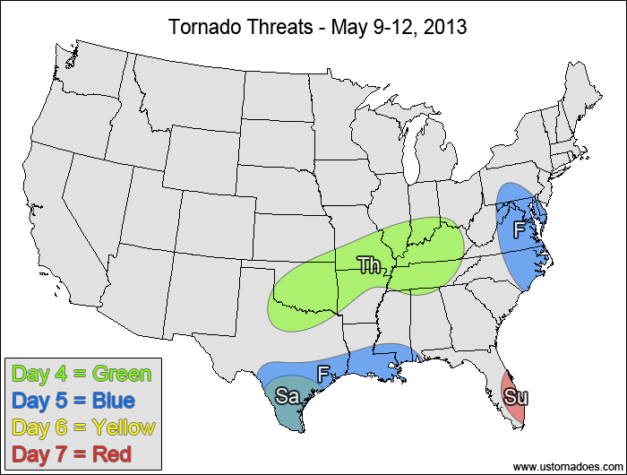
4-7 DAY
Oklahoma, northern Texas, southern Midwest — POTENTIAL: Low — CONFIDENCE: Normal
Speed shear will be weak within the risk area, but enough directional shear is present in an area with moderate CAPE that a tornado or two will be possible.
Friday
Western Gulf — POTENTIAL: Medium — CONFIDENCE: Normal
Southern Texas will have moderate shear and moderate to high CAPE available for storms to rotate and possibly become tornadic. The threat will extend eastward into far southwestern Alabama, but shear and instability become less favorable the farther east you are in the risk area.
Mid-Atlantic, eastern North Carolina — POTENTIAL: Very Low — CONFIDENCE: Low
Shear will be very weak, but the directional shear in conjunction with low to moderate CAPE may be enough for a brief tornado.
Saturday
Southern Texas — POTENTIAL: Low — CONFIDENCE: Normal
Despite weak winds in the low levels, enough shear in the upper levels along with moderate CAPE will keep the threat for a tornado or two around in southern Texas.
Sunday
Southeastern Florida — POTENTIAL: Very Low — CONFIDENCE: Normal
The sea breeze could allow for enough rotation for a brief tornado as storms form in the afternoon, but speed shear and CAPE are expected on the low side.
{ "@context": "https://schema.org", "@type": "Article", "mainEntityOfPage": { "@type": "WebPage", "@id": "https://ustornadoes.com/2026/07/30/claiming-mega-wins-free-spins-deals-for-uk-players/" }, "headline": "Claiming Mega…
Getting Started with Daytonaspin: A Guide for UK Players For players in the United Kingdom…
{ "@context": "https://schema.org", "@type": "Article", "mainEntityOfPage": { "@type": "WebPage", "@id": "https://ustornadoes.com/2026/07/30/pink-lady-casino-registration-in-the-united-kingdom-guide/" }, "headline": "Pink Lady…
Understanding Your Payment Options at Extreme Spins Navigating the financial landscape of an online casino…
Understanding the MySpins Welcome Bonus in the United Kingdom For players in the United Kingdom,…
It's peak tornado season. We briefly examine the top outbreaks from April-June.