The tornado threat in the U.S. peaks today as a disturbance lifts into the Midwest. Another storm system develops in the Plains on Saturday into Sunday and works its way to the East Coast by mid-week. While the tornado risk areas are quite large, the expected number of tornadoes after today is fairly low. There is a fair amount of uncertainty with how the pattern progresses with respect to timing the storm progression and the tornado potential for Sunday onward.
1-3 Day
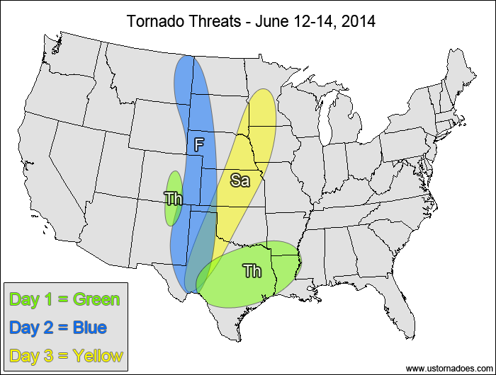
Thursday
Eastern Plains, western Midwest — TORNADO RANGE: 4-12 — CONFIDENCE: Normal
Expected Tornado Hotspot: Western Midwest
Pros: Good speed shear, decent/good directional shear, good upper-level forcing, low to moderate instability
Cons: Widespread cloud cover and “crapvection” in a large portion of the warm sector, questionable storm mode in some areas
Friday
Mid/southern Mississippi Valley, Tennessee Valley, northern Mid-Atlantic — TORNADO RANGE: 3-8 — CONFIDENCE: Normal
Expected Tornado Hotspot: None
Pros: Decent/good directional and speed shear, moderate instability, decent upper-level forcing
Cons: Questionable storm mode, widespread clouds and rain ongoing in the warm sector hindering new storm development
Saturday
East-central Plains, mid-Mississippi Valley — TORNADO RANGE: 2-6 — CONFIDENCE: Normal
Expected Tornado Hotspot: Mid-Mississippi Valley
Pros: Decent/good directional and speed shear, moderate to high instability
Cons: Speed shear in the lower levels is a bit weak, no notable upper-level forcing present, capping/storm coverage concerns
4-7 Day
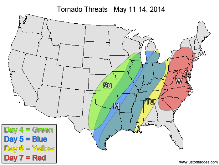
Sunday
Central and southern Plains, western Midwest — TORNADO RANGE: 2-8 — CONFIDENCE: Low
Expected Tornado Hotspot: Mid-Mississippi Valley
Pros: Good speed shear, decent/good directional shear in the northern areas, moderate to high instability, decent/good upper-level forcing
Cons: Storms could line out quickly, cold front could undercut storms, poor/okay directional shear in the southern areas
Monday
Southern Plains, mid-southern Mississippi Valley, Midwest — TORNADO RANGE: 1-4 — CONFIDENCE: Low
Expected Tornado Hotspot: None
Pros: Decent/good speed shear, good forcing, low to moderate instability
Cons: Poor/okay directional shear, unidirectional flow aloft, mostly linear storm mode
Tuesday
ArkLaTex, Midwest, Tennessee Valley — TORNADO RANGE: 1-4 — CONFIDENCE: Low
Expected Tornado Hotspot: None
Pros: Good forcing, low to moderate instability
Cons: Poor/okay directional shear, okay speed shear, unidirectional flow aloft, mostly linear storm mode
Wednesday
Mid-Atlantic, Carolinas — TORNADO RANGE: 0-3 — CONFIDENCE: Low
Expected Tornado Hotspot: None
Pros: Good forcing, low to moderate instability
Cons: Poor/okay directional shear, okay speed shear, unidirectional flow aloft, mostly linear storm mode
Latest posts by Mark Ellinwood (see all)
- Spring 2023 seasonal tornado outlook - March 1, 2023
- Spring 2022 seasonal tornado outlook - March 1, 2022
- Spring 2021 seasonal tornado outlook - March 1, 2021