This is part one of a six part series on tornado outbreak sequences.
Through the years when modern tornado records have been kept, or where historians have dug up old newspapers, microfilm and other forms of media to develop a record of tornadoes back even into the 1600s, there have been numerous documented tornado outbreaks that have left scars on the United States.
These events have included the highly anonymous and appropriately named “Enigma” outbreak of February 19-20, 1884 and the two titanically-scaled “super” outbreaks in 1974 and 2011. And of course one can’t forget the catastrophic Tri-State Tornado event of March 18, 1925, which resulted in the deadliest tornado yet to be recorded on U.S. soil. These are some of the benchmarks that many severe weather connoisseurs look into when trying to establish an idea of “just how bad can it get?”
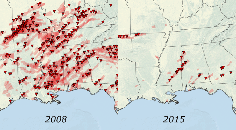
While these events are obviously historic and venerable in their own ways, there exists another, even more anomalous phenomena that basically manifests itself as a barrage of tornadoes over an extended period of time (usually around a week or more), with little to no break in between the salvos. These events can impact vast areas of the United States that would be virtually impossible to hit with a single-system tornado outbreak. Known as tornado outbreak sequences, these events are often responsible for a large percentage of the significant (F/EF2+) tornado occurrences in a given year when they do occur, which also means they can result in immense monetary losses and a high number of casualties.
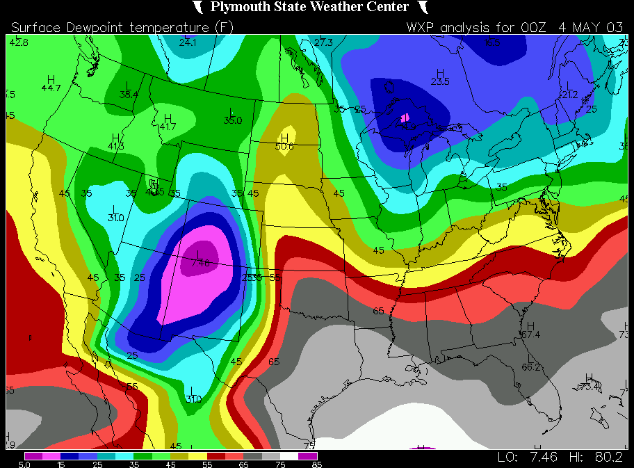
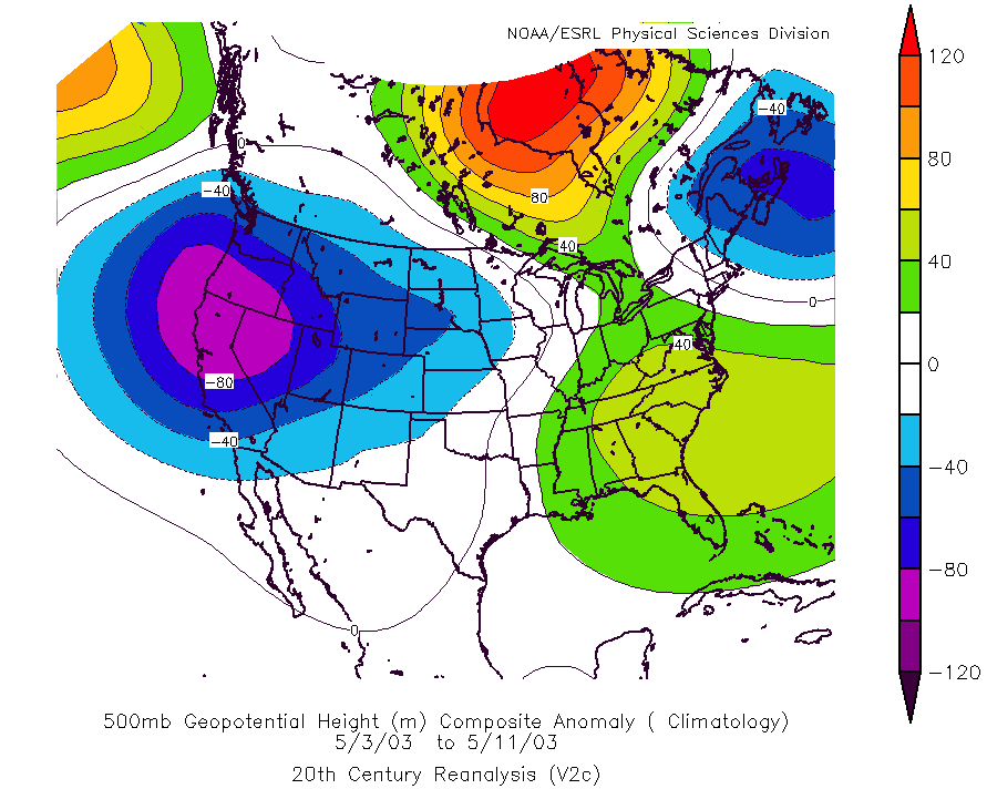
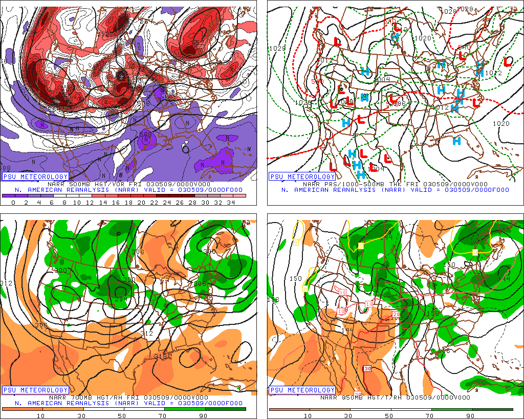
This is the first post in a series of articles on outbreak sequences. It will establish a meteorological blueprint of what typically occurs to set up a tornado outbreak sequence. We’ll then progress to more closely examining five historical cases (5/1896, 5-6/1917, 5/1930, 5/2003 and 5/2008) and their effects.
The rarity of tornado outbreak sequences, usually only happening once or twice per decade (if that), should indicate right away that there are generally very specific meteorological variables that need to be in place for one to occur.
For starters, like all tornado outbreaks, sequences need a source of rich Gulf of Mexico and/or Caribbean moisture in the low levels. Unlike single-system tornado outbreaks, however, outbreak sequences need the main source of moisture to remain uninhibited across a long duration. This means that there can effectively be no significant frontal passages through the Gulf of Mexico during their time-span.
What this suggests is that tornado outbreak sequences are usually not generated by highly meridional (oriented north-south) upper level disturbances that make it east of the Plains. This would mean a frontal intrusion into the Gulf and thus the continental United States would get cut off from the deep moisture source.
However, a meridional synoptic scale system can generate such events if it generally stays west of the Plains, as we’ll see later in two of the case studies.
In addition to a persistent and often widespread reservoir of deep moisture, a stubborn low-pressure troughing pattern over the western United States is needed. This usually (but not always) is accompanied by a high pressure ridge over the eastern United States. What usually follows is a series of shortwave trough ejections around the base of the larger-scale western troughing and across the Continental Divide, generating repeated lee-side cyclogeneses (i.e., development of surface low pressure east of the Rockies).
These low pressure systems then shift eastward/northeastward along with their parent mid-level shortwave disturbances. This provides the mechanism for further poleward moisture movement, and therefore strong instability (CAPE) when blended with cooling temperatures aloft in the vicinity of the upper level trough.
Adding in dry air aloft being advected from the elevated mixed layer source region, capping during the morning hours is provided. Thus, each day sees a build up and then release of this instability in the afternoon in the form of strong convection. Each upper level disturbance and associated low level cyclone also provides the required dynamic support in the form of strengthening wind fields and thus robust wind shear for tornadic supercells to develop, just as with any classic tornado outbreak.
What this all means is that a “pseudo-progressive” regime is usually in place for a tornado outbreak sequence.
The broader scale pattern across North America is largely left unchanged for the duration of the sequence. Yet at the same time, the smaller scale is very dynamic with each given day and continues to reload for each day due to the persistence of the broader scale. Each embedded shortwave trough within this flow is the catalyst for significant severe potential, wherever the focus of its influence may be. The threat with each shortwave usually lasts for a couple of days, before the next one arrives into the central United States to keep the cycle going.
For the first case study, we’ll go way back to May of 1896…
Sources/Other Recommended Material:
Plymouth State Reanalysis: http://vortex.plymouth.edu/upcalc-r.html
ESRL (CIRES) 20th Century Reanalysis: http://www.esrl.noaa.gov/psd/data/20thC_Rean/
Pennsylvania State University NARR: http://mp1.met.psu.edu/~fxg1/NARR/index.html
Schneider, Brooks & Schaefer 2004: http://www.spc.noaa.gov/publications/schneider/otbrkseq.pdf
In general, what conditions in Mexico/ Carribbean/ South America must be present to initiate an ongoing flow of high dewpoint air over several successive days?
Basically it’s the same as any normal tornado outbreak, i.e. you need low level wind trajectories out of the south over some part of the Gulf and Caribbean (which is basically generated by combination the low level high pressure associated with the upper level ridging in the east and low level low pressure in the west associated with the upper level troughing). As mentioned above, you can’t get a frontal passage through the Gulf or this will cut off the moisture source.
Thanks for your answer.