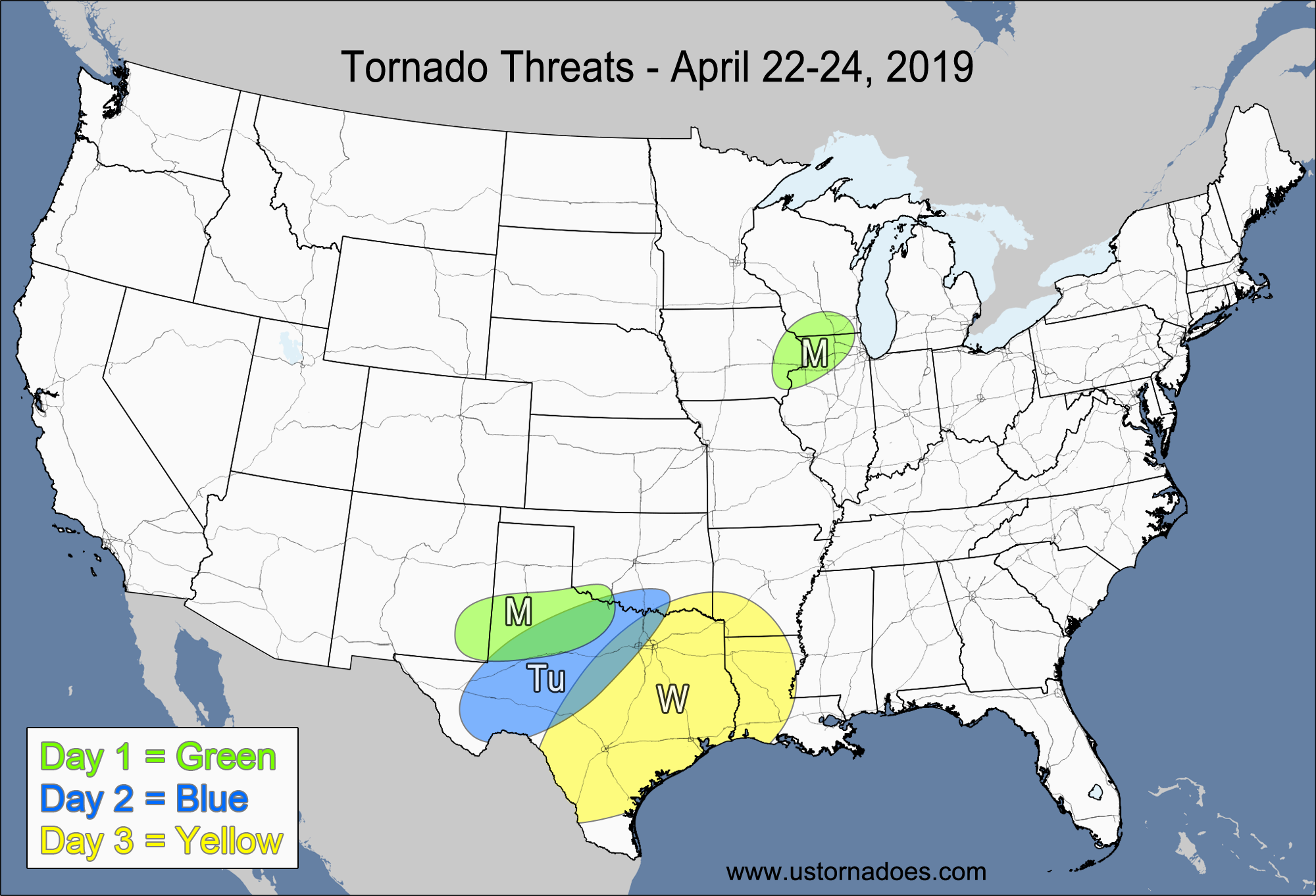
1-3 DAY
Thursday
Central Plains, southwestern Midwest — POTENTIAL: Medium — CONFIDENCE: Normal
Storms will form along and ahead of a cold front today into tonight, with moderate to high amounts of CAPE on the order of 1500-3000+ J/kg to support strong to severe storms. Helicity will be maximized along a warm front that will be lifting through MO and far southern IA, but storms that do form will have to form south of the warm front and stay surface-based to generate the tornado threat. A cap will be in place over the warm sector through most of the afternoon, slowly eroding and allowing for storm development by the late afternoon or early evening. Moderate low-level shear will aid in tornadic storm formation, but a lack of stronger winds aloft and weak dynamics will limit the tornado potential.
Friday
Southern Midwest, northern Tennessee Valley— POTENTIAL: Very Low — CONFIDENCE: High
Low to moderate instability in the vicinity of a weak cold front will allow for strong to severe storms to develop, but weak dynamics, high LCLs and a largely-unidirectional wind profile will limit the tornado potential.
Saturday
West-central Midwest — POTENTIAL: Low — CONFIDENCE: Normal
Low to moderate CAPE and moderate wind shear behind a warm front will allow for storms to gain rotation and possibly produce a tornado. A cap will be in place during most of the day, limiting the threat through most of the afternoon. Tornadic potential will also be kept low due to a lack of upper-level dynamics.
4-7 DAY
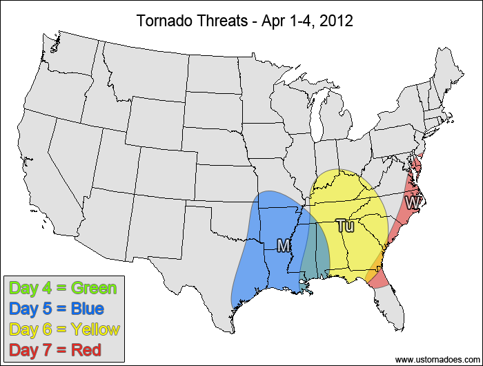
Sunday
No tornadic activity expected.
Monday
Southeastern Plains, western Southeast — POTENTIAL: High — CONFIDENCE: Normal
A potent upper-level low will try to cut off from the main flow on Monday as it moves through the southern Plains into the lower Mississippi Valley. This upper-level disturbance could create a secondary surface low along a cold front, creating an environment favorable for tornado development. In addition to the upper-level low, moderate to high CAPE and wind shear will allow for the potential for a tornado outbreak. The timing, position and intensity of the storm is not consistent enough on the models on a run-to-run basis to allow for high confidence, but the potential for at least several tornadoes is present.
Tuesday
Southeast, Tennessee Valley — POTENTIAL: Medium — CONFIDENCE: Normal
As the disturbance pushes eastward, there will still be a decent tornado threat ahead of the cold front, but widespread clouds and rain within the risk area will limit the instability and lower the overall potential. Model differences concerning the progression and evolution of this system start to become large by this point, but there is potential for isolated tornado activity.
Wednesday
Eastern Southeast, southeastern Mid-Atlantic — POTENTIAL: Low — CONFIDENCE: Low
There is a high amount of uncertainty in the progression of the system as it approaches the East Coast, with some models taking the system offshore by Wednesday as the GFS Operational provides a slower solution that would allow storms to form along the East Coast Wednesday afternoon. If the system is slower, there will be a low potential for tornadoes on Wednesday, otherwise the faster solutions would obviously provide no tornado threat.
Latest posts by Mark Ellinwood (see all)
- Spring 2023 seasonal tornado outlook - March 1, 2023
- Spring 2022 seasonal tornado outlook - March 1, 2022
- Spring 2021 seasonal tornado outlook - March 1, 2021