1-3 DAY
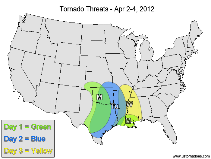
Monday
Southern Plains — POTENTIAL: Medium — CONFIDENCE: Normal
An upper-level disturbance will work into the southern Plains late today into tonight, with the height falls and associated cap erosion eventually creating an environment favorable for isolated tornadic storms. Timing and the strength of the wind shear will be the main concerns limiting the tornado threat as the CAPE peaks at moderate to high values in the afternoon before falling to low to moderate values overnight.
Southern Delta — POTENTIAL: Very Low — CONFIDENCE: Normal
Some leftover instability could trigger storms with tornadic potential south and east of a Mesoscale Convective System currently moving through the southern Delta.
Tuesday
Southern Plains, southern Delta— POTENTIAL: Low — CONFIDENCE: Normal
As the system progresses eastward, pre-frontal clouds and rain are expected to inhibit tornadic storm formation. In addition, a lack of upper-level wind support will inhibit storm organization, limiting the tornadic potential. However, enough instability and shear is present to allow for a low tornado threat.
Wednesday
ArkLaTex, western Southeast — POTENTIAL: Low — CONFIDENCE: Normal
A low potential continues to exist with the advancing line of storms going into Wednesday, but in the western parts of the risk area new convection is expected to form as the upper-level low starts slide eastward, increasing the forcing and shear in a moderately unstable environment. The models are starting to diverge fairly significantly with respect to the storm evolution at this range.
4-7 DAY
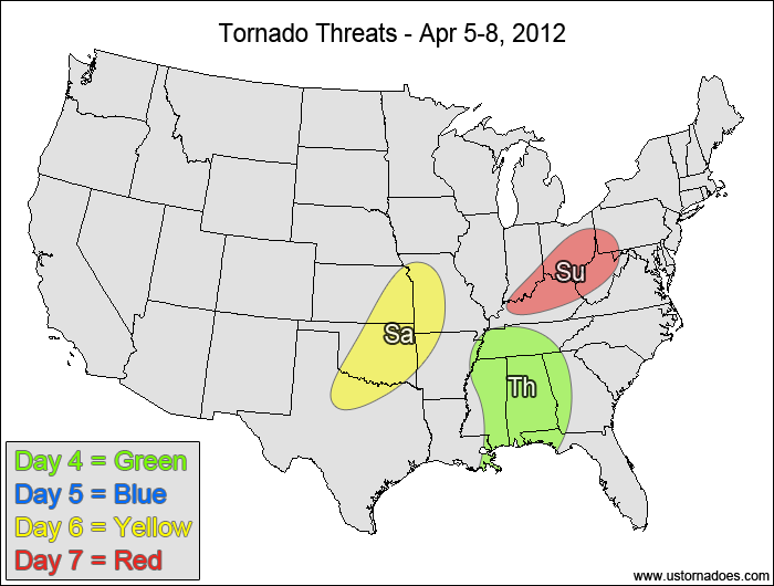
Thursday
Southeast— POTENTIAL: Low — CONFIDENCE: Low
Confidence is lowered due to the larger model discrepancies in storm evolution at this range. Enough instability and shear remain present with this system to elicit a low tornado risk for Thursday.
Friday
No tornadic activity expected.
Saturday
LOCATION — POTENTIAL: Low — CONFIDENCE: Low
Storms are forecast to form along a cold front stemming from a developing low as it moves from the northern Plains into the Midwest, however the instability and strongest shear/dynamics will be largely de-coupled, keeping the tornado threat low.
Sunday
LOCATION — POTENTIAL: Low — CONFIDENCE: Low
Continued lift along and ahead of a cold front will provide a low tornado risk as the system progresses into the eastern Great Lakes.
Latest posts by Mark Ellinwood (see all)
- Spring 2023 seasonal tornado outlook - March 1, 2023
- Spring 2022 seasonal tornado outlook - March 1, 2022
- Spring 2021 seasonal tornado outlook - March 1, 2021