1-3 DAY
UPDATE: Added southern Florida risk area for Saturday.
Thursday
Iowa, northern Missouri — POTENTIAL: Very Low — CONFIDENCE: High
Storms forming just ahead of a surface low will be in an environment with moderate shear and low CAPE, which with enhanced lift from an upper-level vorticity maximum will allow for the possibility of a tornado. High LCLs and limited low-level moisture will work against tornadic development. These storms are expected to become more linear during the overnight hours as the instability fades.
Central Oklahoma, north-central Texas — POTENTIAL: Very Low — CONFIDENCE: Normal
Storms forming along the cold front in Oklahoma and Texas will initially be high-based, but as the LCLs lower in the evening hours and the low-level jet strengthens there will be a brief opportunity for a tornado before the instability wanes.
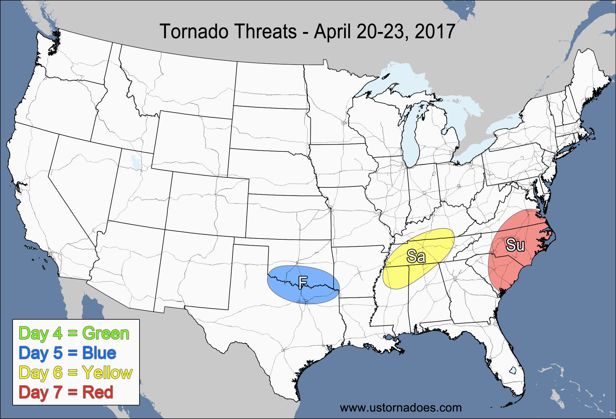
Friday
No tornadic activity expected.
Saturday
Southern Delmarva, southeast VA, eastern NC — POTENTIAL: Very Low — CONFIDENCE: Normal
Low to moderate CAPE ahead of a cold front will provide enough energy to trigger strong to severe storms, but mostly unidirectional flow and weak winds aloft will inhibit storm rotation. Some localized backing along the coastal areas from sea breezes could allow mature storms to gain enough rotation for a brief tornado.
Southern Florida — POTENTIAL: Very Low — CONFIDENCE: Normal
A disturbance moving across the eastern Gulf will bring moderate shear into the southern half of Florida, but prefrontal convection and extensive cloud cover could inhibit the overall instability.
4-7 DAY
Sunday
No tornadic activity expected.
Monday
No tornadic activity expected.
Tuesday
No tornadic activity expected.
Wednesday
Southern Midwest — POTENTIAL: Very Low — CONFIDENCE: Low
Storms forming south of a warm front will be in a low to moderate shear and low to moderate CAPE environment, but they will be working against a cap and weak forcing. The models differ greatly in the timing, placement and strength of the large-scale features at this range, keeping confidence very low.
Latest posts by Mark Ellinwood (see all)
- Spring 2023 seasonal tornado outlook - March 1, 2023
- Spring 2022 seasonal tornado outlook - March 1, 2022
- Spring 2021 seasonal tornado outlook - March 1, 2021