A strong upper-level disturbance will work into the Plains on Tuesday and will push into the eastern U.S. Wednesday, creating two potential days of tornadic activity. The higher risk will be on Tuesday as a secondary surface low develops over or near Missouri, which could cause more backing in the surface winds as well as enhance lift. This will set the stage for what will likely be a tornado outbreak, with the greatest tornado threat focused in MO, AR, KY, TN, MS, LA and eastern TX. There are some notable mitigating factors that could/should keep this system from going gangbusters. Some of these factors are very conditional and will have to be analyzed in a nowcast scenario in order to determine how significant this event will be. Some of the storm analogs suggest an historic event is possible, but right now it looks like that is not probable.
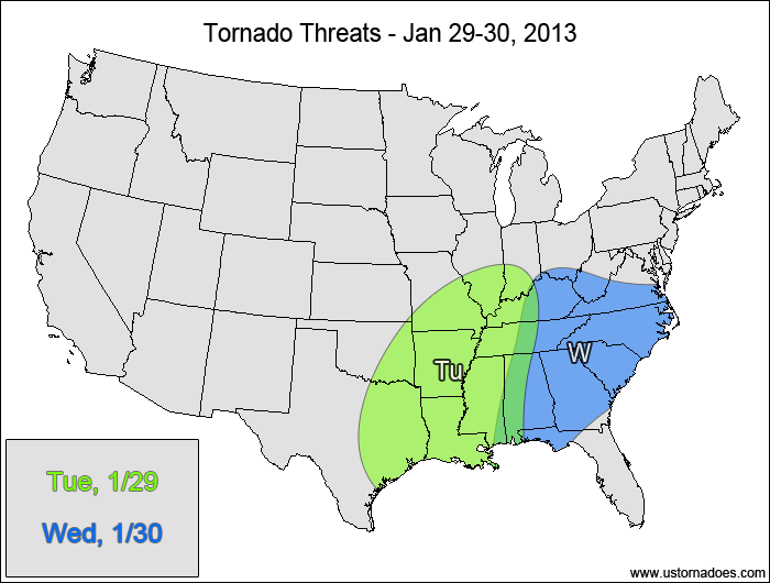
Tuesday
Mid-South — POTENTIAL: High — CONFIDENCE: High
A tornado outbreak is likely Tuesday into Tuesday night as the disturbance strengthens over the Mid-South. The main threat from this system will be damaging winds, but two opportunities exist for tornadic activity from the afternoon through the overnight hours. The cold front will generate a QLCS that is forecast to mature into a more linear threat overnight. However, with backed winds at the surface just ahead of the front, embedded supercells and tornadoes will be possible. Ahead of the QLCS, pre-frontal supercells could form and trigger more tornadoes. The QLCS and possible pre-frontal supercells are forecast to last through the overnight hours into Wednesday morning, making for very hazardous conditions. Some strong tornadoes are also possible. As far as mitigating factors, a somewhat-stable boundary layer is possible in the northern parts of the risk area, which would help keep mesocyclonic rotation from reaching the ground. There is also the chance that the QLCS will be more linear in nature, which would lower the embedded tornado potential. A lack of instability partly due to earlier convection (“crapvection”) ahead of the main line of storms could also hinder tornadic development, but with such a strong system, only marginal CAPE of 500-1000 J/kg will be needed to produce a tornado outbreak.
Wednesday
Southeast, Tennessee Valley, southern Mid-Atlantic — POTENTIAL: High — CONFIDENCE: Normal
The threat continues along the QLCS throughout Wednesday, with some pre-frontal supercells remaining possible, especially across the southern parts of the risk area. The tornado risk decreases as the storm approaches the Appalachians and the East Coast. In addition to the factors listed earlier that could hinder tornado development, height rises east of the Appalachians will work against any sort of pre-frontal supercell possibilities, keeping the main/only risk along the cold front once it reaches that area. Despite the inhibiting factors, at least a few tornadoes are expected on Wednesday, which fits our definition of a high risk.
Latest posts by Mark Ellinwood (see all)
- Spring 2023 seasonal tornado outlook - March 1, 2023
- Spring 2022 seasonal tornado outlook - March 1, 2022
- Spring 2021 seasonal tornado outlook - March 1, 2021
How’s that “tornado outbreak” working out for ‘ya?
Looks good. Six reports and counting now. So far all are within the forecast risk area (though given how large the risk area is, that doesn’t mean much).
http://www.spc.noaa.gov/climo/reports/130129_rpts.html
Jb
???
Mark Ellinwood was right, 57 tornados Jan 29 and Jan 30
http://en.wikipedia.org/wiki/List_of_United_States_tornadoes_from_January_to_February_2013