Spring is alive with the sights and sounds of tornadoes! There aren’t a lot of them, but the day-to-day numbers will start to add up as we head into the middle of the month.
1-3 Day
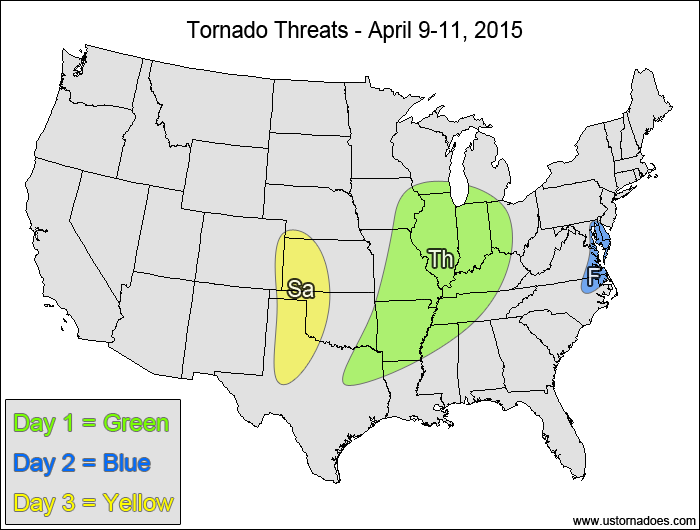
Thursday
Midwest, central Miss. Valley — TORNADO RANGE: 3-8 — CONFIDENCE: Normal
Expected Tornado Hotspot: West-central Illinois
Pros: Good speed shear, decent low-level directional shear, moderate instability, good upper-level forcing.
Cons: Fairly unidirectional flow aloft, storms lining out along the cold front, pre-frontal cloud cover and showers/storms stabilizing the atmosphere.
Friday
Southeastern Mid-Atlantic, northeastern North Carolina — TORNADO RANGE: 0-1 — CONFIDENCE: High
Expected Tornado Hotspot: None
Pros: Good speed shear, low to moderate instability, possible local enhancement of backing winds at the surface.
Cons: Poor directional shear, storms lining out along the cold front.
Saturday
Southern and central High Plains — TORNADO RANGE: 0-2 — CONFIDENCE: Normal
Expected Tornado Hotspot: None
Pros: Good directional shear, decent speed shear, low to moderate instability.
Cons: Neutral/rising heights, , uncertainty in storm coverage, possible capping and/or LCL issues.
4-7 Day
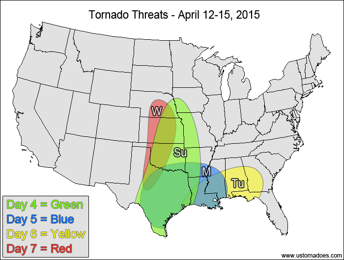
Sunday
Central and southern Plains, Miss. Valley — TORNADO RANGE: 2-6 — CONFIDENCE: Low
Expected Tornado Hotspot: None
Pros: Decent/good speed and directional shear, low to moderate instability, decent upper-level forcing.
Cons: Earlier clouds and showers/storms could limit instability, uncertainty in the storm modes, best dynamics don’t line up well with best instability.
Monday
Southeastern Plains, southern Miss. Valley — TORNADO RANGE: 1-4 — CONFIDENCE: Low
Expected Tornado Hotspot: Southeastern Plains
Pros: Decent/good directional shear, low to moderate instability, some upper-level forcing over Texas.
Cons: Cloud cover and earlier storms working over the atmosphere, somewhat weak speed shear, uncertainty in the storm modes.
Tuesday
Deep South — TORNADO RANGE: 0-2 — CONFIDENCE: Low
Expected Tornado Hotspot: None
Pros: Low to moderate instability, areas of decent low-level shear near a warm front.
Cons: Somewhat weak speed shear, weak directional shear in most of the warm sector, weak upper-level dynamics, cloud cover and earlier storms working over the atmosphere.
Wednesday
Central and southern Plains — TORNADO RANGE: 0-3 — CONFIDENCE: Low
Expected Tornado Hotspot: None
Pros: Decent/good upper-level dynamics, good directional shear, decent speed shear.
Cons: Questionable instability and storm coverage, best dynamics separated from best instability.
Latest posts by Mark Ellinwood (see all)
- Spring 2023 seasonal tornado outlook - March 1, 2023
- Spring 2022 seasonal tornado outlook - March 1, 2022
- Spring 2021 seasonal tornado outlook - March 1, 2021