Tornado highlights covering the week of April 26-May 2, and a brief look ahead.
Other than the first two days of last week — mostly Sunday, April 26 in Texas — the past seven was quite tranquil when compared to what can happen in late April and the beginning of May when it comes to severe weather.
As of publish, the last tornado warning was issued more than five days ago. There have been no watches in that time frame either.
Despite the quiet period, we are into the peak of the peak when it comes to tornadoes historically, and storminess is slowly returning to the central U.S. A general ramp up in activity should continue during the week ahead.
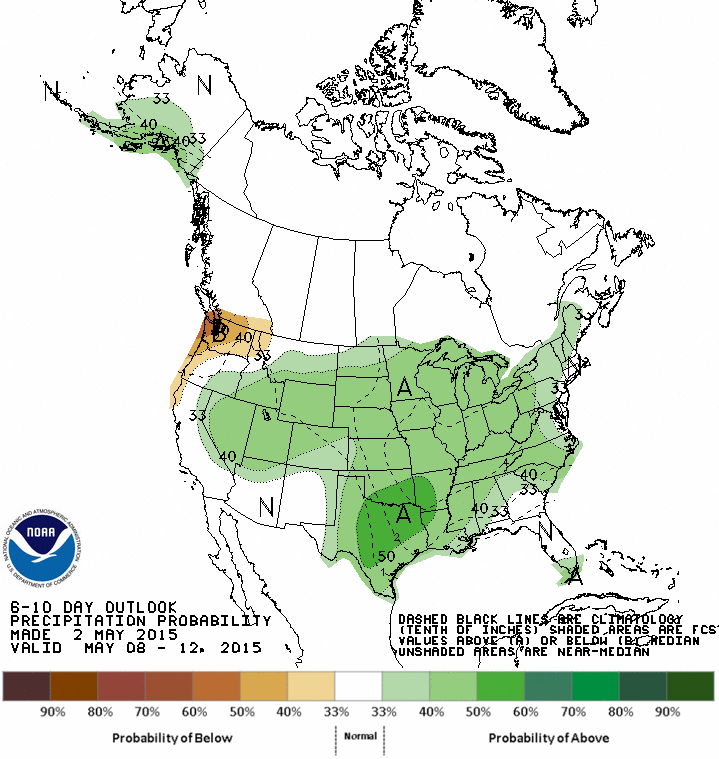
Last week’s summary map
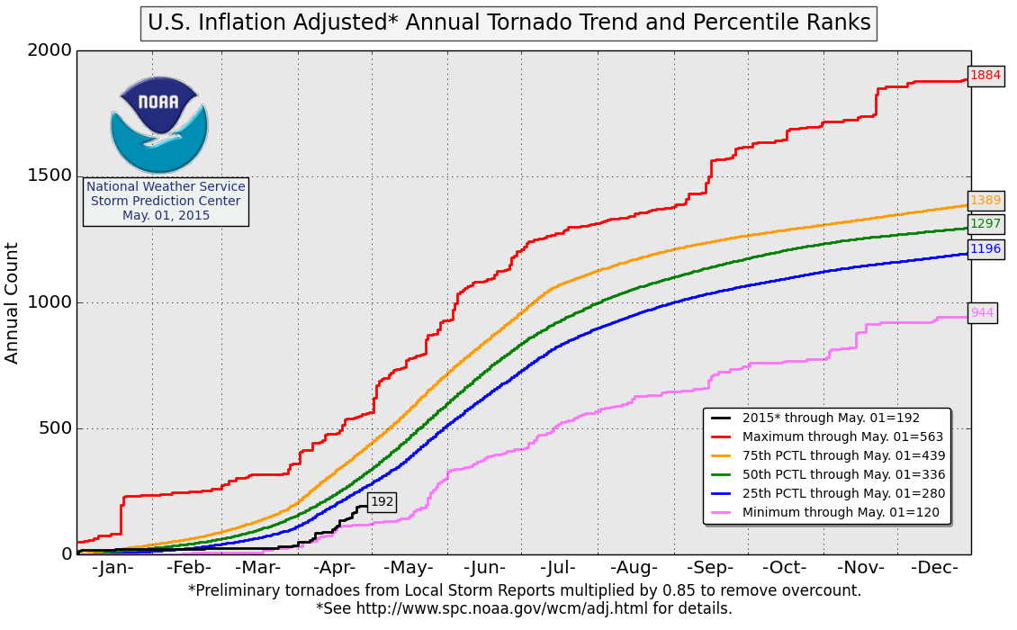
And a few stats
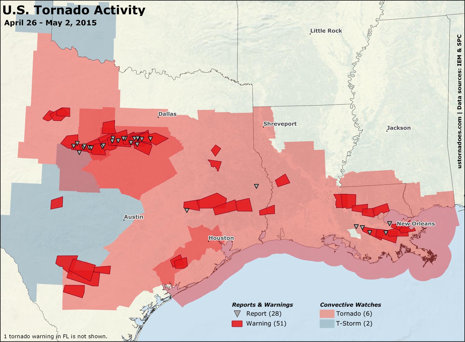
There were only eight convective watches issued by SPC during the week ending May 2. All came on the first two days. Same story on the tornado reports and 51 warnings. Since that southern system cleared, a few severe storms have occurred, mainly on the front range and in the Plains to Midwest region. Nothing of major note.
Related: Tornado Digest archives
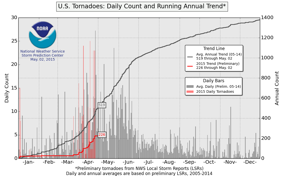
April’s tornado numbers, probably finishing between 165-185 or so, are right around normal for the month. Despite a slow start to the year, the active period that just finished keeps 2015 safely ahead of the low point (de-trended), at least for now.
So, let’s say a last goodbye to April… and hello to May.
April 26: Texas
As a powerful mid-level trough pushed out into the Southern Plains, a moderate risk (for hail) was issued by the Storm Prediction Center across a small portion of Texas. Within that area, a zone of strong tornado potential also presented itself.
10% hatch tornado in MOD risk (for hail) upgrade. Strong tor poss includes Dallas area. http://t.co/h3zgIBiXDh pic.twitter.com/Kf4DozV7Cd
— U.S. Tornadoes (@USTornadoes) April 26, 2015
At first, one supercell was dominant and marched east to the southeast of Abilene. Later in the evening, a supercell cluster formed south of the Dallas metro area.
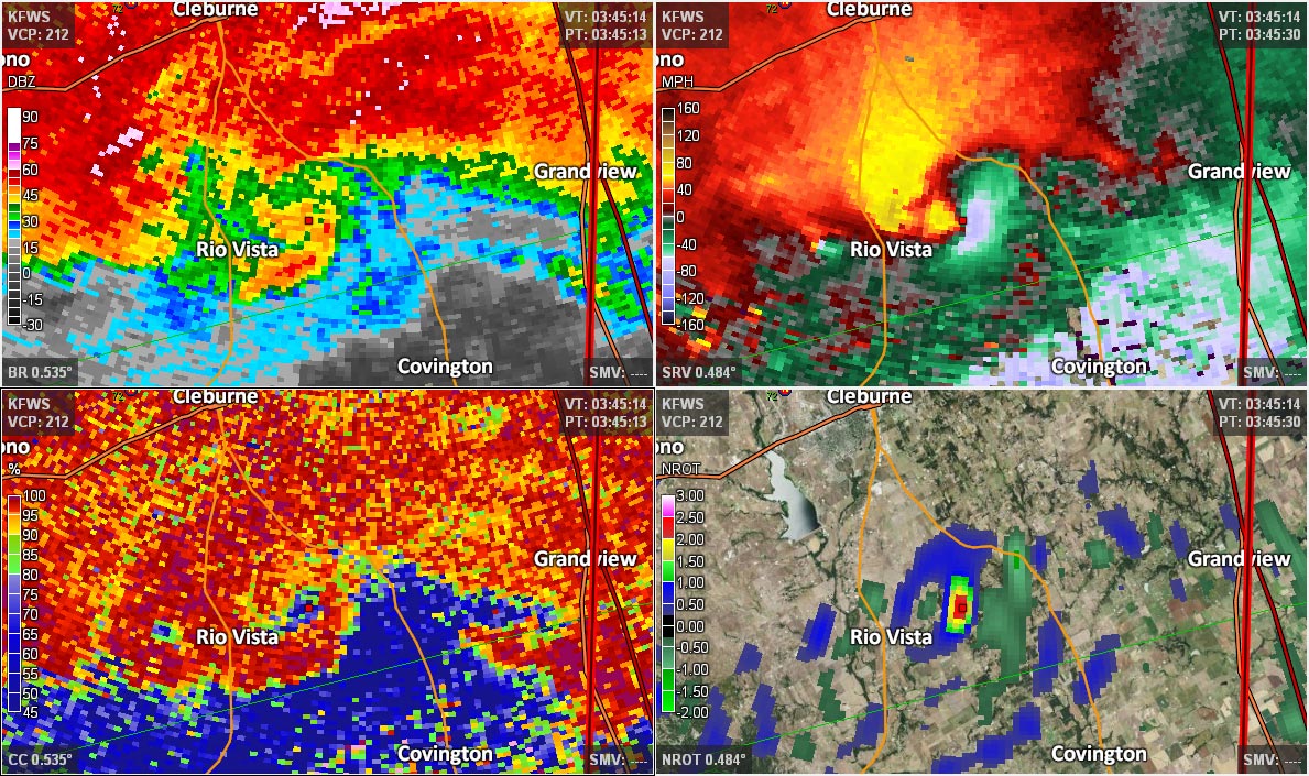
Near Stephenville, Texas…
Video: Ben Holcombe
Cone tornado on the ground 3 miles sw of Rio Vista #TxWx 5 minutes ago @NWSFortWorth @KOCOjonathan @LiveStormsMedia pic.twitter.com/c2YGsswWUe
— Lawrence M 🇺🇸 (@LawrenceWx91) April 27, 2015
This is incredible @CoDWXData @USTornadoes @StormCoker @JWSevereWeather @Basehunters @NWSFortWorth @tornadotrackers pic.twitter.com/BjmU3SJqrC
— Joey Krastel (@NimbusStorms) April 27, 2015
Over 20 tornado reports came in across central Texas, and at least 12 EF0s were confirmed within the NWS Fort Worth county area. There was yet ANOTHER debate about bad wedge reports.
One more tornado confirmed from last Sunday. Here's all of them in one map. http://t.co/SCwG2VFALj #dfwwx #txwx pic.twitter.com/iSjBVgMrU2
— NWS Fort Worth (@NWSFortWorth) May 2, 2015
April 27: Louisiana
Severe weather continued east into the northern Gulf Coast on Monday, with Louisiana facing most of the major weather impacts as well as a handful of tornado reports. Both Baton Rouge and New Orleans faced tornado threats. The video of the day was wind associated, but straight-line in nature, as parts of a train were blown off tracks in NOLA.
Tornado Warning including Baton Rouge LA, Denham Springs LA, Port Allen LA until 9:45 AM CDT pic.twitter.com/m2SYRPPhKG
— NWS Tornado (@NWStornado) April 27, 2015
Tornado recently reported in Naval Air Station Joint Reserve Base New Orleans obs http://t.co/74rGtzNF4R h/t @WxNick pic.twitter.com/6vM6KitH4Z
— U.S. Tornadoes (@USTornadoes) April 27, 2015
Next in line
The month has started quiet, but that should change ahead
Although this ongoing stretch we are in is the quietest for tornadoes during the peak season of April-June 2015 so far, it’s not really unheard of at this point in the season. Tornado days generally reach peak between mid-May and June.
A storm system moving east today has had trouble doing a whole lot more than create isolated severe weather, partly because the northern jet is largely displaced to the north of the best surface conditions. The southern jet is being a bit lazy out west at the moment.
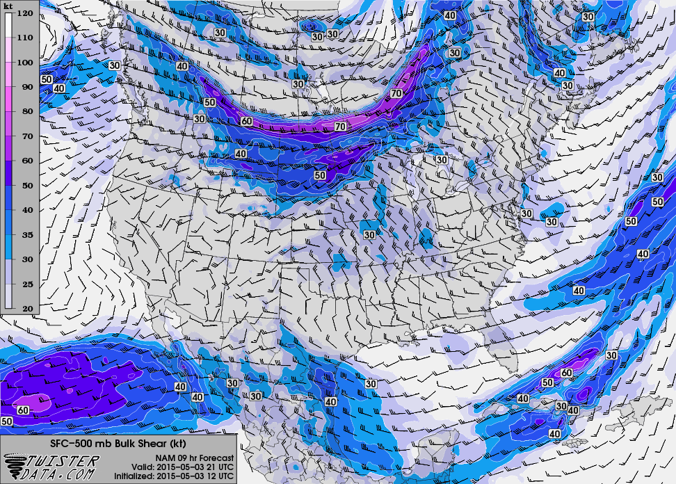
In the week ahead, more mid-level low pressure formation is expected over the western United States. Little waves are likely to spit out across the Rockies and into the central part of the country fairly regularly. At the least, it should be an active rainfall and general t-storm period. Significant rainfall is expected across much of Plains and surrounds.
Since it’s May, probably at least a few tornadoes as well despite not the best mid-level flow for much of the period. The first “heightened threat” day for tornadoes may come as soon as Wednesday per recent models.
There are some indications that after a several-day dance across the western U.S. and Rockies, the full trough will eject out into the Plains around late week or next weekend. If it pushes out right, it could certainly have some higher-end potential.
It may also set the stage for several days of severe weather risk by mid-to-late week as it meanders to the east.
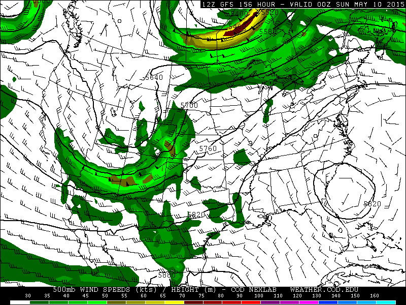
Even beyond this coming week, ensemble modeling tends to suggest a pattern with more tendency for “trough west and ridge east” may continue. Generally favorable for severe weather chances this time of year.
Latest posts by Ian Livingston (see all)
- Top tornado videos of 2023 - January 1, 2024
- March 31, 2023 tornado outbreak videos - March 31, 2023
- Top tornado videos of 2022 - December 31, 2022