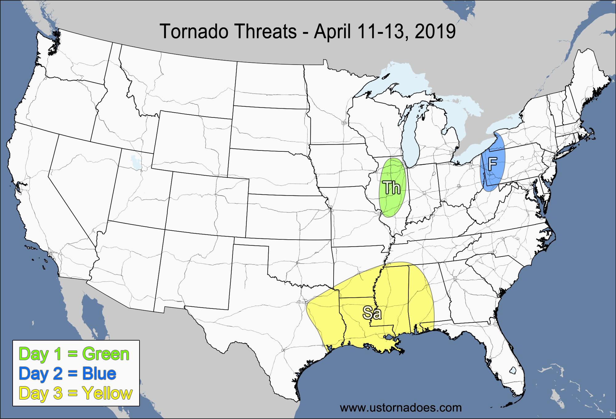
1-3 DAY
Monday
Northern Mid-Atlantic — POTENTIAL: Very Low — CONFIDENCE: High
Storms forming along and ahead of a cold front will be in an environment with low CAPE and moderate to high speed shear, allowing storms to potentially become organized. However, the winds will be largely unidirectional and LCLs will be fairly high, keeping the tornado potential to a minimum.
Southern Texas — POTENTIAL: Very Low — CONFIDENCE: Normal
Mature storms in a low CAPE/low to moderate shear environment could briefly become tornadic.
Tuesday
Southeast — POTENTIAL: Very Low — CONFIDENCE: Normal
Low CAPE and low shear ahead of a cold front could be enough to put down a brief tornado
Wednesday
Missouri, central Illinois — POTENTIAL: Low — CONFIDENCE: Normal
Low to moderate CAPE and low to moderate shear ahead of a cold front could allow stronger storms to rotate, but the weak low-level speed shear and moderate to high LCLs will limit tornado formation.
4-7 DAY
Thursday
Missouri, Illinois— POTENTIAL: Very Low — CONFIDENCE: Normal
Storms forming south of a frontal boundary will have enough low-level rotation within a low CAPE/low to moderate shear environment to rotate storms as a shortwave trough moves into the region. High LCLs and the risk for more unidirectional low-level winds will keep the potential limited.
Friday
Southeastern Texas — POTENTIAL: Very Low — CONFIDENCE: Low
Storms that form ahead of a cold front in an environment with moderate to high CAPE and low shear could rotate and a very mature storm could potentially become tornadic.
Saturday
Southern Mid-Atlantic, Southeast — POTENTIAL: Low — CONFIDENCE: Low
The primary low that created the Thursday threat will push into the Mid-Atlantic on Saturday, allowing for low to moderate shear in a low CAPE environment that would be capable of producing a tornado in the southern Mid-Atlantic. A secondary low is expected to form along the cold front in the Southeast as a vorticity maximum digs into the base of the longwave trough, but the development and progression of this low is very inconsistent on the models, which will keep the confidence low. The latest model runs seem to favor a neutral or negative tilt to the trough as the secondary low develops, which would limit or eliminate the tornado threat in the Southeast. However, a faster pattern progression and/or a more positively-tilted trough could bring about a higher tornado threat.
Sunday
No tornadic activity expected.
Latest posts by Mark Ellinwood (see all)
- Spring 2023 seasonal tornado outlook - March 1, 2023
- Spring 2022 seasonal tornado outlook - March 1, 2022
- Spring 2021 seasonal tornado outlook - March 1, 2021
oh no tornado might hit my area punxsy but very low so i am not that worried
still worried but i never seen a tornado before