1-3 DAY
Thursday
No tornadic activity expected.
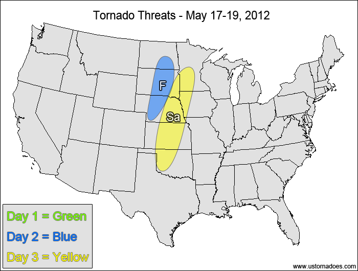
Friday
Northern Plains — POTENTIAL: Very Low— CONFIDENCE: Normal
Low shear and low to moderate CAPE will be in place over the northern Plains as a developing disturbance moves into the region. Mid-level winds will generally be weak in the areas with the greatest instability, and a lack of low-level moisture and high LCLs will limit the tornado potential.
Saturday
Plains, western Midwest — POTENTIAL: Low— CONFIDENCE: Normal
A similar setup to Friday will carry into Saturday as the disturbance and its cold front pushes eastward. Storm coverage is expected to be greater, but a fairly stout cap along with Friday’s limitations will keep the tornado potential on the low side.
4-7 DAY
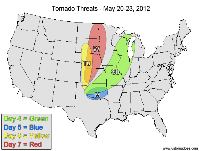
Sunday
Central Plains, western Midwest — POTENTIAL: Low— CONFIDENCE: Normal
Storms will continue to form along and ahead of a cold front in a low to moderate CAPE and low shear environment. The storms in the Plains will be more likely to have some low-level directional shear as the winds become more unidirectional in the western Midwest. Wind speed shear will be very weak throughout most/all of the risk area, but storms that can interact with mesoscale boundaries may be able to produce a tornado.
Monday
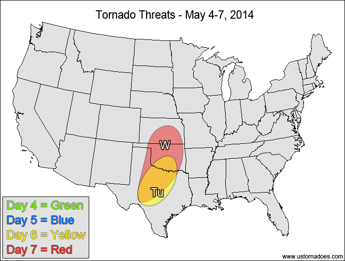
Oklahoma, north-central Texas — POTENTIAL: Very Low— CONFIDENCE: Normal
Storms forming in a very low shear and low to moderate CAPE environment may be able to produce a tornado thanks to the directional shear that will be in place.
Tuesday
Plains — POTENTIAL: Low— CONFIDENCE: Normal
A better storm environment will begin to set up over the Plains on Tuesday, but there will be a disconnect between the better moisture in the southern areas and better shear in the northern areas, which will keep the potential limited.
Wednesday
Northern and central Plains, northwestern Midwest — POTENTIAL: High — CONFIDENCE: Low
Model agreement regarding the evolution and placement of the disturbance has become poor at this range, but there is a general agreement that an upper-level trough will be working into the Plains on Wednesday, bringing moderate speed shear and low to moderate CAPE together. These elements will be accompanied by favorable directional shear and moistening low-levels as moist air from the Gulf gets advected northward by a strong low-level jet. The biggest issue with respect to the confidence is the size and placement of the risk area, but the potential is high regardless of where the risk area ends up getting refined to in the coming days.
Latest posts by Mark Ellinwood (see all)
- Spring 2023 seasonal tornado outlook - March 1, 2023
- Spring 2022 seasonal tornado outlook - March 1, 2022
- Spring 2021 seasonal tornado outlook - March 1, 2021