We’ve got a bunch of smaller events expected through the work week, with perhaps some more notable tornado activity lined up for the Plains and western Midwest this weekend. I would think there’s more upside potential than downside with this weekend’s setup, but we will revisit those days in the next forecasts with a bit better clarity.
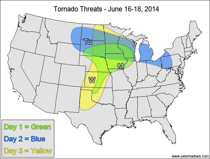
1-3 Day
Monday
Northeastern Oklahoma, south-central Kansas — TORNADO RANGE: 0-1 — CONFIDENCE: High
Expected Tornado Hotspot: None
Pros: Good upper-level dynamics, area of decent directional and speed shear
Cons: Low instability, questionable lapse rates, limited area of decent directional shear
Southern Mississippi Valley — TORNADO RANGE: 1-3 — CONFIDENCE: Normal
Expected Tornado Hotspot: None
Pros: Moderate to high instability, some low-level directional shear, good speed shear
Cons: Unidirectional flow aloft, main dynamics displaced from greatest instability, storm mode of mostly lines and bow echoes
Tuesday
Eastern North Dakota, northwestern Minnesota — TORNADO RANGE: 0-2 — CONFIDENCE: High
Expected Tornado Hotspot: None
Pros: Decent/good upper-level dynamics, some low-level directional shear, decent speed shear
Cons: Questionable instability and mid-level lapse rates, limited moisture
Tennessee Valley — TORNADO RANGE: 0-2 — CONFIDENCE: High
Expected Tornado Hotspot: None
Pros: Low to moderate instability, decent/good speed shear, decent/good upper-level dynamics
Cons: Weak directional shear, weak mid-level lapse rates, backing in the upper-levels
Wednesday
Central Plains, northwestern Midwest — TORNADO RANGE: 2-6 — CONFIDENCE: Normal
Expected Tornado Hotspot: None
Pros: Moderate to high instability, good/strong directional shear, decent/good speed shear
Cons: High LCLs in the central Plains
Mid-Atlantic — TORNADO RANGE: 0-3 — CONFIDENCE: High
Expected Tornado Hotspot: Southern Pennsylvania
Pros: Moderate instability, good low-level directional shear, decent speed shear, decent upper-level forcing in the northern areas
Cons: High clouds, potential for weak mid-level lapse rates, unidirectional mid to upper-level flow
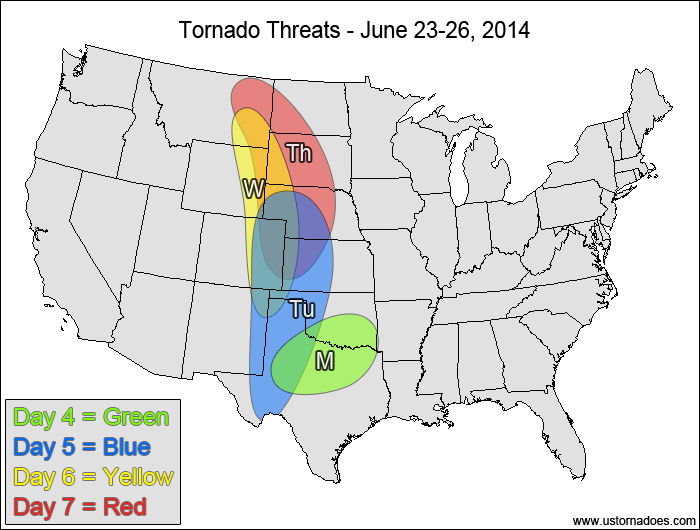
4-7 Day
Thursday
Colorado — TORNADO RANGE: 0-2 — CONFIDENCE: Normal
Expected Tornado Hotspot: None
Pros: Upslope flow, low to moderate instability
Cons: Possible mid-level capping, weak/okay speed shear
Southeastern Plains, mid-Mississippi Valley — TORNADO RANGE: 3-8 — CONFIDENCE: Normal
Expected Tornado Hotspot: None
Pros: Moderate to high instability, decent/good speed and directional shear, some upper-level forcing in the northern areas
Cons: Cloud cover in warm sector, none of the parameters are particularly strong
Friday
Northern High Plains — TORNADO RANGE: 0-3 — CONFIDENCE: Normal
Expected Tornado Hotspot: None
Pros: Good/strong directional shear, low to moderate instability
Cons: Upper-level forcing lags behind, questionable moisture, poor low to mid-level speed shear, capping concerns
Saturday
Plains — TORNADO RANGE: 4-12 — CONFIDENCE: Normal
Expected Tornado Hotspot: Central Plains
Pros: Strong directional shear, decent/good speed shear, good upper-level forcing in the northern areas, good mid to upper-level lapse rates
Cons: Mid to upper-level speed shear isn’t that great, capping concerns leading to questionable storm coverage in the southernmost areas
Sunday
East-central Plains, southwestern Midwest — TORNADO RANGE: 3-9 — CONFIDENCE: Normal
Expected Tornado Hotspot: None
Pros: Moderate to high instability, decent/good directional and speed shear
Cons: Cloud cover ahead of storms, morning convection could mess up the environment, mid-level lapse rates could be questionable in the northern areas, upper-level dynamics weaken
Latest posts by Mark Ellinwood (see all)
- Spring 2023 seasonal tornado outlook - March 1, 2023
- Spring 2022 seasonal tornado outlook - March 1, 2022
- Spring 2021 seasonal tornado outlook - March 1, 2021