Wednesday ended up being the biggest tornado day of the year so far. Over 50 preliminary tornado reports (actual tornado count will likely be lower), with surveys ongoing as of this post. The Plains will not catch a break until early next week, with another “big” tornado outbreak on a similar scale to yesterday looming in the near term. Parts of the Midwest are also expected to get in on the tornado action over the next several days.
1-3 Day
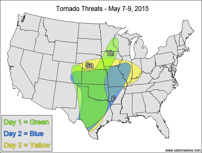
Thursday
Central and southern Plains, northwestern Midwest — TORNADO RANGE: 2-7 — CONFIDENCE: Normal
Expected Tornado Hotspot: Northern Texas, southern Oklahoma
Pros: Good/excellent directional shear, decent/good speed shear, moderate instability.
Cons: Some spots have weak mid-level speed shear, upper-level forcing is fairly weak, potential issues with backing winds in the upper levels in the Midwest, early convection in the Texas Panhandle could muck things up in area with best potential atmosphere.
Friday
Central and southern Plains, southwestern Midwest — TORNADO RANGE: 10-25 — CONFIDENCE: Normal
Expected Tornado Hotspot: Southern Kansas, western Oklahoma, north-central Texas
Pros: Good/excellent directional shear in the Plains, good speed shear in most spots, moderate to high instability in the Plains, low to moderate instability in the southwestern Midwest
Cons: Fairly weak directional shear in the southwestern Midwest, weak upper-level forcing.
Saturday
Central and southern Plains, southern Midwest — TORNADO RANGE: 20-60 — CONFIDENCE: Normal
Expected Tornado Hotspot: Southern Kansas, western Oklahoma, north-central Texas
Pros: Good/excellent shear in the Plains, moderate instability, good upper-level forcing, well-pronounced surface low.
Cons: Potential issues with backing winds in the mid-to-upper levels in the central Plains as the upper-level trough goes negative tilt, weak speed shear in the Midwest.
4-7 Day
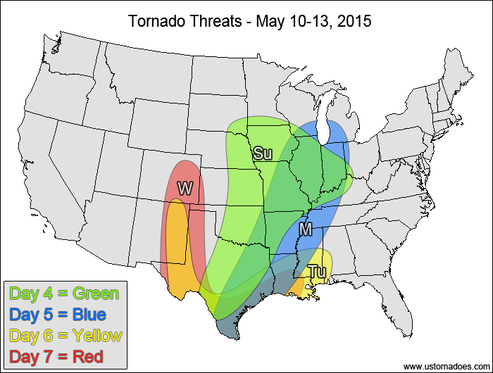
Sunday
East-central and southern Plains, Midwest — TORNADO RANGE: 8-24 — CONFIDENCE: Normal
Expected Tornado Hotspot: Western Midwest
Pros: Decent/good shear, low to moderate instability, decent/good upper-level forcing.
Cons: Cold front could cause storms to line-out fairly quickly, especially from northern Texas to Missouri, weak speed shear in the Ohio Valley.
Monday
Southeastern Plains, central and southern Miss. Valley, Midwest — TORNADO RANGE: 3-7 — CONFIDENCE: Low
Expected Tornado Hotspot: LOCATION
Pros: Good directional shear in the southeastern Plains, moderate instability, decent upper-level forcing in the Midwest.
Cons: Mostly linear+clustered storm mode, poor directional shear for most of the Midwest and Miss. Valley, weak speed shear in the southeastern Plains.
Tuesday
Southern High Plains, western Gulf Coast — TORNADO RANGE: 2-5 — CONFIDENCE: Low
Expected Tornado Hotspot: None
Pros: Good/excellent directional shear.
Cons: Low instability in most spots, weak speed shear for most of the risk area, little to no upper-level dynamics.
Wednesday
Central and southern High Plains, western Gulf Coast — TORNADO RANGE: 3-8 — CONFIDENCE: Low
Expected Tornado Hotspot: None
Pros: Good/excellent directional shear, low to moderate instability in most spots.
Cons: Lackluster speed shear, morning and afternoon clouds and rain could limit the tornado potential, poor upper-level dynamics in most areas, though some could arrive in time for the High Plains.
Latest posts by Mark Ellinwood (see all)
- Spring 2023 seasonal tornado outlook - March 1, 2023
- Spring 2022 seasonal tornado outlook - March 1, 2022
- Spring 2021 seasonal tornado outlook - March 1, 2021