A day like the one around Dodge City, KS on May 24, 2016 is easy to call the pinnacle of storm chasing. 44 tornadoes touched down in a regional outbreak centered on western Kansas. The storm we chased in the immediate surrounds of Dodge City produced a dozen on its own.
There are extraordinary chase days most years, then there are those that you know you won’t be seeing again for a really long time, if ever. Dodge City was the equivalent of the big one.
The sights, the sounds, the fearsome nature of earth’s most intense winds. We chase for the spectacle. Sometimes what we see is hard to understand or even fathom. Dodge City was one of those days.
First things first
May 2016 featured my sixth chasecation, all in consecutive years. My love of thunderstorms and tornadoes goes much further back, but a geography issue (I’ve lived on the East Coast for about 20 years now) tends to mean I am mainly an armchair chaser, or one who watches the action from home.
Although I’ve been at the real deal a while now, and I’ve seen quite a bit, I don’t consider myself among the “elite,” or even the well-known. Weather folks love a good pun, so I’ll give you a bad one: there are advantages to staying off the radar.
Elite or not, I am quite practiced. My opportunities are limited by vacation time, but there are not a lot of chasers who chase more than 10 days a year. That’s about my regular.
When it comes to picking chasecation dates, we go when tornadoes are most likely historically. It’s a simple but necessary calculation when you need to ask for time off weeks or months in advance. Fortunately, it tends to play out fairly well year to year. The time we go also generally overlaps with increasingly great chasing terrain, largely in areas that are mostly only sparsely populated.
I do not consider myself an adrenaline junky. Seeing these storms is almost an otherworldly experience to me. Even for people who are not heavily religious, it is hard not to believe in something greater when standing next to these beasts of the Plains.
That’s why we keep coming back, even after we’ve seen it all.
What happens in Dodge…
The Super 8 in Dodge City, Kansas is where one of the best days of my life began. I know, not the likeliest first line in a tale of great adventure. For me, though, the earthen and almost intentionally mundane style of the two-story building will always hold a special place in my heart.
Why this bread box in the Plains? For starters, it sits in the middle of some of the flattest and most fertile parts of tornado country. May is the time to chase. Where else would we be?
While I have chased a lot of days, it was the first year I did so with Quincy Vagell. He’s a contributor to ustornadoes.com, and a tornado fiend as big as they come. While we met before this multi-state wind hunt, it’s always a bit of a guess as to how spending two weeks with anyone will go.
This story being published attests to the fact that we did indeed make it. I know I came away with new memories that will last a lifetime. Quincy heavily facilitated the trip and its success. He also made it enjoyable.
Storm photo! May 2016. Featuring @stormchaserQ @islivingston two dudes with opinions. I recommend following them, they are in the green car pic.twitter.com/CfeDVWRhz8
— Greg Johnson (@TornadoGreg) October 30, 2016
As most mornings, this one started with a cup or two of freshly-made and barely-coffee motel coffee. On a lucky day, and May 24 was by chance one of those days, there’s also a bowl of frosted flakes to go along with.
Morning, critical as it is to a functioning society, is perhaps the time of day I dislike most. I like to sleep in. I like to rise slowly. I like to think, and get lost in my own world.
This in mind, I’m at my most morning person during chasecation. And there’s a reason for that. Anticipation. There are other reasons, like the fun of the forecast, and of course the unknown of the day, plus the interesting sights like the 8 wonders of Kansas (the Ball of Twine is a personal fav). The big one is anticipation.
In something of a ritual that begins in earnest during March, the first thing my weary eyes gazed upon was the Storm Prediction Center (SPC) update. When I’m out chasing, this ritual becomes an addiction. Like a user of any mind-altering substance, I seek an SPC fix at specific intervals every few hours. Every. Day. Sometimes I stay up late into the night to get that one last taste before bed.
That morning I blinked slowly, letting my sleepy eyes square in on the prize.
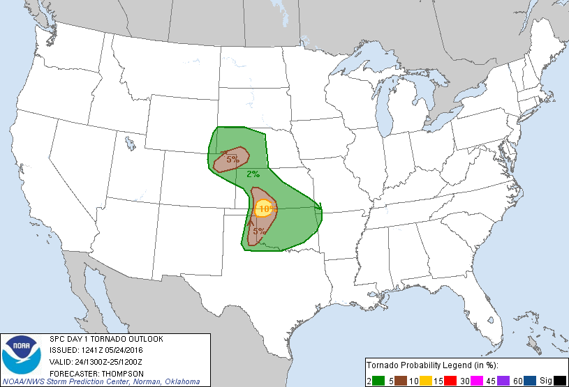
Any tornado probability within reach is a good thing for a storm chaser. Waking up to a 10 percent tornado risk — the color, a bright yellow beacon calling to me from my iPhone — is a big deal. It gets the blood pumping. It makes you forget it’s morning and you’re tired.
Anticipation.
I like to say I’ve seen pretty much everything. But on the morning of May 24, while eating my frosted flakes and sipping my mediocre coffee, I still only had slight inkling of what was to come later that day. The day held great promise but it did not necessarily have any peculiar feel outside of that.
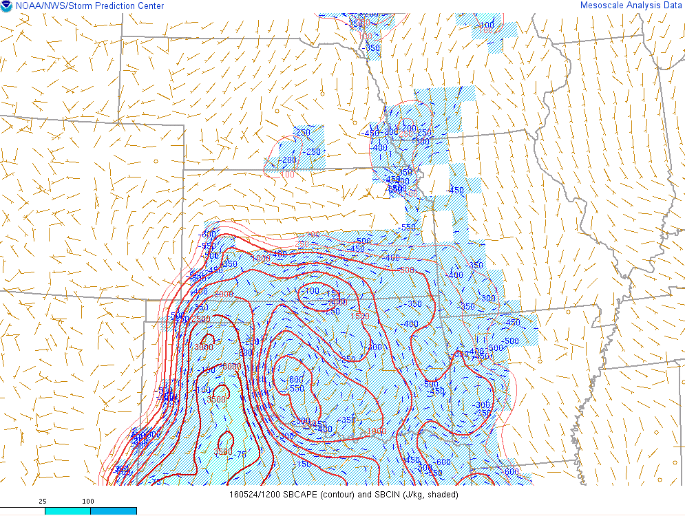
It’s important to understand that 10 percent tornado risks from the SPC usually mean tornadoes will happen in the area outlined. Many people see 10 percent and think, “oh, that’s not too high.” 10 percent is your odds of seeing a tornado within 25 miles of any point within the outlook contour. May 24 featured a 10 percent hugging the border of Oklahoma and Kansas. It was a small target and a loud signal that a tornado was very likely in or nearby that area. The chasers flocked.
The heart of it all
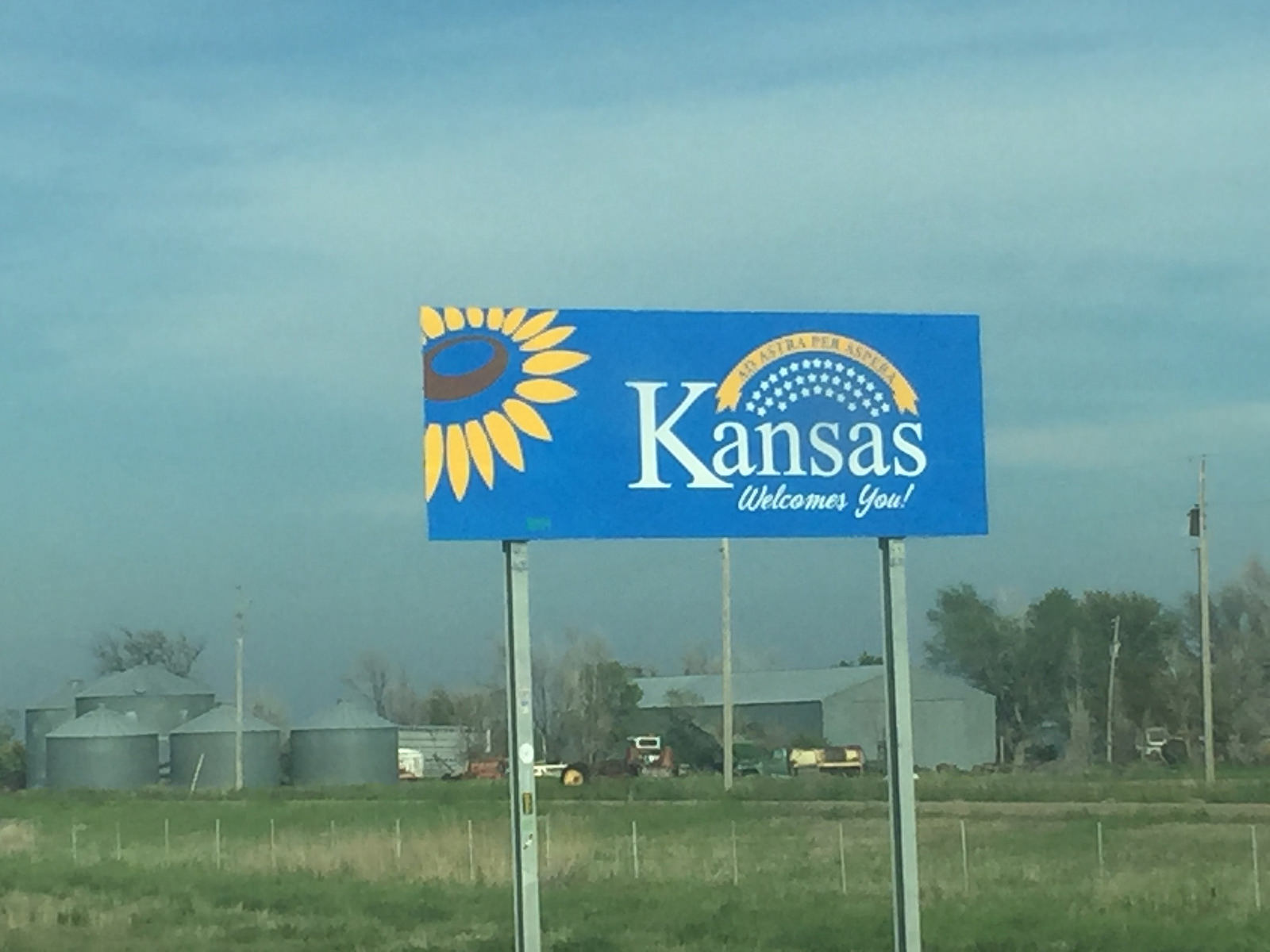
Dodge City sits about 50 miles north of the Oklahoma/Kansas border.
If you wake up close enough to the storm “bullseye” for the day that you are not scrambling to make a 6-hour drive, you consider yourself fortunate. We do tend to try to place ourselves close to the suspected target of the day, if possible the night before. Sometimes it’s more a matter of getting to a point that’s not as far as where you ended the chase the day prior. Like a game of chess, you usually have to at least think a move ahead, if not several.
But back to Dodge — it lies roughly where the High Plains make contact with the Central Great Plains. It’s a starkly featureless region, some of the flattest land you will find in the entire stretch of this magical part of the country. The more time you spend roaming the nation’s breadbasket, the more you find that tried and true definitions are hard to come by. It is a living and changing land, despite hardships faced in the past and today.
Dodge City is perhaps most well known for being a Wild West town that was home to folks like outlaw lawman Wyatt Earp, and also later for its central location in the Dust Bowl of the Dirty Thirties.
As you might guess given the Dust Bowl reference, it’s a relatively arid slab of land. The area only averages near or a little past 20 inches of rain per year. But, there’s a tight gradient of lower to higher precipitation across the Plains, and the area in and near Dodge City is considerably less arid than places a small distance west.
There’s a reason that majestically rotating supercell thunderstorms like to roam this region. That precipitation gradient is a big part of it.
In many ways, the city has the best of both worlds. You’ve got the beginnings of the amazing terrain of the High Plains, a largely treeless land where views can go for a 100 miles or more. It also lies roughly on the western edge of the more reliable part of “Tornado Alley,” particularly when it comes to the most powerful tornadoes as well as the most widespread tornado events.
In my chasing career, this part of Kansas has put on many a show. Dodge City NWS is the office that issued the life-saving warnings for the monster F5 Greensburg tornado. Many other well-known outbreaks have left their scars on the region.
If you wanted to see tornadoes and didn’t want to travel, I’d recommend Dodge. I’d be lying if I said I haven’t already planned out a life of retirement in which I spend at least three months every year in my Dodge City residence.
Back to reality
By lunch on May 24, Quincy and I were still chillin’ in Dodge.
A short distance down Wyatt Earp Boulevard — the same street we woke up on and one of Dodge City’s main strips — we sat in our car at a favorite of the chaser. Sonic. This was only after turning down other chase staples like Dairy Queen and Pizza Hut. Thing is, the Dodge City Sonic sits next to a massive set of grain elevators. While happily munching on fried chicken bites and eyeing the latest weather indicators, it just feels more authentic with these giants of the Plains blocking out the view.
To fully describe the scene, I need to point out Quincy was eating his health bar and drinking a water. In the case of Quincy and me, our style difference plays out strongest when it comes to food. I actually feel more or less at home with the terrible diet of storm chasing.
I was a kid of the 90s, when our economy was chugging along too fast to enjoy everything that was whizzing by. When the money is fast, so is the food. It was a great time for cheap and processed meals. As I wander into my mid-30s, this is finally starting to catch up with me enough to change habits. I still love me some fried anything while sitting in a car atop the flattest land on earth.
Quincy might be best described as a person who wants to live to be 120. He eats healthy and drinks a lot of water. I think I even saw some vegetables. Funny enough, I wondered if maybe it would come between us. He’s fortunately a good sport and didn’t seem to mind watching me fill my gut with what had to be 40,000 French fries and 850 cheeseburgers over the course of the two weeks. I wasn’t keeping count, I promise.
As we sat next to tons of crushed wheat and I gnawed on fried meat, Quincy was knee-deep in the latest conditions and monitoring key observations from ground-based radar and space-based satellite. By this point, both of us were pretty sure this had a good chance to be a top-notch day.
Even given vast increases in forecasting skill over the last several decades, individual storm days are still a peculiar animal.
There are many cases where quality setups don’t become apparent until the morning of. Even then, the odds are usually stacked against tornadoes. Bigger days can and often do bust. There’s a set of ingredients that is needed, and even with those ingredients present, another complex dance needs to be completed before a tornado happens. Like anything else, if you add too much of the ingredients, you don’t necessarily get a better product.
Let’s wander again here quickly — “a better product” … talking about tornadoes … how could I say that? This is a sentiment you hear as a storm chaser with some frequency. “Hoping” for events that can kill people is a tough one to grapple with. I admit it. I am still torn at times over this issue.
One thing you have to keep in mind in tales of chasing is that we’re out there to see the raw power of nature. To verify a forecast. To prove we can do it. It takes a special kind of strange to wish for harm upon others. Although I cannot say for sure there are no people like that out there chasing today, I don’t believe there are many. I have not met or interacted with any people that struck me in such a way. Folks like that have problems that are far bigger than chasing.
Your average chaser never sees a town destroyed. Lord knows we don’t want to. Ugh.
Severe weather is a part of life on the Plains. As previously mentioned, the region is rather arid despite acting as one of the main food producers in the world. Much of the annual precipitation comes from episodes of severe thunderstorms. Supercells — the mean rotating storms we are after — are often damaging, even without tornadoes. Massive hail can cause local losses. There are real things to be concerned about, but they are beyond our control as chasers.
Despite the necessity to go there, I still regret needing the diversion. I understand storm chasing is hard to explain. It is weird. It is unique. That’s part of why we like it.
May 24 wasn’t the biggest setup you’ll ever see. It was however fairly apparent in the days prior and it generally got more favorable as it closed. Those kinds of storm days are not the norm by any means. They don’t always work out either. As noted above, it is a fine balance. But this one had promise. And the promise was close by.
The chase begins
After lunch, it was time to go. But where?
Storm chasing is all about placement. I already alluded to that fact in the decisions that need to be made as far as a day or two in advance. But that game of placement continues well into the short term. Near and after noon, on a day that would spawn almost four dozen tornadoes in a region we found ourselves more or less centered on, it still wasn’t 100 percent apparent where to go. However, there were indicators.
Based on the latest data, we drifted about 25 minutes to the south of Dodge City. Our new home base was the small town of Minneola, Kansas.
Describing Minneola as a small town doesn’t really do it justice. It’s close to a micro town given its 2010 census population of 745 people. But it also acts as a hub for farming communities in the region. Despite its small size, Minneola is tenacious. Home to the Wildcats, in many ways it’s your classic American community.
A small park housing a beautiful baseball diamond to the south of town was our destination for much of the afternoon of May 24.
Storm trying to get going near Minneola, KS with @islivingston @stormchaserQ @ahberrington pic.twitter.com/hDrJl8OHNs
— Paxton Biggs (@PaxBiggs) May 24, 2016
Storm chasing is also all about waiting. Sometimes it really seems that all we do is wait. Wait for the next set of observations. Wait for the next set of short-term models. Wait for the clouds to break the cap of warm air aloft that often inhibits early thunderstorm formation.
And that’s the short list. Bad days include hours of waiting for something that never happens. Storm chasing is not a task for the habitually impatient.
Over the few hours we hung out and waited, Minneola became something of a frontier boomtown. Storm-seeking settlers from all across the nation (and world) arrived in little batches. Some of these folks launched balloons to test the atmosphere from the surface to really high up, others replenished the land on desolate roads after drinking a little too much soda at Arby’s for lunch. A prime gathering location was the town gas station, quaint but like the baseball field to the south, well-cared for. Its red roof was a signal to stop. And stop we did. All of us. The store owners sure didn’t mind the influx.
As bubbling clouds reached ever higher into the unstable atmosphere above, we went to top off the gas tank and headed back to our waiting spot.
Several of our friends from #wxtwitter rolled in from the south. It seemed weird they were driving north, but whatever.
We all gathered for a while, occasionally grumbling while staring skyward. Little did we know, Paxton Biggs was about to catch his third day in a row of tornadoes. New storm chaser but brilliant tornado mind Andrew Berrington — also an author on ustornadoes.com — was still coming down from the thrill of seeing a tornado on his first Plains chase day the day prior. Quincy and I, tornado-less in recent days, were just a short time away from making up for errors in a big way.
As with many spots in that region, the little park south of Minneola was the perfect place to sit and watch what was happening for a huge area surround it. You can see forever in parts of the Plains, especially these parts. It’s hard not to daydream.
We watched clouds go up and down. Paxton, Andrew, Quincy and I propped ourselves on a west facing fence and talked shop. In an otherwise relatively quiet year, we were all in Kansas during what would end up the busiest storm chasing week of 2016. While we’re all out there for storms, and hopefully tornadoes, these times of gathering with other storm lovers are what makes the trip truly memorable. Paxton’s a “local” given his residence in the tornado research capital of the world, Oklahoma, but the rest of us are chasecationers, more or less. Full discloser: Quincy is a local now as well, having since moved to Oklahoma himself.
For me, it’s a two-week stint where you hope for the best. My first chase of the season was a few days earlier in western Kansas.
That was a day where a massive supercell grabbed onto a boundary and put on a show. Several small tornadoes occurred, but the real eye-candy was the structure. No matter how much structure I see, I can never get enough of the quality stuff.
In their own way, supercells are like snowflakes. No two are really exactly alike. May 21 in Leoti was just the beginning of that tornado week, although the next two days (or the two prior to the big chase day now unfolding) would feature more frustration than amazement on my and Quincy’s end. For various reasons, our target in Nebraska on day two fell apart after we were already committed. The day after that, we got anxious and ran away from our target. It later tornado’ed.
Chasing is about the ups and downs.
Even the best of the best aren’t going to see the best every day. It’s partly what you’re willing to chase as far as setups – we’ve chased some real junky setups — but there is a hefty side dish of luck, no matter how good you are.
The days with mistakes or bad luck are useful in the long run. They teach you lessons on how to chase better in the future. Failing, realizing why you failed, and then adjusting in the future to try not to follow the same path is a critical aspect of life, not just chasing. Nonetheless, like other fast-moving events, the results of a failed decision in storm chasing come a lot quicker than in some other avenues.
Storm chasing is not for the impatient. I said this already. I’ll say it again.
It’s hard to imagine how many chasers always live it. I would go as far as venture a guess that when talking storm chase busts, impatience ranks high as a cause. It’s hard to sit still, especially when you are watching an environment percolate all around you. After years of chasing, you learn to read subtle signs, but these signs are not necessarily foolproof. We are always watching for the decoy. But we like storms, so it’s not hard to be lead astray.
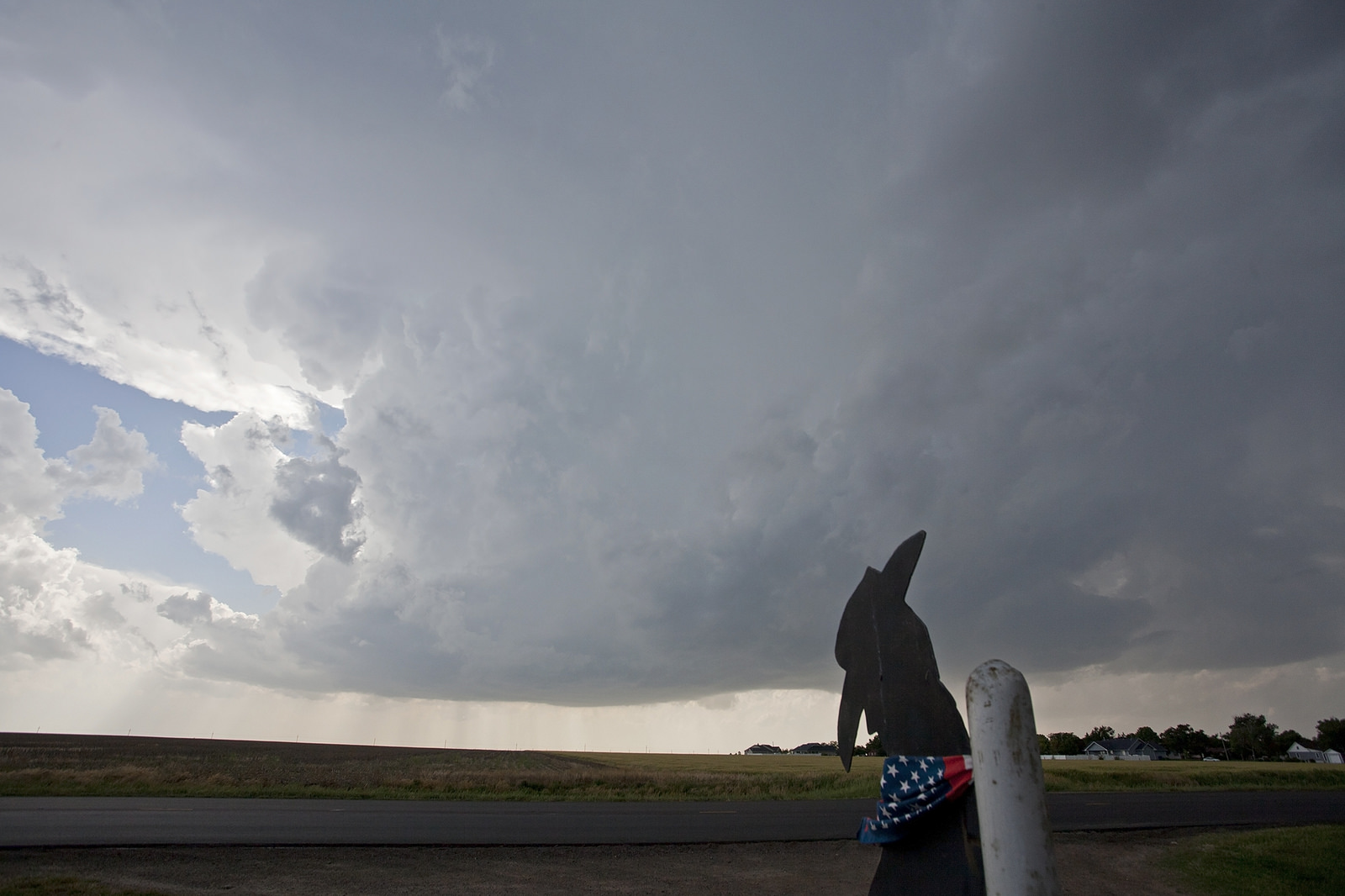
Next to the Minneola athletic complex, filled with that lovingly pampered baseball diamond, there was a steel cutout of a “lazy cowboy” bolted to the fence-post at the entrance. In many ways that cutout was our guide for the day.
We moved south to Minneola to put ourselves near or just north of an old outflow boundary/de facto warm front. This is an area where winds come together. This is good if you like storms because it helps cause air to rise and storms to form. It’s also good if you like tornadoes because it helps get those winds turning, which gets stuff a spinnin’.
In the middle of one of our conversations about various wedges (guide to wedges plus lesser tornado shapes) and lack of wedges this season as well as seasons of the past, I glanced at Twitter to see a gorgeous Wizard of Oz tornado churning across the western Kansas Plains about 60 miles to our northwest, bear Scott City.
https://twitter.com/ShyloNotShiloh/status/735221809482600448
This was a storm that was a shower about 45 minutes prior, so it was fascinating on many levels. It also made us at least a tad anxious. As a chaser you never want to see the action so close you could have been there, but too far away to realistically get to unless storms became atypical cyclical beasts dropping multiple long-track tornadoes.
If only it was closer…
The thing about memorable tornado days is most of them have multiple storms that develop and produce tornadoes. We tried to keep this in mind as we watched additional images stream in and we waited for a storm to form in our area. It was tough. Some people got impatient and went toward the storm. If they went quick enough they may have caught later tornadoes in its cycle. This storm actually formed near the tail end of the same boundary we were sitting on. Our environment was better, though.
We bit our lips, and we waited.
Go time
5 o’clock is about when the day’s increasing lateness starts to become a bother. If you don’t see development in your area of interest by 6 p.m., the situation really starts to become concerning. This is often for nothing, as some of the best days have come from storms that didn’t form until near or after 6 p.m.
Truth be told, in a lot of cases we want to bottle up the best for as late as possible, so it can interact with the daily wind flow changes that are natural to the Plains during spring. Sunset magic is one of the few “magics” in chasing that is entirely real. This is because the low-level jet stream increases near and after sunset as moisture streams north from its source region. However, as with this day, some of the most memorable days of all are basically done by sunset.
From 4 p.m. to 5 p.m., increasing signs of action were all around. The hazy sunshine above the waving wheat fields showed more signs of life. Clouds became taller. A few tried their luck and raced upward before getting cut off and dying. Such a dance of condensed water is common in the period before storms develop. It’s much like the early bubbles in a boiling pot that don’t really do much by the time they reach the surface. They come before the big pops.
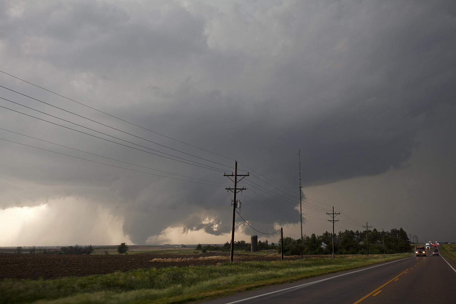
Raindrops began falling on our heads right around this time, and blips became bigger on radar. A storm was forming about 15 miles to our southwest and steadily developing as it headed northward.
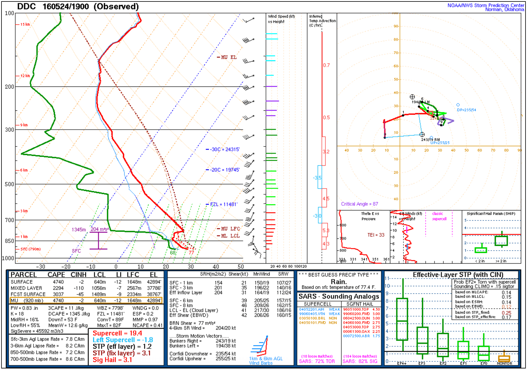
Given the environment, which was one characterized by strong instability values of about 4,000 to 5,000 surface CAPE, it was actually a little surprising the storm didn’t blow up quicker initially. What it may have been, and as with many storms of this nature, is some of the early developmental slowness is due to the need to consolidate multiple updrafts. As the storm which would become the prolific Dodge City supercell neared our position just south of Minneola, it was still fairly disorganized but beginning to take on structure. A low-hanging cloud report appeared to trigger a tornado warning, and the sirens blared.
Listening to the sirens I was reminded of the woman who had stopped to chat with us at the same spot several hours prior.
She noticed our little group of weather weirdos and inquired as to the likelihood of her son having baseball practice given the impending weather. We told her this area was fairly squarely in the risk zone, but maybe on the southern end of the highest threat at this point. Before heading on her way, she gave a quick description of where her house was in the town a few streets to the north, and what it looked like. If we needed a spot to take shelter, give a holler, she said. We thanked her as she went on her way and marveled about how caring folks in the region tend to be.
Now with sirens blaring, there was little to no chance we would be taking the woman up on her offer to take shelter at her house. Happily for her and the rest of her beautiful town, the storm was now drifting to its north, toward mostly open farmland between there and Dodge City, which was about 20 miles away.
Our home base of Minneola would be spared the tornado onslaught that was about to arrive. In the hours ahead the larger population center to the north would, however, face a scary period of time.
Quincy and I moved north with the storm. As he drove, I watched the bucolic fields of the central Plains blur by. I thought of the days prior, when this same area would have looked like a that default Windows background so many of us have had at one time on our computers. You know the one, blue skies with a few puffy white clouds and the greenest field you’ll see. Behind a cold front that swept tornado-friendly air well to the south, the fields were briefly kissed by deep blue skies filled with only the friendliest of clouds.
The same places were now on the verge of witnessing something much more sinister. Angry dark masses gathered in the sky overhead. Some began to swirl.
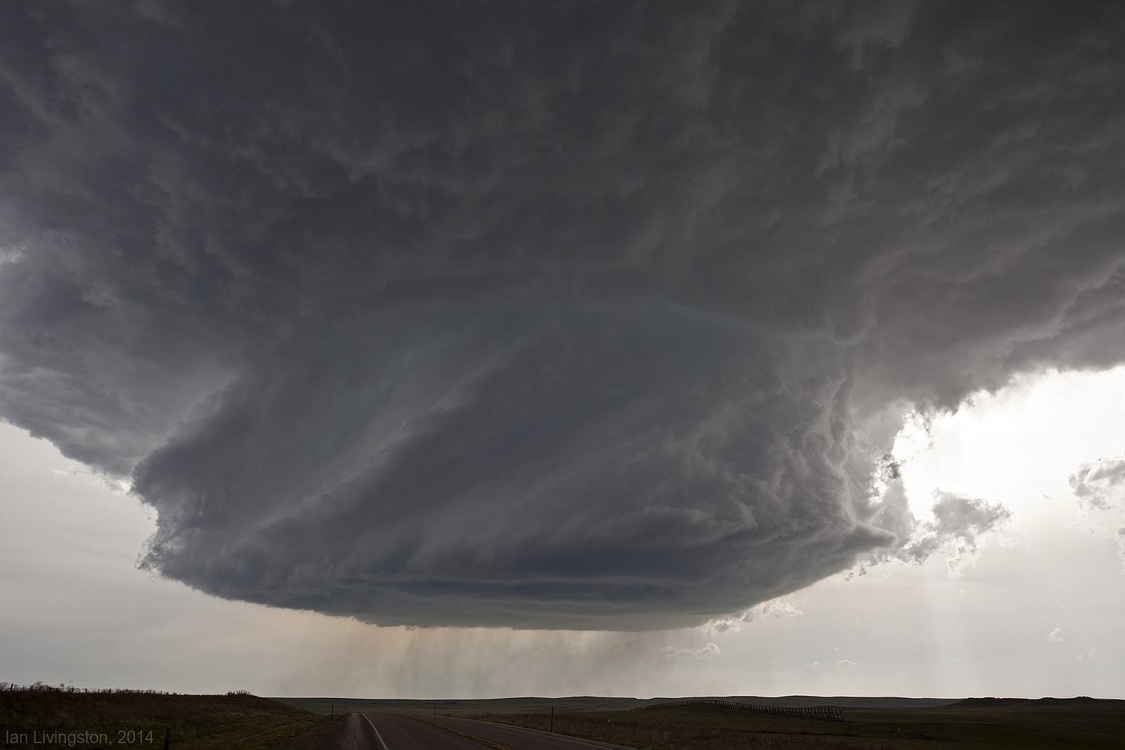
With the clock nearing 6 p.m., our storm had taken on quite a look.
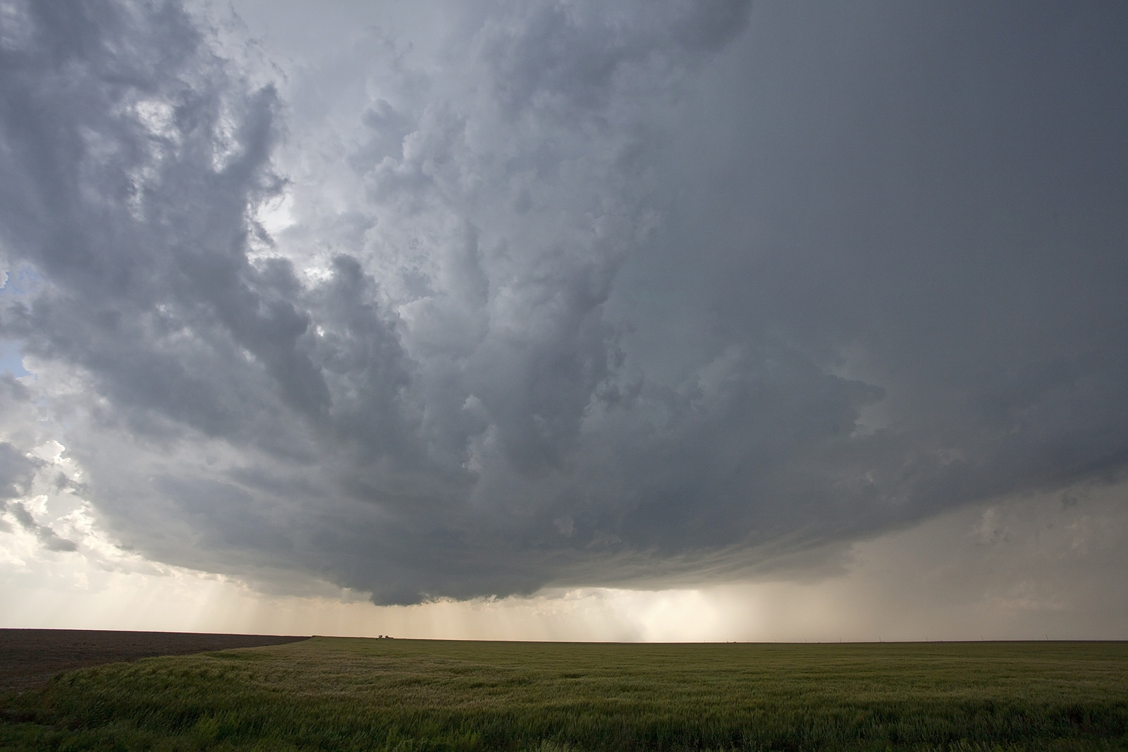
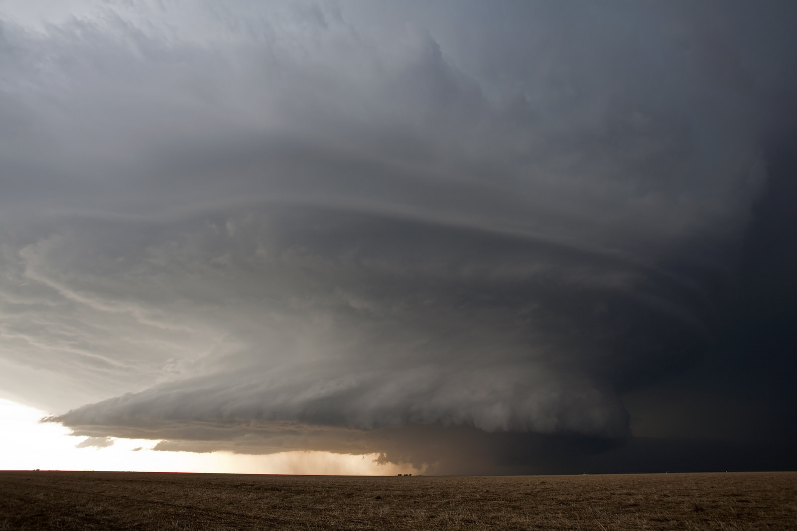
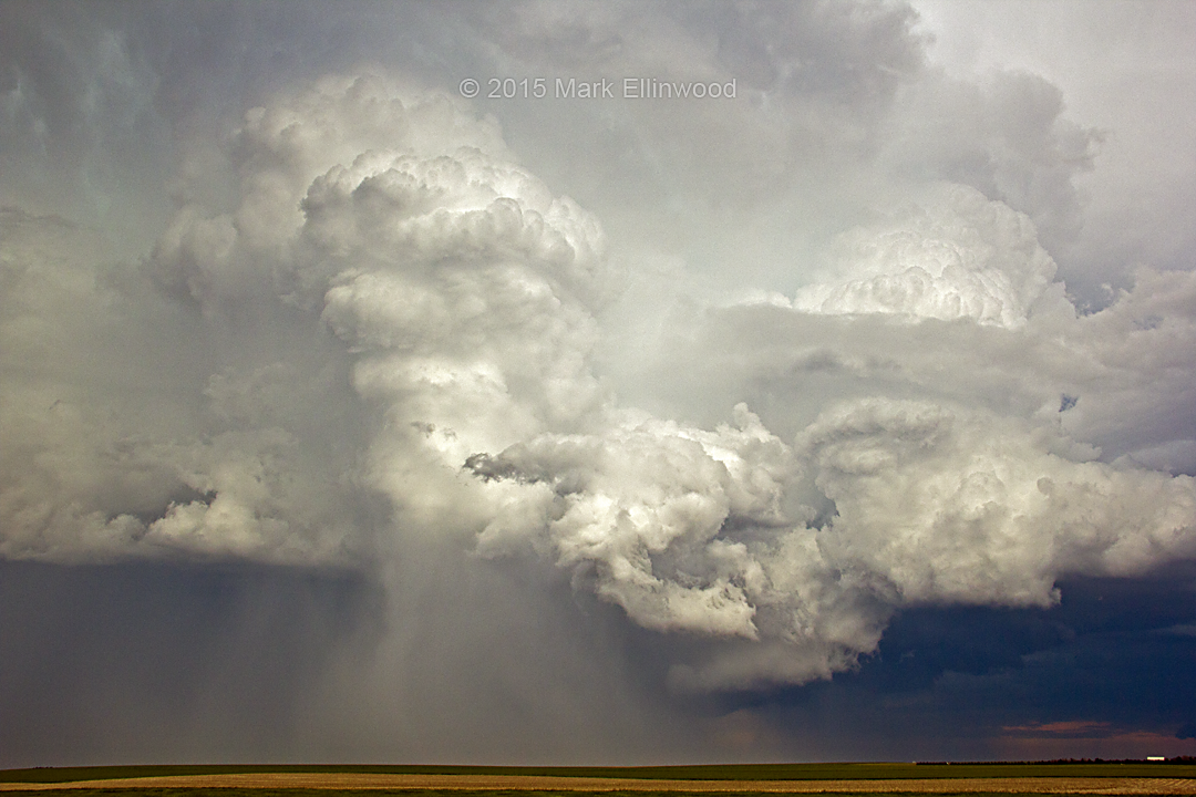
The consolidating updraft was now strongly rotating, striations in the cloud layers could be seen turning like a barber pole, from the base up to the heavens. The storm base was also flat and hard, a sign of a powerful updraft.
A cloud shaped like a baguette was eventually seen on the northeast side of the storm. This feature is often referred to as an inflow tail. It is witnessed on many of the finest supercells to wander the Plains.
With time, the supercell base began contorting into a bell shape. This is a classic sign of a storm about to try some funky things. Lowerings were becoming worth considering, as clouds took on the look of tornadogenesis.
After turning to the west and off of U.S. Highway 283 — the main thoroughfare between Minneola and Dodge City – we found ourselves about 7 miles north of our hangout from earlier in the day. Rotation in and around the still-lowering wall cloud continued to become more intense. Also known as a murus, a wall cloud is an area of lowered clouds attached to the updraft base. It’s often near the center of a supercell thunderstorm’s rain-free area. Wall clouds are often precursors to tornado activity.
The storm structure wasn’t anything incredible as far as structure goes. (I say that having not really seen it at its best, it was pretty amazing later) Whatever it was or wasn’t, it was a pretty storm, but we saw no reason to admire from afar for longer than necessary in the amazing terrain we were handed for the event. For the time being, as far as we could see there was a nearly perfectly flat and nearly perfectly treeless horizon. Game on.
In addition to the perfect viewing conditions, this part of Kansas — like a good chunk of the state — is made up largely of a tightly gridded road network. If you look at a road map in the Dodge City region, you’ll see a whole lot of north/south roads intersecting a whole lot of east/west roads. Zoomed out, you’ll see regular boxes created by the roads.
Watching satellite loops of convection forming never ceases to amaze me pic.twitter.com/blIuBfeFJh
— Dustin Conrad (@WxDcon) May 24, 2016
The smallest of those boxes contain outside line segments of about 1 mile. There are spots where this network is almost perfect for 10s of miles. Even in areas where it is not, the Kansas road network generally facilitates accurate and safe movement around tornadoes. It’s almost like they designed the road network for storm chasing knowing that Kansas gets incredible tornadoes. Almost.
Raining tornadoes
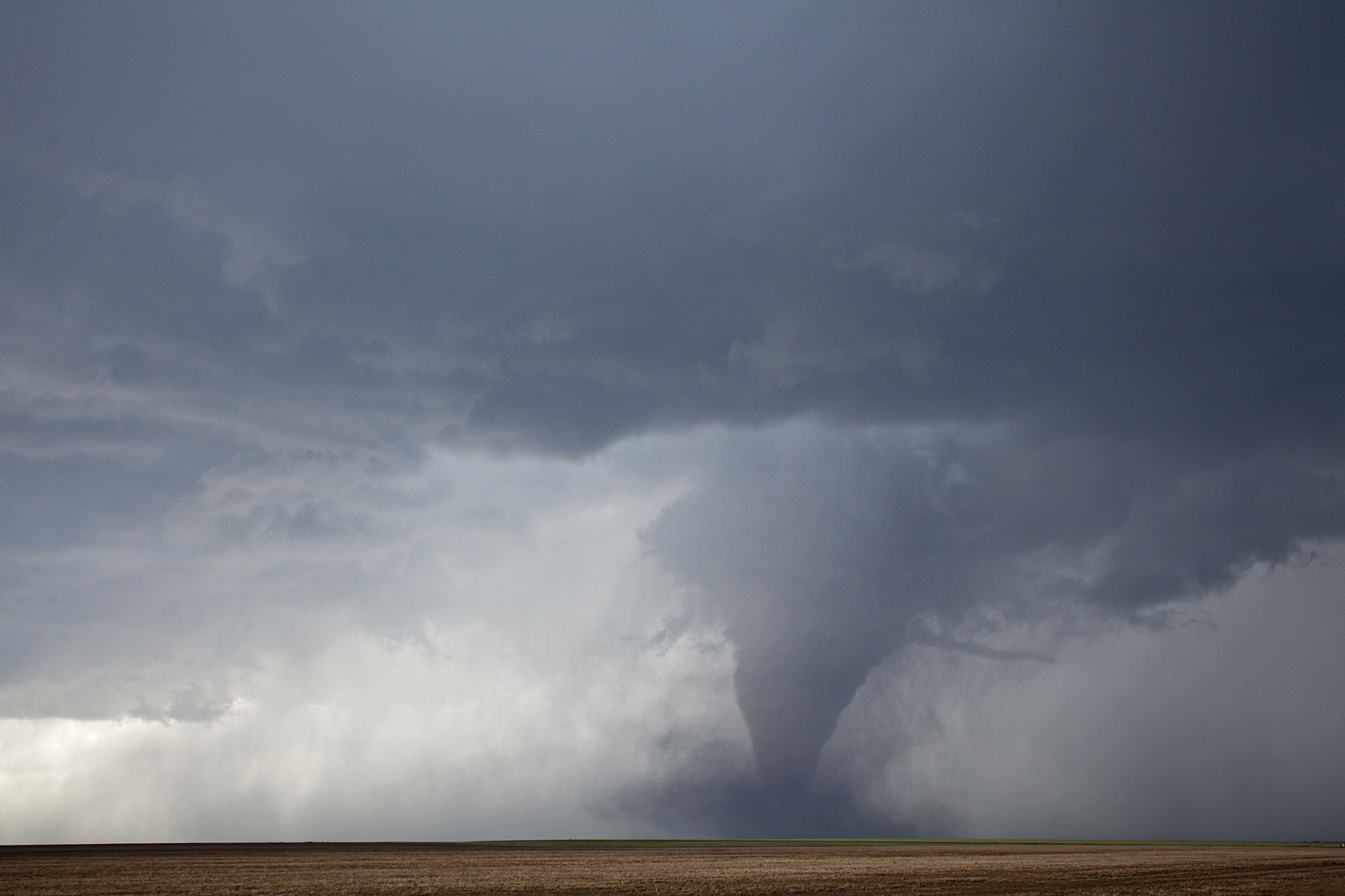
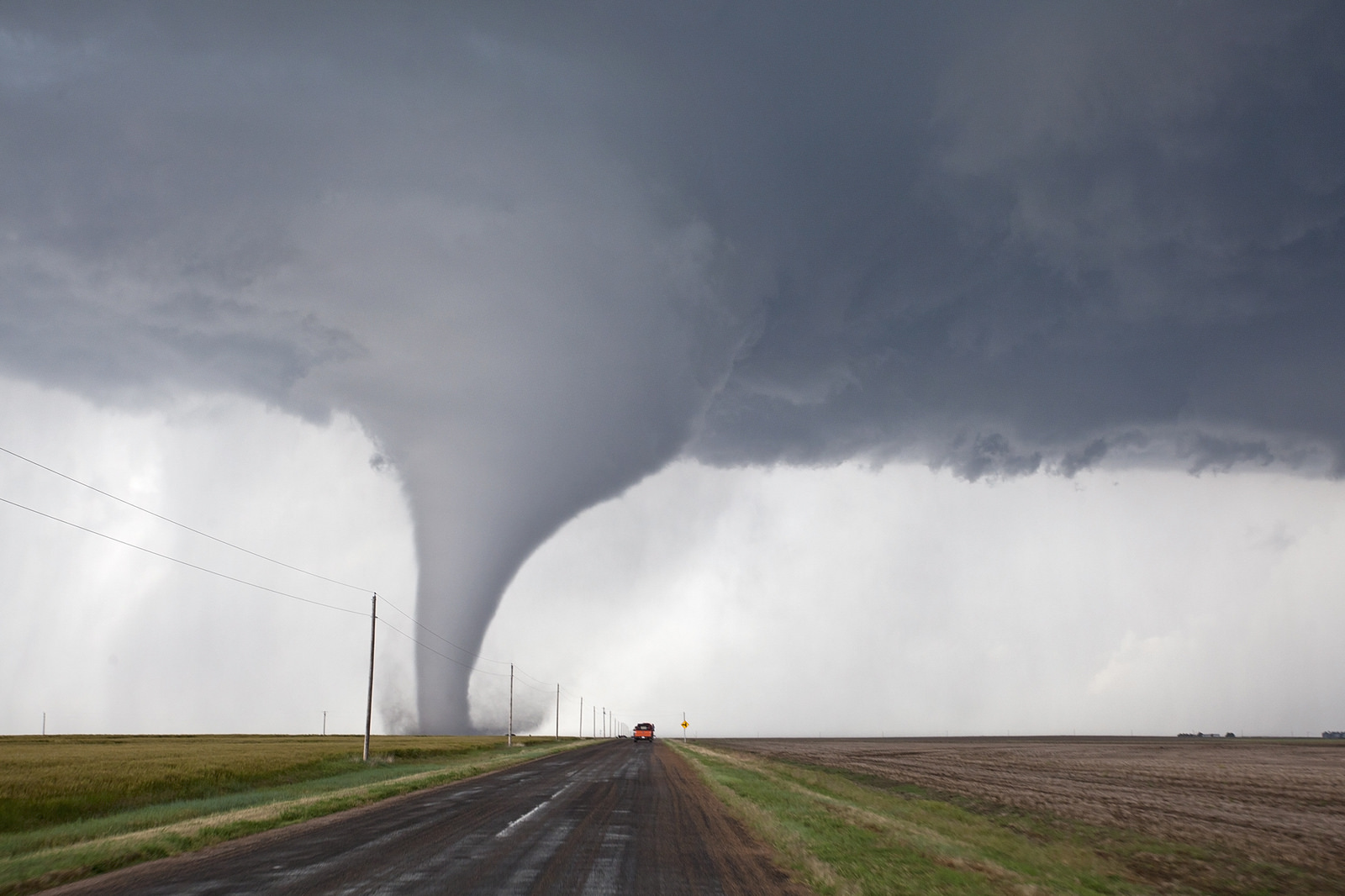
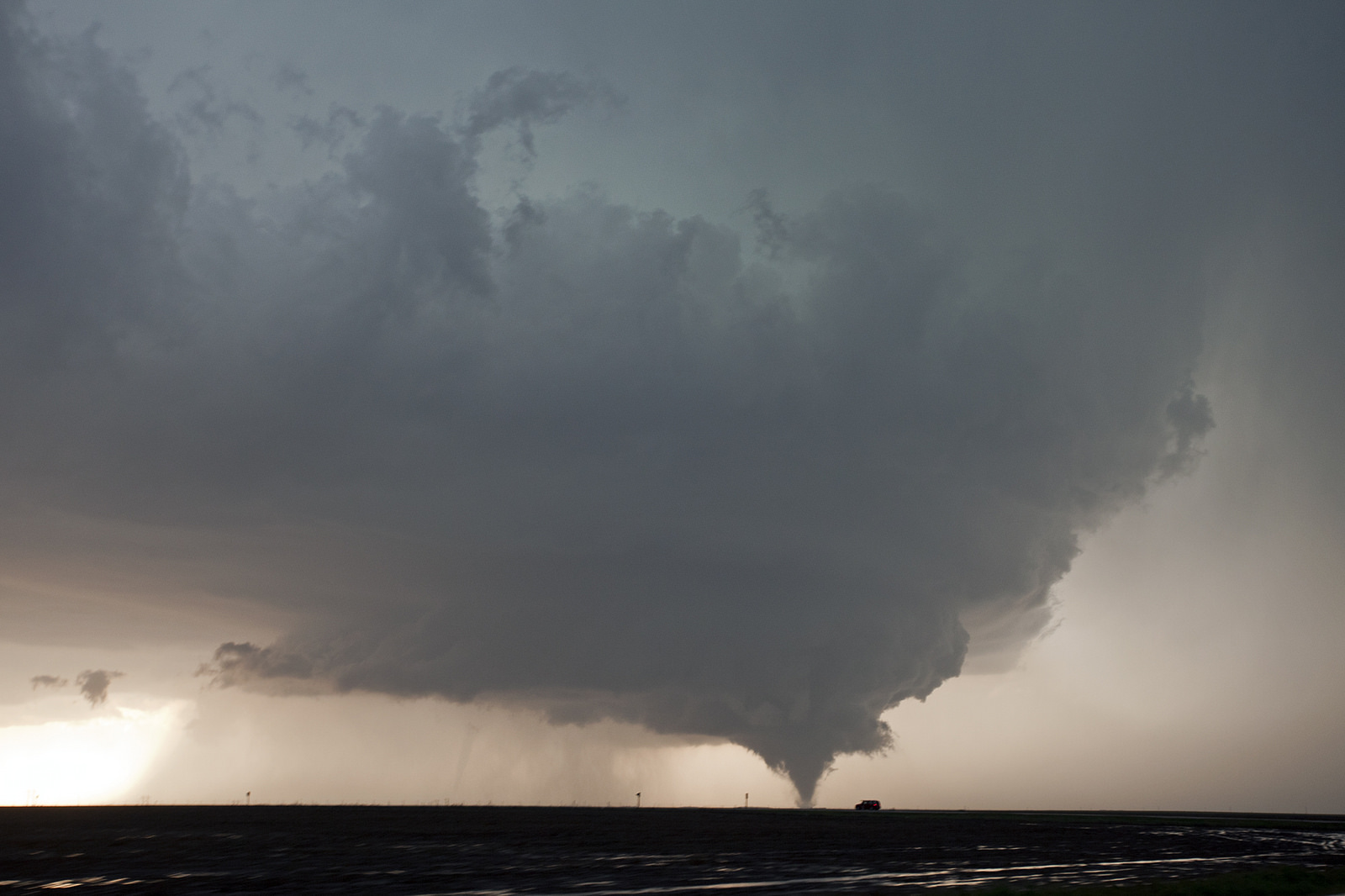
It was after 6 p.m. In front of us, a skinny elephant trunk shaped funnel cloud began to play tag with the ground below. At first it was just a swirl of dust several hundred feet below the condensed funnel above, you almost had to squint to see it. Eventually, a skinny and nearly perfectly vertical tube extended all the way to the ground.
Tornado!
It was getting going – ultimately it would be a fairly long-track event of 14.7 miles, and end up with an EF3 rating, which is among the stronger tornadoes on record. For the time being, it decided to rope out in a twisty Hollywood-scripted spectacle before coming back to life and firmly planting a few minutes later.
What do I mean by planting? In the first brief iteration of this tornado– they are allowed a short gap during a “skip” and can still counted as one — it was spindly, thin, and visibly tenuous. The reborn version of tornado number one was a different beast.
We allowed it to get north of us while inching closer. The make up of this storm, with a very high base as far as tornadic supercells go and little to no precipitation near the tornado, helped allow for a close approach with relative safety.
This day was the closest I have been to tornadoes. When you’re that close the rest of the world becomes a bit of a blur. Quincy and I were on a side road while much of the chaser traffic was on a the larger artery south of Dodge. We weren’t the only ones, there were at least a dozen or so chase vehicles on these side roads, all navigating in close range to the tornado.
At one point we decided it was time to hop out and grab some imagery from a non-moving vantage point. As nice as it is to be able to keep up with a twister in a vehicle, the images created from that vehicle are very rarely as good as when taken from a standstill.
Stand still is what we did. Right in front of some other chasers. Ooops. That time-lapse is going to hurt. And who was it? None other than the chasing superstar from Canada, Greg Johnson and his Tornado Hunters team. After a bit of friendly grumbling, we realized we were meeting each other in person for the first time. Frowns turned to smiles, and soon we were all back on our way.
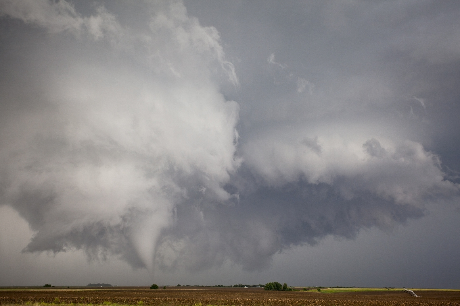
Trailing the tornado from the south, we watched it turn from a funnel shape that had a wide, almost boxed-in top, to a skinnier main trunk. It then morphed into a cone. Ultimately it would rope out, but not before becoming part of a set of “twins” as tornado two touched down in the new wall cloud to the east.
Given that the area between Minneola and Dodge City is almost entirely farmland, the first big tornado did not hit much. It did put on a huge and long-lasting show. The fact that it was just the start of the tornado barrage is still hard to process even after all this time.
Many of the fields in the area appeared to be fallow, or plowed but unplanted. This is a common practice to allow an area to rejuvenate following a previous crop. The first tornado of the day took advantage of that in a big way. For much of its life, this twister kicked up charcoal colored topsoil and tossed it about as it went.
Early in the cycle, the dust was reminiscent of darkly colored confetti dancing gracefully at the edges. With time, the skirt of dust grew into a great whirling mass that was three or four times the width of the base of the tornado itself. By the end of its life-cycle, with the rope out beginning to get underway, dust shrouded about two-thirds of the atypically tall tornado.
Coming in from the due south was perhaps the best way to play this storm, and that’s what we did. Usually, my chase team will tend to position ourselves further east, to the southeast of the typical hook that a tornadic supercell tends to produce. That puts us both a little bit further away from the tornado and it also puts us in a position that just about any movement of the tornado can be watched for a time with stress-free repositioning to follow. Given the high visibility of the day, the stress of watching was less than normal.
Another key aspect of coming in from the due south was that we could watch the cyclic wall clouds redeveloping to the right of the dominant circulation. On a storm like this, it was very important to keep an eye out for what was next.
The prolific Dodge City supercell made it clear quite early in its life that it just wanted to keep creating new tornadoes. Almost immediately upon tornado formation there was already sign of a freshly born and already rapidly rotating wall cloud to its east.
An inexperienced eye may not even notice this occurring until a tornado is forming or has already developed. It is one of the more significant dangers of chasing, and this kind of cycling in a supercell isn’t that uncommon, although this was an extreme case. It also made the option of being further east a little less desirable, because to be safest you’d need to be well east of both the original tornado and the new wall cloud.
The storm was churning away while we watched the new wall cloud just off to the right in front of us do its thing. Within minutes the second large tornado of the day was getting underway. It would be the fifth tornado produced by the storm, as several short-lived tornadoes developed concurrent with the first or shortly thereafter. The new tornado was about to put on a show for those of us close by as well as a whole horde of prime-season chasers across the region.
The whole cloud mass of the storm became quite low for a time during this process. It was tilted over as well. With both the present main wall cloud and freshly born tornado developing underneath, and the newer wall cloud in close proximity, the storm base seemed to churn like the gears of a finely-tuned machine.
The new tornado was still quite small at the base and the wall cloud above was so fat and low that the ground swirl didn’t even seem that imposing in itself. Nonetheless, the whole scene was moving. The clouds were tense and writhing. It was as unforgettable as anything I’d seen, and it was about to get better.
The first large tornado was to our northwest as we chased it from the south. Very early in our north pursuit it was just to our north, but once we got close enough to stop we eventually let it drift its own way while enjoying the view and keeping an eye out for new developments. The new developments were now just to our northeast. It was apparent that it wouldn’t stay that way.
What became the second large tornado eventually went on to shed its big and bulky wall cloud as it wrapped up into a magnificent white tornado. Much like its predecessor, it wasn’t long until this one started to kick up dust.
You need a special kind of light for a white tornado. You need a special kind of terrain to take full advantage of your positioning options. To fully harness either of those things, you need some luck to even get a fully condensed tornado to begin with. Here, we were witnessing something atypical come together, and doing so from very close range.
While tailing the developing tornado we got quite personal with it.
Since it developed to the northeast and was moving north and northwest, it was likely that the tornado would cross our path at some point. As it began its slow crawl toward the road we were on, we watched several smaller tendrils extending out of the new wall cloud that had formed to the east.
Quincy got us up close. I was ready to stop. Then he got us closer. I briefly and half-heartedly protested, but I also knew that the tornado would have to do some really weird stuff to threaten us at this angle, so I agreed to push forward. It was worth it. With full honesty, and in retrospect, I wish we had gotten even closer.
I jumped out of the car into a light rain. The circulation center of the mesocyclone remained incredibly rain free, but every now and then it spun a thin curtain around itself.
A half mile in front of me I watched a chunky and laminar tube cross the road. The lowering evening sun ducked below the clouds just enough to make the tornado glow. Like the first large tornado of the evening, it kicked up dirt as it swished through the fields of western Kansas. Instead of the very dark topsoil the previous tornado found, this dirt was redder and less dense. Eventually it would wrap itself up the sides in something of an ornamental display of nature’s wildest winds.
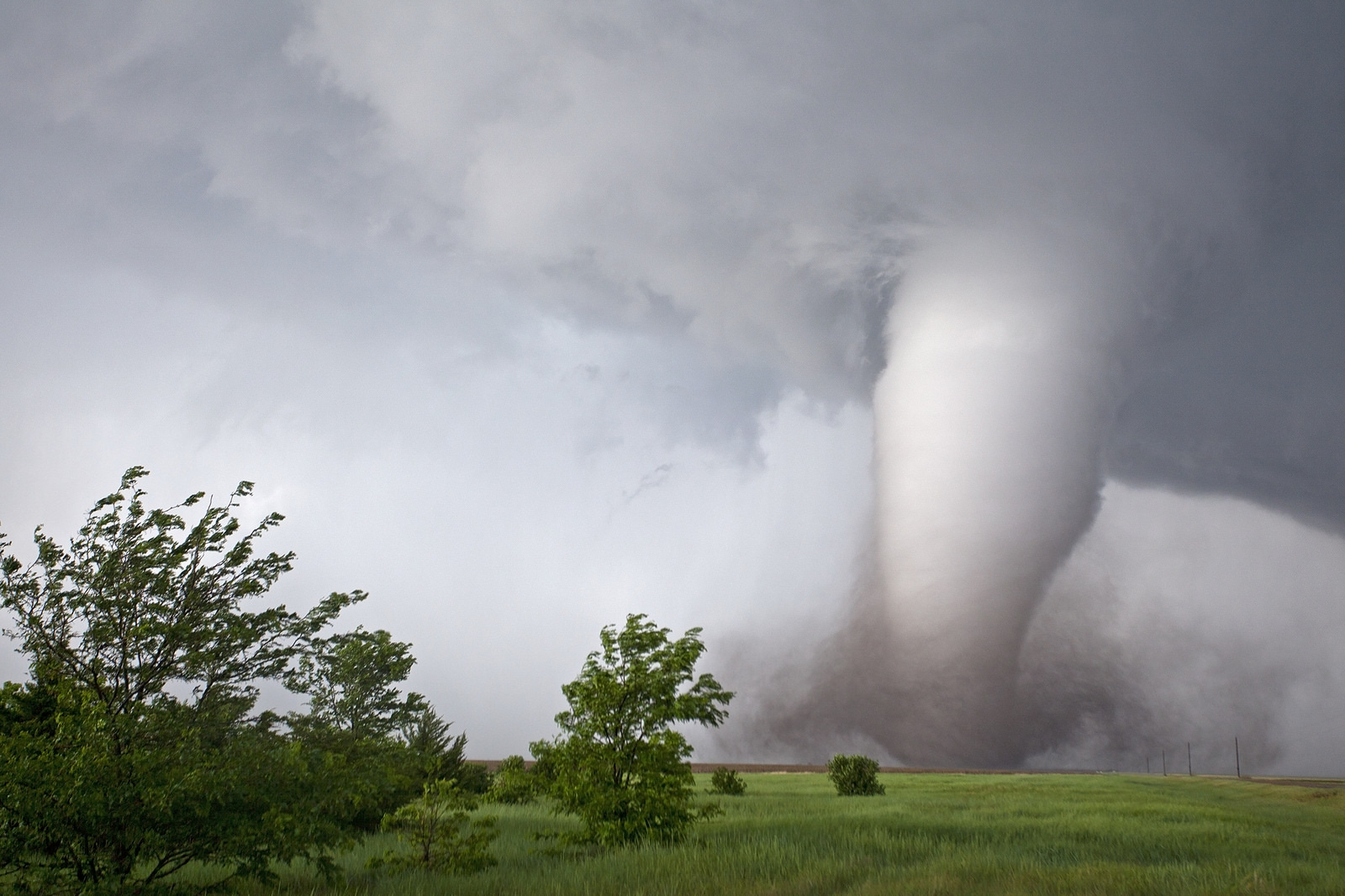
There are stories about tornadoes sounding like trains for as long as there have been tornadoes and trains. It’s possible that some tornadoes sound like trains, although I have spoken to several people who are generally dubious of the claim. One thing is certain though, a tornado that runs into an industrial park is going to sound different than one churning through fields of wheat and dirt. This one was dropping jaws and hitting nothing as we watched it.
Seasoned chasers will tell you that the sound a tornado makes is more like a waterfall. Take a listen (tornado|waterfall). You can debate the timbre, like my girlfriend when listening along with me, but it’s true. She’s right that the pitch is slightly different. There are very similar qualities.
A waterfall is a peaceful sound, but that’s mostly because we associate it with a peaceful activity. In reality it is water cascading endlessly over jagged rocks. The result is a roar of varying intensity. It’s a droning noise, one that many even say brings a sense of calm.
It’s hard to imagine the same with a tornado, even as a chaser – until you hear it. Even getting within a mile or two of a few tornadoes in the past, the waterfall was a sound I never heard a tornado make.
For several moments, I stood there with my camera at my side, simply in awe of what was going on in front of me. If I closed my eyes I could pretend I was back in my old home of northwest Connecticut, standing at the edge of any of the various waterfalls there. Just listening. Taking it all in.
@islivingston @stormchaserQ y'all really shouldn't be chasing violent tornadoes on foot like that 😉 pic.twitter.com/dyUidYlm9f
— Stas (@StasisChasing) May 25, 2016
In no major hurry to move, and otherwise blocked by the local sheriff, we watched the majestic glowing tornado move away to the north. A second tornado touched down to its east, at least the third instance of multiple tornadoes on the ground at once from this storm. It was not the last time, either.
As the second larger tornado began to head toward its demise, cloud bases above it were once again very high. This was an extremely tall tornado. While it roped out, it performed some acrobatics that remind you nature can pull off things that feel like they could only be imagined. The tornado became skinny and wire-like, but the base danced around as if it was unconnected to the rest, without a care in the world for its path.
And when it was over, it wasn’t really over. Not with this storm.
A close call as we bypass Dodge
Given that we were halted by local law enforcement, and that we had already been playing with tornadoes for about an hour, which is a huge amount of time for any one chase, we took it a bit easier for the rest of the event. Another factor was that the storm was now impinging on Dodge City. Feelings start to change as these dangerous winds aim themselves at population centers.
Dodge City is not a huge place by any means, but it’s large for the Plains. With a population of almost 30,000 people, being in the way of a storm with a history of large and destructive tornadoes is never a good thing.
As we tailed the storm, a huge wall cloud approached the southwestern part of Dodge City’s outer-limits. It appeared the storm was about to “wedge out” any minute. Sometimes this happens almost instantaneously, when basically the whole wall cloud contacts the ground and becomes a wide and potentially devastating tornado.
At 6:41 p.m., the city and its residents were put under a tornado emergency. Dodge City NWS knows big tornado events, and this was one.
The text of the warning called it a “life threatening situation,” noting that when it came to homes, businesses, and vehicles, “complete destruction was possible.” The tornado did briefly turn into a wedge. At one point this tornado’s width was up to a mile wide. It was on a path toward Dodge.
Thankfully, the storm motion of the day was northerly and even a bit northwesterly over time. The tornado started a bit west of due south of the city. That initial placement would be important down the line. In the end, the widest and lengthiest tornado of the storm, one rated strong even without hitting much, would get no closer than 2 to 3 miles west of the main part of the city.
There’s always a question of what to do when you enter populated areas as a chaser. Some folks chase into and near cities. I’ve always run with crews who are generally against that idea.
When you’re chasing, you should always have a sure-fire out. You want to control your destiny as much as possible. You should also want to not cause harm, and part of that is generally staying out of the way of local life as much as possible. From talking to them during our travels, the people of the region mainly want us to enjoy what it has to offer, taste its great food, sleep in its lumpy roadside beds, and have a good time. But they don’t want us in their way when they are in danger. As chasers, we should respect and understand this. While we don’t want to see disaster, the act of chasing can put us into disaster. Cause no harm.
That’s a long way of saying instead of running through Dodge City, we went around it. And when I say around, I mean the long way.
From the end of the second large tornado and during the new ones that got going after, we were generally at least 5 to 10 miles away from the rest of the day’s activity. Thinking back, we probably should have just waited for the roadblock to clear and then followed the tornado north. It’s typically a lot more difficult to see things 100 percent clearly while in the act of chasing as opposed to after. Now, looking at maps, I can say “well, we could have stayed closer.” But then, and how you should always be thinking in pursuit, playing cautious is usually wiser than going all in without thinking.
In a lot of ways, staying back for the rest of the storm was a treat. After the storm rained tornadoes for an hour, it also became more of a visual spectacle from top to bottom.
It was chunky and signs of great rotation were all over. It had several vertical layers.
Over time, it was as if the storm would lean forward. This appearance was partly due to the continual reformation of the wall cloud out ahead of the current tornado. It was a reason for the multiple instances of more than one tornado at once. There were at least four to five pronounced reborn mesocyclones with this system. A cyclic monster.
As the supercell climbed north of Dodge City, it dropped another EF3 a few miles north of town. The tornado was a classic cone as the old tornado roped out to its west. Above the tornado, a sleek structured cell continued to head north. A green glow at its top signaled the presence of hail. It was a striking contrast to the increasingly warm colors of the late-day sun shining below the relatively isolated storm.
Nearly an hour and a half after it started producing tornadoes, the end was a reality for the prolific Dodge City area supercell. While the supercell moved north of the city, other storms began to vigorously explode across the area. Several of these other storms also ended up dropping tornadoes.
Even as the last tornado of the cycle danced away to our north, the updraft of the storm was a work of art. It almost appeared to be a large spinning top. One thing that helped set it apart visually was a great “knuckled” cloud reaching skyward. The updraft was still well developed, and the storm wasn’t going down without a fight. For a time, twin tornadoes again played on the horizon. Within minutes, the process would finally end.
Afterglow
Chasers are so connected to technology these days it sometimes feels like it’s a different “sport” than that which people describe from the past. In the lead-up to storms it can seem as if you are back at home on your computer chasing from there. Almost everything you can geek out over at a personal computer is now available on the go. And everything is available. In 2016, we chased entirely on iPhone, without problem I might add.
The weird thing was during the whole tornado cycle I think I glanced at radar once. It was after the second large tornado and in the high of our close encounter with the waterfall. I thought to myself, “you better grab an image with your location just to prove this was not a dream.”
This was a visual chase. Even though I’ve been chasing for six years in the Plains, I was still somewhat surprised how little we checked radar while the action was ongoing. We knew the setup, and we watched the clues. In many ways, that allowed us to get right up to the early tornadoes. If we had our noses buried in radar, we might have been dawdling too much to do so.
Visual chasing isn’t something I’d necessarily recommend to anyone who is new to chasing, but it is perhaps the ultimate goal of chasers once practiced. I look forward to the next time.
Even the day after we didn’t just visual chase, and that highlights an important aspect of chasing, one which needs to be noted here. We visited Moore after the EF5 in 2013 for the simple fact of seeing it firsthand. Respecting what we chase is critical. Situational awareness can actually be the difference between living and dying.
The day after this chase, we found ourselves face-to-face with a large and violent tornado in terrain that was not nearly as favorable. There were river valleys, there were winding roads, there were trees. We played the day totally differently. We hung back. We enjoyed the structure. We ran way out ahead of the tornado, never to see it again, once it started to get into a window where our paths would eventually cross and we no longer had the large margin of safety we wanted.
Even in perfect chasing terrain, things happen. Our visual selves eventually checked radar and saw the storms that had erupted all around us.

Running back south we were immediately pounded by large hail. I rarely shoot video, but I pulled out my iPhone and prepared it for the eventual stone that would break the glass. That stone never came. I actually don’t know how big the hail was, or how close we came to breaking the windshield. Hail is loud. When you are driving through it at any speed it becomes deafening. Each pelt feels like it could be the one, even with stones too small to leave a dent.
While the hail didn’t end up doing anything to us, it was a reminder that even in the middle of our perfect chase, mistakes could be costly. Chasing is not nearly as dangerous as some like to claim, but it is a high-stakes adventure, and poor decisions can haunt you in many ways.
Quincy ultimately got us free of the storms over the western portion of Dodge City. We were still sitting under big anvils. They covered the state after multiple supercells went up and sent moisture into the upper reaches of the atmosphere. These anvils were producing some lightning even outside the rain. They were being lit from beneath by the sun preparing to set over the western Kansas prairies.
In our post-tornadofest euphoria we decided it was a night to eat before 11 p.m. Quincy and I met up with Dan Gottschalk and Kelly Lange, chasers from Iowa and long-time friends of Quincy. Our buddy Paxton also wandered in with 100 of his closest friends.
In a lot of these places, some still feeling like western outposts, there isn’t a whole lot of food option around. People tend to congregate. On this night, it was the Applebee’s of Dodge City. There were even Reed Timmer sightings.
Clearly the first set of us to arrive wasn’t thinking clearly, because soon after sitting down, rumors started trickling about the scene unfolding outside. Remember those anvils? They were now glowing in sunset light. Oh, they had bumpy mammatus clouds all lit up as well, making the scene an unforgettable one.
I glanced out the window and knew I needed to snap at least a few shots. Mine were nothing special. A few had the Applebee’s sign in them! I forgot that I had eaten there before, and that old-town Dodge City was a few feet away. If I remembered that, I would have wandered that way for a cooler grab. Some people were still out chasing, like good chasers would. They got amazing stuff. Others hit parts of historic Dodge for the stunning view.
Whether or not my image of glowing mammatus won the day – and for the record, it most certainly did not — I was happy to see it. It capped a day of pure brilliance from start to finish.
There are days we miss while chasing that are painful as a chaser, but they also keep the dream alive. I think of ones like the Simla, Colorado tornadofest of 2015 as perhaps my greatest example. It pained me for a year after it happened. We chased the High Plains for days and days prior, only to be lured by Kansas on that day. Of course, Colorado went big and the best event of the year occurred while we were a day or less drive to the east.
Now I’ve seen the big one. The kind of day we dream of. It was my best chase day ever, and undoubtedly the same for others. Does that mean I’m done? On the contrary. I’m already wondering how I will top May 24. One thing that keeps us coming back is that we know there is always a chance for another “best chase day ever” to be had.
Please consider this post a draft in progress. Changes, including significant additions or deletions, may occur.
Latest posts by Ian Livingston (see all)
- Tornado outbreaks: April, May and June peak-season primer - April 27, 2025
- Busy March for twisters to end with another multi-day event - March 28, 2025
- Everything but locusts: NWS shines in apocalyptic weather - March 17, 2025
Thanks for the memories Ian. Dodge City was amazing. Like 20 chases rolled into one, it kept serving beyond expectation. Right down to the very end with a brilliant display of anticrepuscular rays. I swear Dodge City looked more like OZ beaming under a celestial crown. The whole thing was surreal. We transitioned back to reality under a boiling sky of mammatus, sitting in our car trying to process what we’d just experienced. Chasing is just about being in the right place at the right time and the reward we get intense but brief for the effort expended. Dodge City defied the norm by delivering in spades. I’ll always hope for another Dodge City, but remain content if Dodge City stands out as king among chases.