While there are almost daily tornado threats in the central U.S. over the course of the next seven days, the overall tornado count will be on the low end, with storm mode and moisture issues keeping tornado activity limited.
1-3 Day
Thursday – East-central Plains, western Midwest
NUMBER OF TORNADOES EXPECTED: 2-5 – CONFIDENCE: Normal
Tornado Hot-spot: None
Pros: Low to moderate instability, good speed shear, decent/good directional shear, decent/good upper-level dynamics.
Cons: More linear storm mode along the cold front in the western parts of the risk area, hints of backing winds in the mid-levels across the western part of the risk area, extensive cloud cover over the eastern parts of the risk area keeping instability limited there.
Thursday – ArkLaTex
NUMBER OF TORNADOES EXPECTED: 1-4 – CONFIDENCE: Normal
Tornado Hot-spot: None
Pros: Moderate to high instability, good speed shear, good low-level directional shear.
Cons: Mostly linear storm mode, unidirectional mid-to-upper level winds, weak upper-level support, storms expected to die off in the evening as capping issues develop (with the exception of central Texas, which will have new storm development in the overnight hours).
Friday – Southern and eastern Texas
NUMBER OF TORNADOES EXPECTED: 1-4 – CONFIDENCE: Normal
Tornado Hot-spot: Southern Texas
Pros: Low to moderate instability, decent/good low-level directional shear, decent upper-level support.
Cons: Mostly linear storm mode, poor/decent low-level speed shear, potential for backing mid-level winds in eastern Texas.
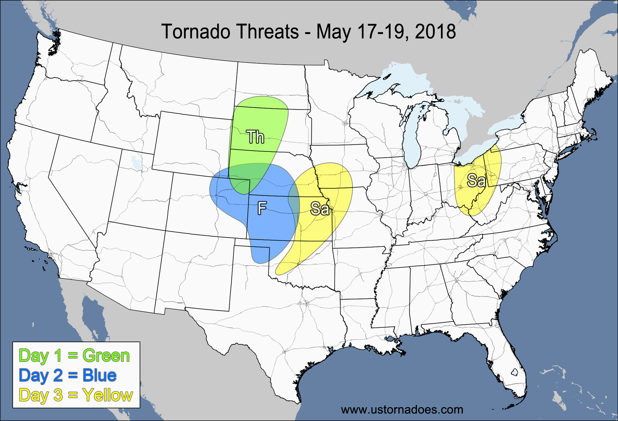
Saturday – Northwestern Midwest
NUMBER OF TORNADOES EXPECTED: 0-2 – CONFIDENCE: Normal
Tornado Hot-spot: None
Pros: Decent low-level directional shear, decent opportunity for landspouts.
Cons: Low instability, unidirectional mid-to-upper level winds, questionable low-level moisture, weak/decent upper-level support.
4-7 Day
Sunday
No tornadoes expected.
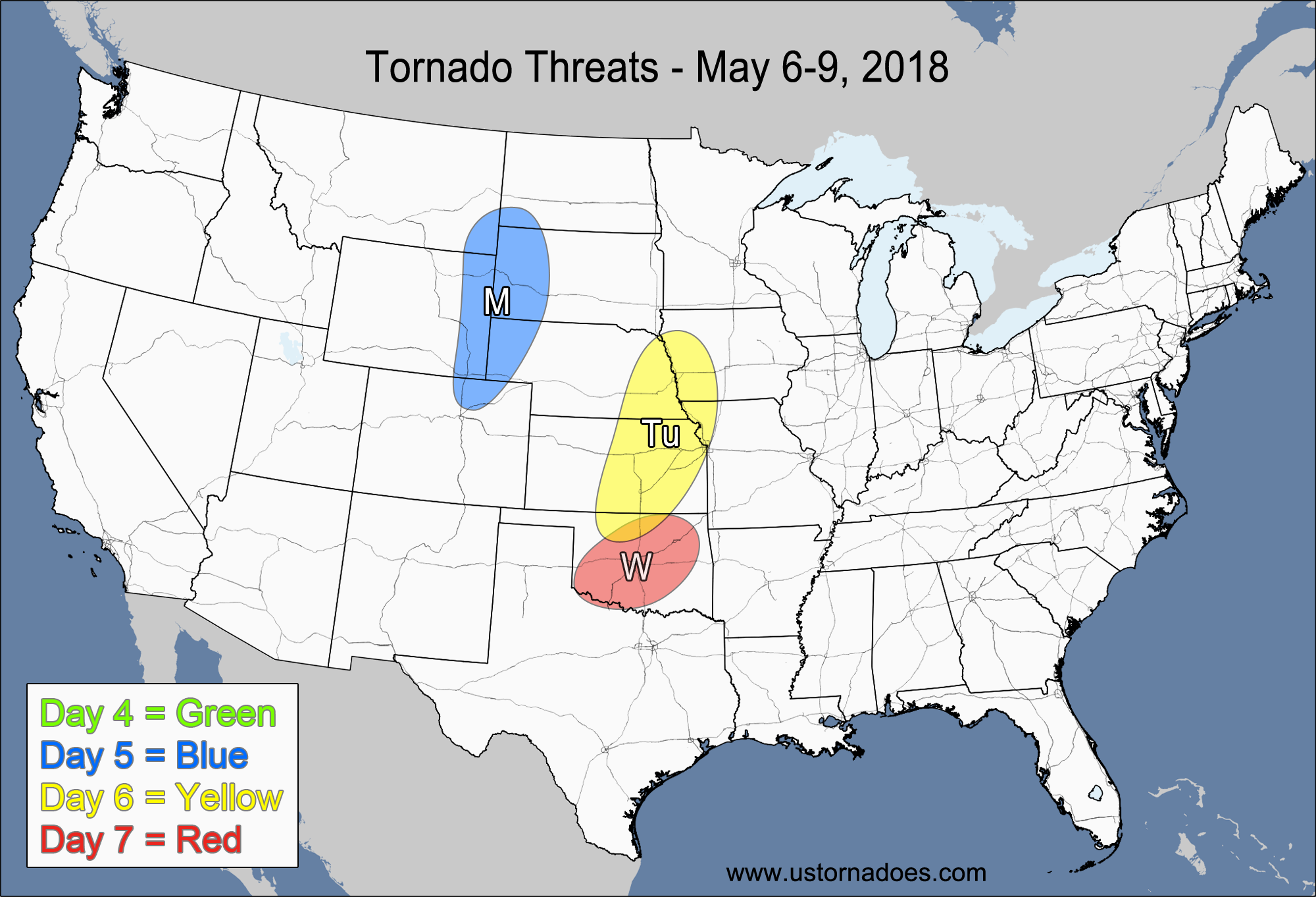
Monday – Northern High Plains
NUMBER OF TORNADOES EXPECTED: 0-3 – CONFIDENCE: Normal
Tornado Hot-spot: None
Pros: Good directional shear, decent/good speed shear, decent upper-level dynamics.
Cons: Low instability, questionable low-level moisture, high LCLs, capping issues in the evening.
Tuesday – East-central Plains
NUMBER OF TORNADOES EXPECTED: 0-3 – CONFIDENCE: Low
Tornado Hot-spot: None
Pros: Low to moderate instability, decent/good low-level directional shear, decent upper-level dynamics.
Cons: Unidirectional mid-to-upper level winds, rising heights in the southern parts of the risk area, storms could quickly become elevated in the evening.
Wednesday – Oklahoma
NUMBER OF TORNADOES EXPECTED: 0-3 – CONFIDENCE: Low
Tornado Hot-spot: None
Pros: Low to moderate instability, good/excellent directional shear.
Cons: Poor/decent speed shear, low storm coverage.
Latest posts by Mark Ellinwood (see all)
- Spring 2023 seasonal tornado outlook - March 1, 2023
- Spring 2022 seasonal tornado outlook - March 1, 2022
- Spring 2021 seasonal tornado outlook - March 1, 2021