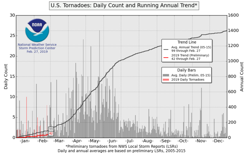
Following a quieter than normal tornado year in 2018, the start of 2019 seems to be continuing on a similar track, with a tornado count that is somewhat below normal to-date. This said, minimal tornado production is certainly not unusual so early in the year.
The outlook for the next several months offers some upside potential for tornado activity with time. It may also be a sputtering start to the heart of the season for a number of reasons.
A series of storm systems in early March will keep the Plains states out of the running in terms of tornado potential, but Dixie Alley could face multiple tornado threats over the next two weeks as potent weather systems traverse the region and try to tap into early-season Gulf of Mexico moisture. How much moisture and instability these storms can gather over Dixie Alley is the big question in fostering any systems with tornado potential in the near future.
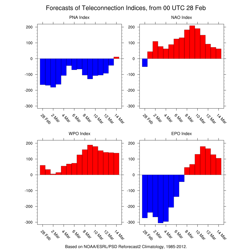
A combination of -PNA/-WPO/-EPO indices tend to favor troughing (or a buckling of the jet stream) in the western U.S., which allows storm systems to dig further south into the western half of the country.
The combined +AO/+NAO should also aid the other synoptic patterns in eventually bringing warmer than normal temperatures into the southeastern U.S.
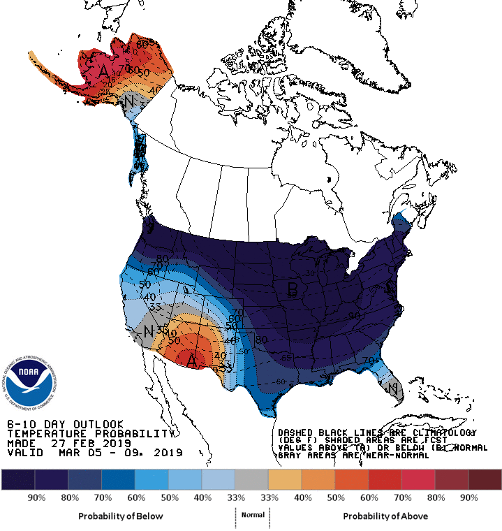
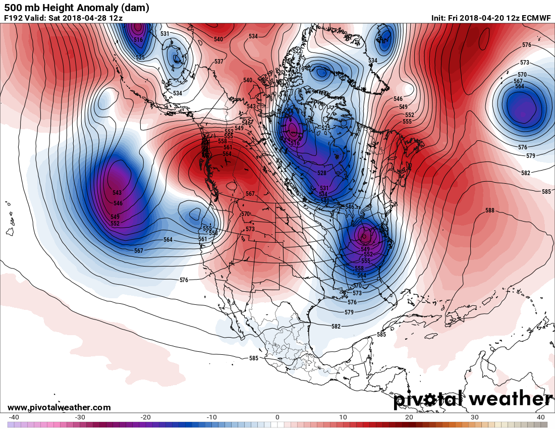
However, with all this in mind, each of the upcoming storm systems appear to have strong pushes of cold air in their wake. As shown above in the forecast from the Climate Prediction Center, cold air is likely to dominate the Lower 48. Repeated cold fronts will work to suppress Gulf moisture from lifting northward, which likely limits the tornado potential through mid-March. Short warm-ups and brief periods of moisture return should ensure that each disturbance won’t have that much fuel to work with.
[Past seasonal outlooks, starting in 2013]
With the exception of the PNA trending more neutral by mid-March — which generally means less troughing over the western U.S. — the other indices tend to indicate that as we head into the back half of March, cold fronts should stop diving as far south, allowing for more Gulf moisture to enter the southern U.S. As a result, we could see tornado activity pick up more notably across the South during the latter half of the month.
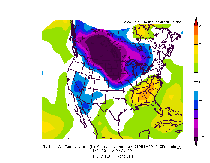
Comparing the March forecast with the temperature pattern through the start of the year, it appears that March will be continuing the overall trend of colder air over the north-central U.S., with warm anomalies in the southeastern U.S.
Overall, it seems March could end up with a quiet-to-normal first half and a near normal second half, resulting in a slightly below normal tornado count for the month. However, given how the recent pattern has yielded quieter than normal tornadic activity, I could see the back half of March ending up with less tornadoes than expected.
Heading into April and May, we rely more on other indicators, such as
El Niño-Southern Oscillation (ENSO), Pacific Decadal Oscillation (PDO), and Atlantic Multidecadal Oscillation (AMO), as well as drought conditions.
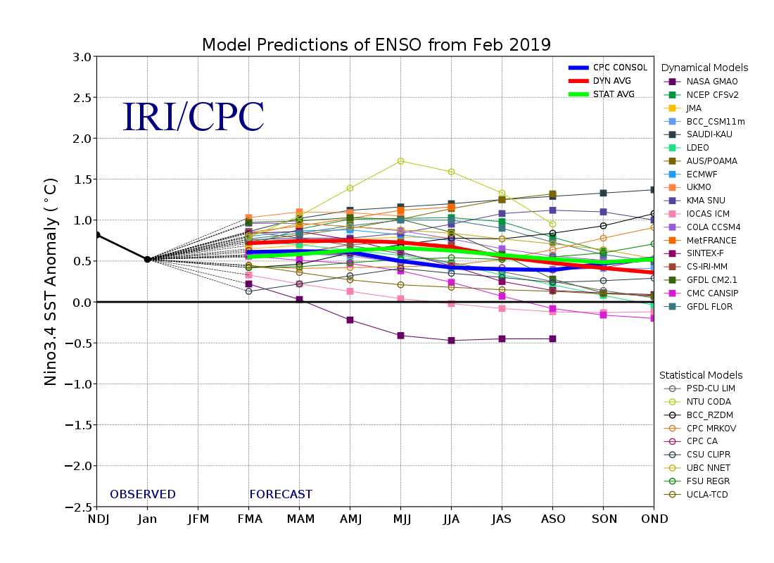
There is currently a weak El Niño ongoing, which looks to continue into the spring months. For the March-April-May period, the El Niño pattern tends to favor slightly cool anomalies across the Southwest and the central U.S., with wetter than normal conditions in the South. There are also hints that El Niño conditions help bring a more back-loaded season, though that seems to only pertain to stronger Niño events, so it will not be considered much overall.
The weak Niño conditions appear to play into the shorter-term indices that we checked out for the March forecast, so we could see the mid-to-late March trends hold deeper into the spring season.
Let’s see if we can find some better correlations with the PDO and AMO.
Recent monthly PDO values have been leaning toward the negative side, but not dramatically so. The near-term negative-PNA pattern should help reinforce the cooler sea surface temperature anomalies over the eastern Pacific Ocean in the coming weeks, so we can generally assume that the PDO will continue to lean negative as we head into the middle to later parts of spring.
The negative-PDO generally helps reinforce cooler than normal temperatures over the western U.S., which implies that more storm systems will favor a more southern track in the western U.S. As a result, these storms have a chance to draw greater amounts of low-level moisture and warmer temperatures into the central and eastern U.S.
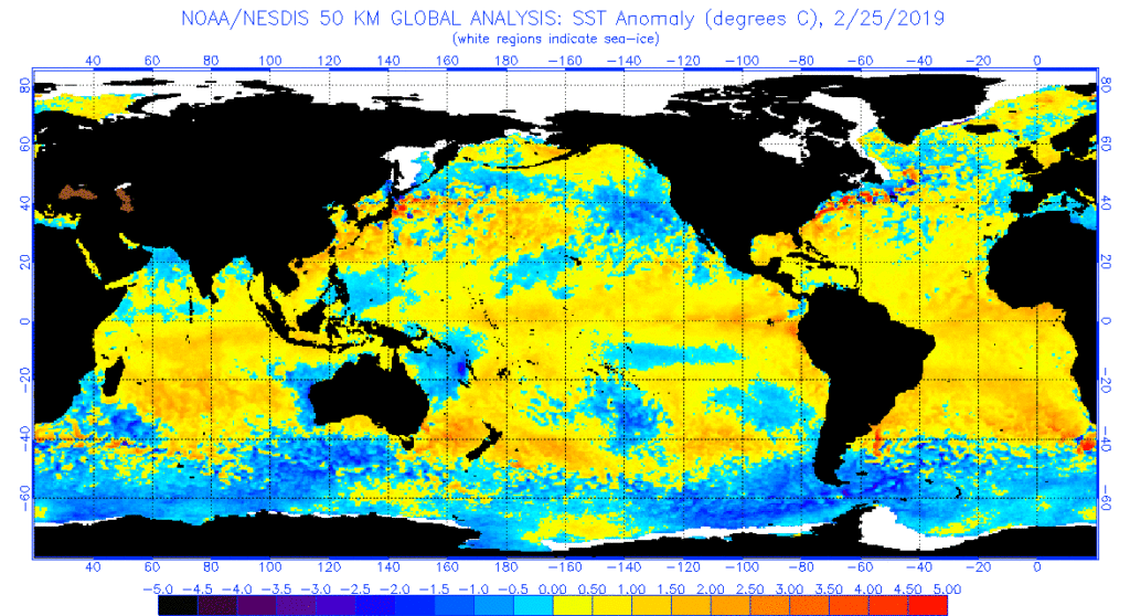
Recent AMO readings have been neutral to slightly negative in recent months, which does not provide much guidance in terms of U.S. temperature and precipitation anomalies. However, looking at the sea surface temperature anomaly map above, temperatures in the Gulf of Mexico and in the western Atlantic Ocean off the Southeast coast are running warmer than normal. This could provide the South with slightly higher levels of moisture to work with, should this air get pulled north.
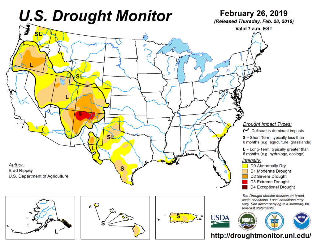
As far as drought conditions are concerned, there really isn’t too much to glean off of the current drought areas in terms of forecasting tornado activity (which some would argue is never the case). Recent drought improvements in the western U.S. over the past two months has really limited the overall coverage and severity of drought in the U.S. It’s been quite wet overall lately across the Lower 48.
Everything combined, I have come up with the following analogs that most closely resemble the pattern and what I think we could expect for this spring in terms of temperature and precipitation anomalies.
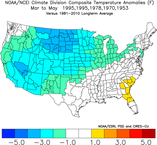
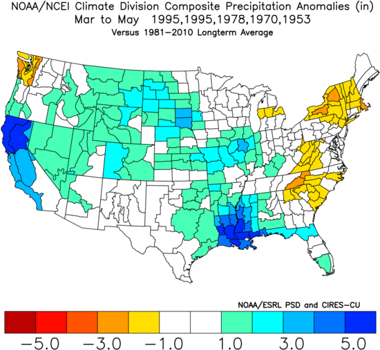
This pattern suggests that the South might be dealing with a normal to active year, though the northern parts of the country may end up quieter than normal due to the colder air, at least in the early part of the season. By May, slight cool anomalies don’t have as much of an impact.
Bottom Line
Among the four analogs, 1995 was a stand-out as the only above normal spring tornado season, thanks to a very active May that made up for the slightly quieter than normal March and April.
The remaining analogs (1978, 1970, 1953) were all quieter than normal in all 3 months, even if accounting for reporting bias.
Given how March is initially looking quieter than normal this year in combination with the analogs, I would lean toward spring 2019 ending up quieter than normal. However, as 2015 shows, there is the potential for a higher count at the close of the spring season, which is certainly possible given the analog temperature and precipitation patterns I have come up with.
Odds of the tornado count ending up below/near/above the normal off 511 tornadoes (1991-2010 average) for meteorological spring:
Below normal: 50% (less than 470 tornadoes)
Near normal: 30% (between 470 and 550 tornadoes)
Above normal: 20% (above 550 tornadoes)
Long term forecasts, while generally providing added value to climatology, are still very broad-brush outlooks and do not offer a very consistent level of skill. This forecast only hopes to capture some of the most reliable information available to provide a best guess as to what spring may bring.
Latest posts by Mark Ellinwood (see all)
- Spring 2023 seasonal tornado outlook - March 1, 2023
- Spring 2022 seasonal tornado outlook - March 1, 2022
- Spring 2021 seasonal tornado outlook - March 1, 2021
Mark, Why do you need all that fancy science and statistical analysis stuff when we’ve got Accu-Weather? They just predicted 1,075 tornadoes for 2019!
https://www.accuweather.com/en/videos/ctiztswe
Very interesting. But despite all this knowledge, they are also predicting 1,000 something tornadoes this year. Idk what to believe 🤷🏻♀️
Well, after this weekend I would say this forecast needs a revision.
It says: “Dixie Alley could face multiple tornado threats over the next two weeks.”
March averages about 75 tornadoes