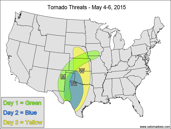
1-3 DAY
Thursday
Central High Plains — POTENTIAL: Low — CONFIDENCE: Normal
Moderate to strong shear and low to moderate CAPE will overspread the southern and central High Plains this afternoon into the overnight hours as a shortwave trough advances into eastern Colorado, providing the chance for tornadoes. However, high LCLs and/or a moderate to strong cap will strongly inhibit tornado formation.
Eastern Tennessee Valley, southern Appalachians — POTENTIAL: Very Low — CONFIDENCE: High
Storms firing in a moderate speed shear and low to moderate CAPE environment could gain some rotation, but fairly unidirectional flow and weak surface winds will keep the tornado potential to a minimum.
Friday
Central Plains — POTENTIAL: Medium — CONFIDENCE: Normal
Storms will form throughout the day along and ahead of a cold front in the vicinity of the upper-level vort. max. These storms will be in a moderate to high shear and low to moderate CAPE environment, with rotation coming easily to the storms that form. A cap will inhibit storm formation south of the risk area.
Saturday
No tornadic activity expected.
4-7 DAY
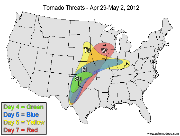
Sunday
Texas Panhandle, western Oklahoma, southern Kansas — POTENTIAL: Very Low — CONFIDENCE: Low
The GFS model shows some tornadic potential an area with low to moderate shear and low to moderate CAPE in conjunction with surface convergence zones. Poorer model agreement starts to have a bigger impact on the forecast risk and confidence at this range. The GFS has decent support from the ECMWF at this point, but the NAM is in a totally different world at the end of its forecast range.
Monday
Central and southern Plains, southern Midwest — POTENTIAL: Medium — CONFIDENCE: Normal
Stronger moisture return over a wider area will increase the confidence for tornadic potential on Monday, with storms possible along the dryline from Texas into Kansas and other storms possible near the warm front in the southern Midwest. Capping could be an issue in the southern parts of the risk area along the dryline.
Tuesday
Plains, southern Midwest — POTENTIAL: Medium — CONFIDENCE: Normal
The risk area continues to expand as the warm front lifts northward and CAPE increases throughout the warm sector. Storms are again expected to fire along the dryline and near the warm front. Widespread showers and storms in the central and northern Midwest are expected to prevent the warm front from advancing much further north from Monday.
Wednesday
Central and southern Plains, western Midwest — POTENTIAL: Low — CONFIDENCE: Low
Increased timing/placement issues between the GFS and ECMWF lowers the confidence as an upper-level vort. max moves into the northern Plains and starts to progress the large-scale trough eastward. Storms forming ahead of the developing low’s cold front will still be in an environment with the potential for tornadic activity, though at this point the advancing cold front will start to lose the low-level directional shear.
Latest posts by Mark Ellinwood (see all)
- Spring 2023 seasonal tornado outlook - March 1, 2023
- Spring 2022 seasonal tornado outlook - March 1, 2022
- Spring 2021 seasonal tornado outlook - March 1, 2021