1-3 DAY
Monday
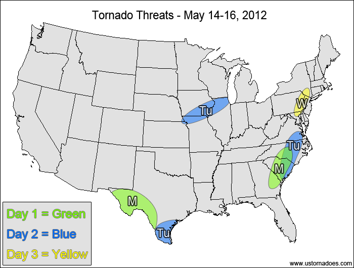
West Texas — POTENTIAL: Medium — CONFIDENCE: Normal
An upper-level low will provide the stage for tornadic development as a low CAPE and low/moderate shear environment gets a boost from upsloping to increase the tornado potential.
Eastern Southeast — POTENTIAL: Very Low — CONFIDENCE: Normal
CAPE and shear will be on the low side, but there is enough low-level rotation for stronger storms to possibly become tornadic.
Tuesday
Southern Texas — POTENTIAL: Very Low — CONFIDENCE: Normal
The tornado potential associated with the upper-level low will wane going into Tuesday, but enough dynamics will remain in the low CAPE environment for a tornado to possibly form.
Western Midwest — POTENTIAL: Low — CONFIDENCE: Normal
Storms forming ahead of a cold front could become tornadic during the mid afternoon to early evening within the low CAPE and low/moderate shear environment.
Carolinas, southeast Virginia — POTENTIAL: Very Low — CONFIDENCE: Normal
Similar to Monday’s eastern U.S. threat, wind speed shear and CAPE will be on the low side, but pockets of 2000+ J/kg CAPE are in the forecast for tomorrow, which could allow rotating storms to produce a tornado.
Wednesday
Mid-Atlantic — POTENTIAL: Very Low — CONFIDENCE: Normal
An upper-level vorticity maximum associated with a cold front could provide enough dynamical forcing for a strong storm to become tornadic if there is enough low-level rotation available.
4-7 DAY
Thursday
No tornadic activity expected.
Friday
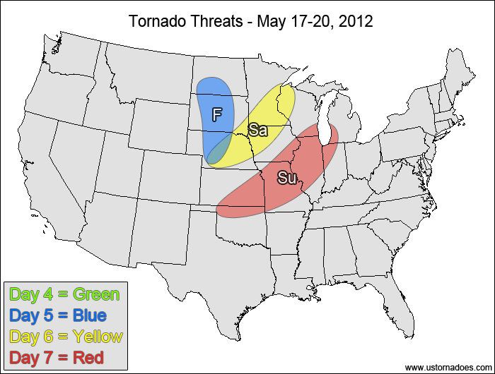
Northern Plains — POTENTIAL: Low — CONFIDENCE: Low
A disturbance will work into the northern Plains on Friday, providing some tornadic potential in a low/moderate CAPE and low shear environment. A lack of upper-level organization and high LCLs will accompany the low shear in inhibiting the tornadic potential. Disagreement between the models in the evolution of this system will keep confidence low.
Saturday
North-central U.S. — POTENTIAL: Medium — CONFIDENCE: Low
The ECMWF shows better storm coverage along a cold front compared to the GFS as the system develops and pushes eastward. If the ECMWF verifies, it would lead to a medium potential, whereas the GFS showing more of an issue with capping and wind shear would lead to a lower potential. Confidence in the location and potential is very low due to the poor model agreement.
Sunday
Central Plains, southwestern Midwest — POTENTIAL: Medium — CONFIDENCE: Low
Storms forming along and ahead of the advancing cold front could become tornadic again if enough shear is present to get storms to rotate and mature into supercells within the low/moderate CAPE environment.
Latest posts by Mark Ellinwood (see all)
- Spring 2023 seasonal tornado outlook - March 1, 2023
- Spring 2022 seasonal tornado outlook - March 1, 2022
- Spring 2021 seasonal tornado outlook - March 1, 2021