Some of the earlier concerns about this system’s limitations I had while writing Thursday’s forecast have abated since then, allowing for a greater risk for tornadoes over the next several days. The coupling of the upper-level dynamics and instability across the Mid-South and South is much stronger compared to what some of the models were showing back on Thursday, so I found it appropriate to issue a special update to discuss the higher tornado potential.
NOTE: This will be in place of the Monday update. Expect the next regular update on Thursday.
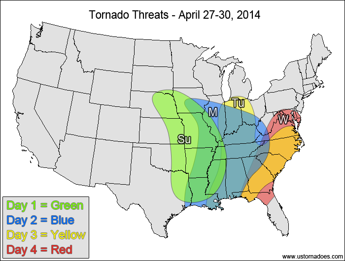
Sunday
East-central and southeastern Plains, central and southern Mississippi Valley — TORNADO RANGE: 12-36 — CONFIDENCE: Normal
Expected Tornado Hotspot: East-central Plains to mid-Mississippi Valley
Pros: Good/strong speed and directional shear in the low to mid levels, good/strong upper-level dynamics, moderate to high instability in the southern areas, low to moderate instability in the northern parts of the risk area
Cons: Backing winds in the upper levels in the northern parts of the risk area, unidirectional flow in the mid to upper levels in the central and southern parts of the risk area could allow storms to become more linear as the event evolves
Monday
Mid and southern Mississippi Valley, Ohio Valley, western Southeast — TORNADO RANGE: 10-30 — CONFIDENCE: Normal
Expected Tornado Hotspot: Mid-Mississippi Valley
Pros: Good/strong speed shear, good directional shear, strong upper-level dynamics, moderate to high instability in the southern areas, low to moderate instability in the northern areas
Cons: Backing winds in the upper levels in the northern parts of the risk area, unidirectional flow in the mid to upper levels in the central and southern parts of the risk area could allow storms to become more linear as the event evolves
Tuesday
Southern Midwest, Southeast — TORNADO RANGE: 5-15 — CONFIDENCE: Normal
Expected Tornado Hotspot: Southeast
Pros: Good/strong speed shear, decent/good directional shear, good upper-level dynamics, low to moderate instability
Cons: Possible contamination of the environment by earlier storms, storm mode becoming more linear
Wednesday
Southern Mid-Atlantic, eastern Southeast, southern Virginia — TORNADO RANGE: 3-10 — CONFIDENCE: Low
Expected Tornado Hotspot: Carolinas
Pros: Decent/good speed and directional shear, decent/good upper-level dynamics, low to moderate instability
Cons: Questionable lapse rates, possible contamination of the environment by earlier storms, mostly linear storm mode along the advancing cold front where the most organized activity is expected
Latest posts by Mark Ellinwood (see all)
- Spring 2023 seasonal tornado outlook - March 1, 2023
- Spring 2022 seasonal tornado outlook - March 1, 2022
- Spring 2021 seasonal tornado outlook - March 1, 2021