We have previously looked at the basic ingredients for tornadoes and where to find them, but no two tornado setups are identical, or have the same balance of ingredients.
Often times, there are one or more things that could inhibit tornado formation in an otherwise favorable atmosphere.
Forecast basics Identifying and understanding ingredients | Search for boundaries and gradients | Looking for what could go wrong :: Radar watching Basic tornadic signatures | Advanced tornadic signatures :: Spotting basics Tornado shapes and sizes
Despite the high number of tornadoes we get in the U.S. each year, tornadoes are very sensitive to the surrounding environment. One little detail can turn a potential tornado outbreak into a run-of-the-mill line of storms, or even a “blue sky bust.”
NOTE: This is NOT a guide to storm chasing. It is meant for forecasting purposes only. The series reflects what is needed for a typical supercell tornado, and does not necessarily match what is needed for landspouts or waterspouts.
The Cap
We keep coming back to this atmospheric cap (see the A Forcing Mechanism section to review), but it’s just that important of a feature. A cap is a section of the atmosphere where temperatures briefly increase with height, which is usually in the middle levels of the atmosphere. This cap creates a stable layer that unstable air below it has to try to break through in order to create a storm. The strength of the cap can be the difference between blue skies and a mile-wide wedge.
There are three main ways to break the cap:
- The first one is to heat and mix the lower levels of the atmosphere to the point where the heat from the surface creates enough buoyancy and momentum for a pocket of air to rise through the cap.
- The second way is to get a forcing mechanism, such as a cold front, to forcibly lift a pocket of unstable air through the cap until the air can get to a point where it can rise freely on its own.
- A common third way to erode the cap is from the top down, with an upper-level trough bringing cooler air into the capped portion of the atmosphere.
While just one of these can be sufficient to break through a weak cap, usually it takes two or all three methods to break through some of the more robust caps. Strong caps, when eroded, can yield an abundance of potential energy for storms to tap into. Breaking a strong cap can lead to some of the strongest, most violent storms this planet has to offer.
Of course, the major downside to having a strong cap is it increases your likelihood of not getting any storms, so one must adjust expectations and chances accordingly.
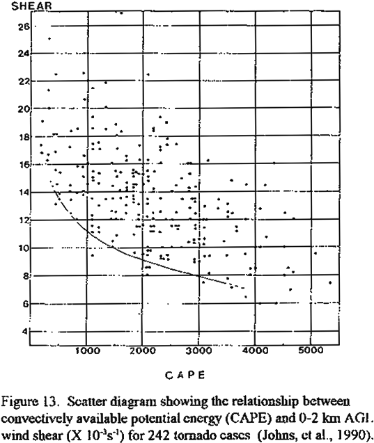
Shear/CAPE Balance
Shear is good. Convective Available Potential Energy (CAPE) is good. While you can generally always use more CAPE, shear is a different story.
Early spring is infamous for its “low CAPE/high shear” storm systems, in which storms can become strong by getting organized by the wind shear while tapping into a relatively low amount of CAPE. These are your fast-moving storms with forward motion approaching 50-70+ mph. Given the right balance between the strong shear and the CAPE, these storms can be sustained for several hours as the winds aloft keep them organized.
However, too much shear, mainly in the form of very strong winds in the mid-to-upper levels of the atmosphere, can actually rip the storms apart. The strong winds essentially blow through the storm and disrupt the storm’s updraft, killing the storm’s means of maintaining vertical growth.
Source
A storm’s vertical growth could also be stunted by a lack of shear. Without increasing winds with height, a storm will grow straight up instead of at an angle. After maturing, a storm that has grown straight up will then rain into its own updraft, causing the updraft wind to weaken or even die completely. Some increasing shear with height forces the falling rain away from the storm’s updraft, allowing the storm to maintain a constant vertical feed of unstable air.
Veer-Back-Veer Wind Profile
You have good instability, good speed shear, and a good forcing mechanism to break through the cap. Sounds like the perfect setup, right? Not always.
The dreaded veer-back-veer profile can be subtle in some cases and obvious in others. In any instance, having this wind profile can greatly hinder tornado development.
So what is a veer-back-veer wind profile? Winds that turn clockwise as you go up through the atmosphere are said to have a “veering” profile, whereas winds that turn counter-clockwise with increasing height are said to be “backing.” Winds that veer with height are good. Veering winds help create the spin in updrafts, which can then lead to mesocyclones, rotating wall clouds, and perhaps tornadoes.
Backing winds create spin in the opposite direction, disrupting the nice, circular flow created by the veering winds. Think of it as stirring your coffee in one direction, then taking your spoon and swirling it back in the opposite direction. Your nice coffee funnel has suddenly turned into a turbulent mess.
Source
The “veer-back-veer” nomenclature is as simple as you think it is. Winds start veering in the lower level of the atmosphere, then they start to back in the mid-levels before veering again in the upper-levels. This wind profile can turn an otherwise ideal setup into a mess of broken clusters and lines of storms that lack any sort of organized rotation.
Front Undercutting
A tornado is a circulation that descends from the cloud and makes contact with the ground. This requires the winds to be able to mix down to the surface, which generally means that there needs to be warm, moist air underneath the storm’s area of rotation. If cool, stable air works in underneath the storm, the circulation will have a much more difficult time reaching the ground. In addition, the storm could suck up this cooler air, which would weaken the updraft and could even kill the storm completely.
Progressive low pressure systems give forecasters and chasers a mixed bag of feelings. On one hand, the forcing that the systems produce can help generate storms. However, a fast-moving cold front associated with these low pressure systems can outpace the forward motion of the storms as they form. In these cases, the cold front is said to be “undercutting” the storm by bringing in cool, stable air under the bottom of the storm. When this happens, the storm typically becomes “elevated,” in which the energy the storm is pulling is coming from the air aloft rather than from the air near the surface. While elevated storms can persist for hours, the cool, more stable air below the storms greatly inhibit the storm from producing a tornado.
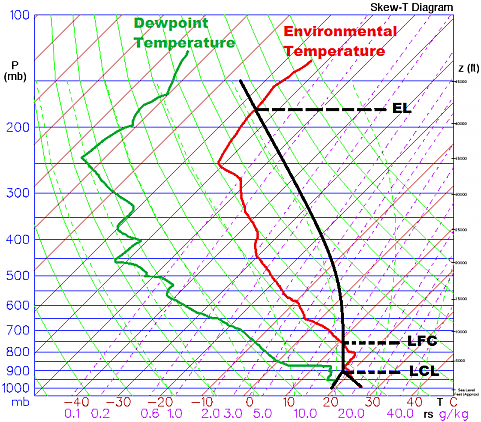
High LCLs
The Lifted Condensation Level (LCL) is the level of the atmosphere where moist, rising air will start to condense into a cloud. The LCL height is essentially how high up the base of the cloud is from the ground.
Rotating wind within the storm needs to work down through the air between the cloud base and the ground to become a tornado. The lower the cloud base is, the easier it is for the storm’s circulation to reach the ground.
Source
As wind and daytime heating mixes the lower levels of the atmosphere, moisture near the surface is mixed up into the atmosphere, allowing the low-levels to dry out. This can be seen in areas where the dew point depression (mentioned in part 1) increases as the day goes on. Drier air in the low-levels causes the LCL to be higher, which in turn creates a longer distance for a storm’s circulation to travel before it can make contact with the ground and become a tornado. High LCLs can be overcome with stronger rotation, but LCLs above 1250-1500m can greatly reduce the odds of tornado formation. LCLs under 1000m are the most ideal.
—
And that is the end of my three part series on what to look for when forecasting tornadoes.
If you want even more details on tornado forecasting, Rich Thompson’s lecture series about how to forecast tornadoes is quite excellent. While I focused on the basics of each area, his lecture series is a concise overview of all processes involved.
Latest posts by Mark Ellinwood (see all)
- Spring 2023 seasonal tornado outlook - March 1, 2023
- Spring 2022 seasonal tornado outlook - March 1, 2022
- Spring 2021 seasonal tornado outlook - March 1, 2021
Thanks for the lesson. It would be helpful to do a case analysis – applying to setups on recent outbreaks. I’m interested in learning how to identify key numbers for choosing a target area for the day. Really appreciate your blog!
Quick correction but in the LCL discussion, I think you mean 1250-1500 meters and 1000 meters rather than feet.
Yes… definitely meters. Thanks for catching that.
Excellent read though. I particularly like the veer-back-veer explanation, which wasn’t completely covered in the OU/Thompson lectures from what I saw.