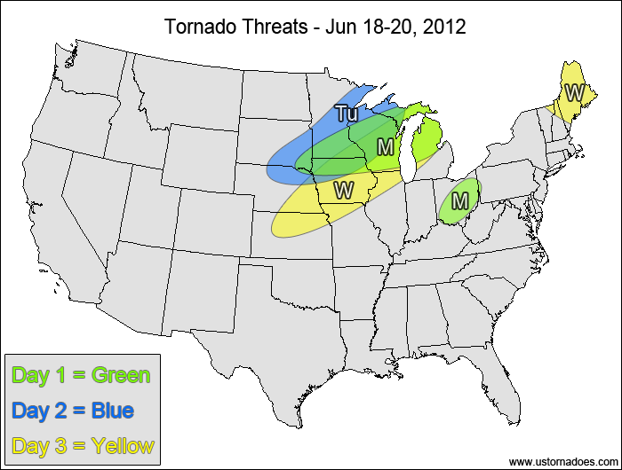
1-3 DAY
Northern Midwest — POTENTIAL: Medium — CONFIDENCE: High
Moderate shear overlapping moderate instability will produce an environment that is somewhat favorable for tornadoes. The biggest concern will be storm mode, as clusters and lined-out storm modes appear more likely than discrete supercells, which will work against the overall potential.
Ohio Valley — POTENTIAL: Low — CONFIDENCE: Normal
A cluster of severe storms will be moving through an environment with moderate CAPE and favorable low-level shear this afternoon and evening, but mid and upper-level speed shear is fairly weak, which will greatly inhibit potential tornadic activity.
Tuesday
South Dakota, Nebraska, western Midwest — POTENTIAL: Medium — CONFIDENCE: Normal
Moderate CAPE and moderate to high shear will set up the basics for good tornado potential, but storms are forecast to quickly line-out ahead of an advancing cold front, and the GFS points to potential capping issues.
Wednesday
Central Plains, Midwest — POTENTIAL: Low — CONFIDENCE: Normal
Storms forming ahead of a cold front in a moderate CAPE environment will have moderate low to mid level speed shear to work with, but mostly-unidirectional flow and weak upper-level winds will keep most storms fairly linear, limiting the tornado potential.
Northern New England — POTENTIAL: Very Low — CONFIDENCE: Normal
Storms that could potentially form along a frontal boundary will have moderate to strong northwesterly flow aloft, which coupled with westerly winds at this surface and low to moderate CAPE could provide a small risk for tornadoes.
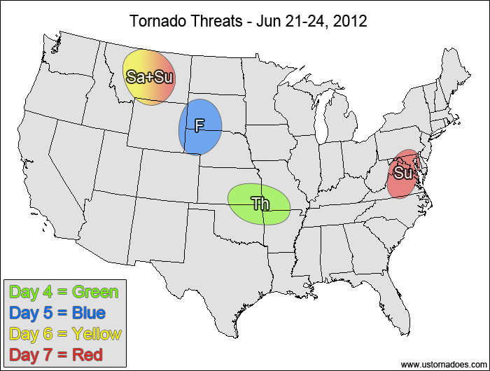
4-7 DAY
Central Plains, southwestern Midwest — POTENTIAL: Low — CONFIDENCE: Normal
Storms forming in a moderate CAPE and low shear environment will have enough directional shear to possibly become tornadic if storms can mature enough.
Friday
Northern and central High Plains — POTENTIAL: Low — CONFIDENCE: Normal
A shortwave trough ejecting into the north-central U.S. could trigger tornadic storms in a moderate CAPE and low/moderate shear environment, but high LCLs, height rises and potential low-level moisture issues will inhibit tornadic development.
Saturday
Montana— POTENTIAL: Low — CONFIDENCE: Low
Low to moderate CAPE and moderate to high shear ahead of the main upper-level trough provides a favorable environment for tornadoes, but a lack of storm coverage could keep the overall potential number of tornadoes down.
Sunday
Montana— POTENTIAL: Low — CONFIDENCE: Low
See Saturday’s discussion.
Mid-Atlantic — POTENTIAL: Low — CONFIDENCE: Low
A developing disturbance will provide some directional shear in a low to moderate CAPE environment, but given the anticipated weak speed shear it could be difficult for tornadic storms to develop.
Latest posts by Mark Ellinwood (see all)
- Spring 2023 seasonal tornado outlook - March 1, 2023
- Spring 2022 seasonal tornado outlook - March 1, 2022
- Spring 2021 seasonal tornado outlook - March 1, 2021


