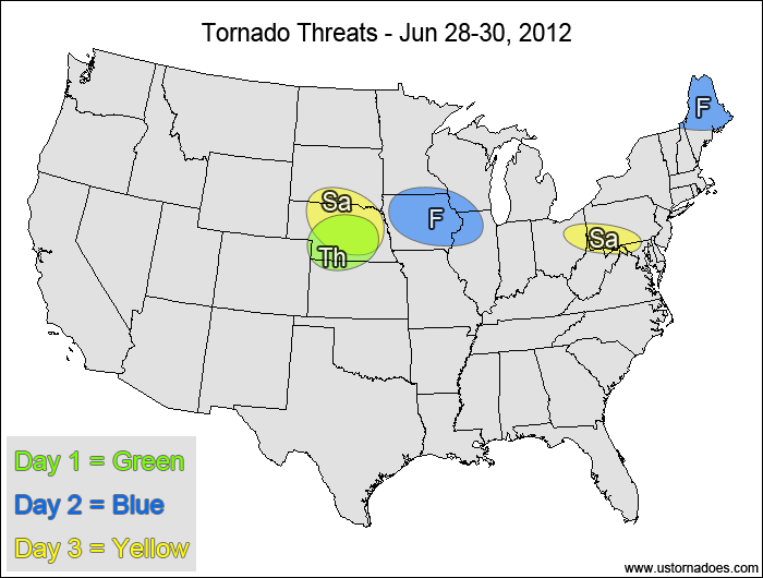
1-3 DAY
Thursday
Central Plains, western Midwest — POTENTIAL: High — CONFIDENCE: Normal
Storms forming ahead of a cold front will have moderate to high amounts of instability to play with, along with moderate to strong shear in the northern parts of the risk area. Despite cloud cover currently over the northern parts of the risk area, return flow should be sufficient enough to bring the tornado risk up north to the border as the cold front advances into the western Midwest. Should the warm front stay south, the tornado potential will be more limited. Further south in the central Plains, weaker shear will keep the tornado potential very limited despite high instability.
Friday
Northern and central Plains, western Midwest — POTENTIAL: Medium — CONFIDENCE: Normal
A new disturbance developing in the High Plains will allow for moisture to surge back northward, with strong southeasterly flow in the low-levels. Weak shear aloft will keep the tornado potential limited in the southern and central areas, with weaker instability limiting the tornado potential across the northern High Plains. Capping issues and slightly backed winds in the upper-levels may also inhibit the tornado potential in the southern parts of the risk area. Tornadoes will also be possible along the weakening cold front from the previous system.
Saturday
Central Plains, western Midwest — POTENTIAL: Medium — CONFIDENCE: Normal
Storms will form along and ahead of the second main disturbance’s cold front, keeping the tornado potential alive thanks to low-level directional shear and moderate CAPE. However, weakening upper-level shear will limit the tornado chances throughout the risk area, and backed winds aloft will hinder tornado development in the central Plains.
4-7 DAY
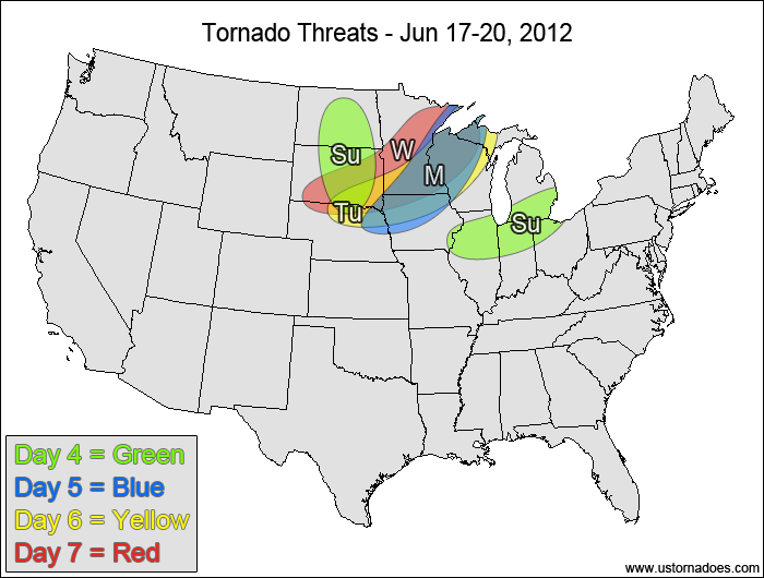
Sunday
Northern Plains — POTENTIAL: Medium — CONFIDENCE: Normal
Model disagreement becomes quite noticeable at this range between the NAM and the GFS/ECMWF. The overall instability and shear will be questionable Sunday, with ample CAPE and moderate shear on the GFS and more anemic values via the NAM. There is enough agreement between the GFS and ECMWF with respect to the storm coverage and evolution to keep confidence near normal.
Southern Great Lakes — POTENTIAL: Very Low — CONFIDENCE: Normal
An advancing cold front provides the focus for storm initiation in the southern Great Lakes, with low to moderate CAPE and fairly weak shear allowing for a minimal tornado potential.
Monday
Western Midwest — POTENTIAL: Medium — CONFIDENCE: Normal
Moderate CAPE and moderate shear ahead of a frontal boundary will keep the tornado potential alive in the western Midwest on Monday. Capping issues and weaker low-level directional shear will inhibit the overall threat.
Tuesday
Northern Plains, western Midwest — POTENTIAL: Low — CONFIDENCE: Low
Storms firing along a frontal boundary will be in a low to moderate CAPE and moderate shear environment, but the tornado potential will be limited by weak low-level lapse rates and weak low-level directional shear.
Wednesday
Northern Plains, northwestern Midwest — POTENTIAL: High — CONFIDENCE: Low
Model disagreement will preclude higher confidence in the forecast, but an upper-level trough advancing into the northern Plains is expected to trigger another round of storms on Wednesday. This system has the potential for a high tornado risk if it pans out the way it is currently depicted on the models, with moderate CAPE, moderate shear and good low-level directional shear.
Latest posts by Mark Ellinwood (see all)
- Spring 2023 seasonal tornado outlook - March 1, 2023
- Spring 2022 seasonal tornado outlook - March 1, 2022
- Spring 2021 seasonal tornado outlook - March 1, 2021