UPDATE: Thursday 4/11 – Due to a vehicle emergency, Mark will not be able to create a new threat forecast this Thursday. An updated product will likely be created Friday or Saturday.
The tornado threat forecast is back to updating on a regular schedule (every Monday and Thursday except when I’m on vacation). We’re starting off here with a storm system that looked more promising last week than it does now, but it’s still got some umph to it and will bear watching as it slides from the Plains to the East Coast.
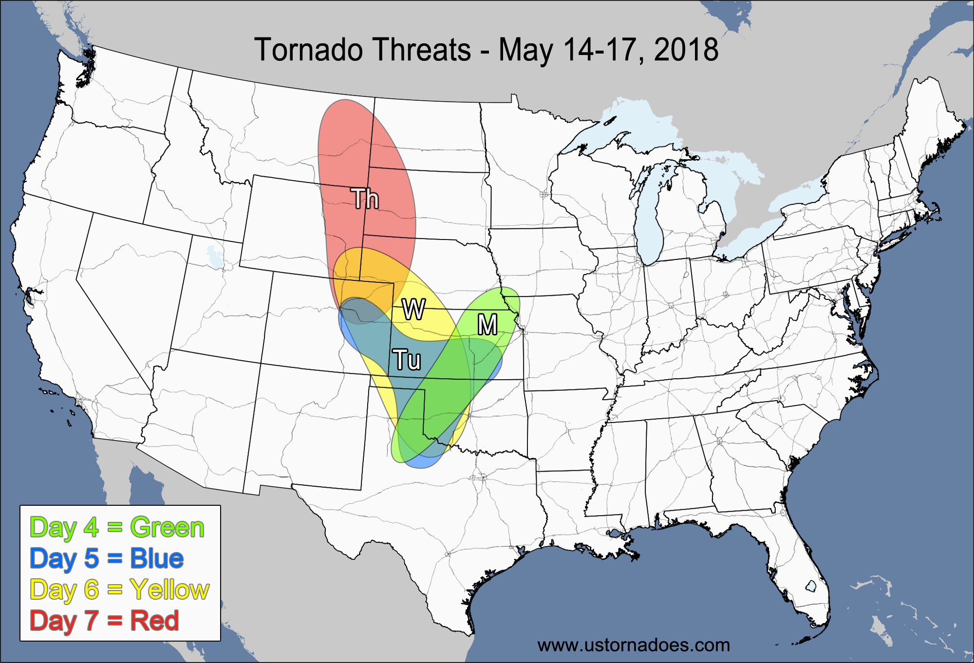
1-3 DAY
Monday
Central Plains — POTENTIAL: Medium — CONFIDENCE: Low
A strong cap will likely inhibit storm formation across OK and much of KS, with the main area of concern being eastern CO and far western KS where the capping will be weaker and the forcing stronger. Moisture and instability start to notably decrease once you start to work into CO, but with good upsloping with winds out of the southeast, any storm that does form will be favorable for rotation and could produce a tornado or two. Hi-res models have indicated that at least one or two isolated supercells could/are likely to form in eastern CO in the late afternoon or early evening hours.
Tuesday
Central and southern Plains, southwestern Midwest — POTENTIAL: High — CONFIDENCE: Normal
The main area of upper-level energy will work its way into the Plains tomorrow, which will allow the surface low to strengthen and migrate eastward across the central Plains. While the dynamics will be in much better position compared to Monday, the directional shear will be more modest as the flow in the mid and upper levels gains more of a southerly component. Right now, the most favored area stretches from eastern OK into southeastern KS and MO as the surface low helps back the surface winds more in this region. While a few tornadoes are expected, storm formation could get messy and could become linear quickly, which pose risks to the low side.
Wednesday
Southern Midwest, ArkLaTex, western Southeast — POTENTIAL: Medium — CONFIDENCE: Normal
Most confident part of the forecast will be along the cold front as embedded supercells try to spawn tornadoes within the possible QLCS. Some pre-frontal activity is possible in the Southeast, but the mid-level lapse rates look pretty weak as you get away from the cold front.
4-7 DAY
Thursday
Tennessee Valley, Southeast — POTENTIAL: Low — CONFIDENCE: Normal
Lower instability and less directional shear will keep the tornado potential to a minimum, but embedded supercells are still possible along the cold front.
Friday
Eastern Carolinas, southeastern VA — POTENTIAL: Low — CONFIDENCE: Low
There is considerable model disagreement with the timing of the cold front on Friday, with the GFS bringing the front offshore Friday morning while the slower Euro/NAM solutions would favor a slower front. Both models have been fairly stubborn with their respective timing, which keeps the forecast confidence low. One of the reasons for the slower frontal passage on the European model is the development of a secondary low over NC/VA, which could also create a more favorable wind field for tornadic development. However, low instability, cloud cover concerns and the timing discrepancies will keep the overall potential on the low side.
Saturday
No tornadic activity expected.
Sunday
Eastern Iowa, northern Missouri, Illinois — POTENTIAL: Low — CONFIDENCE: Low
A disturbance developing over the north-central U.S. could provide enough dynamics in conjunction with weak instability to produce a tornado or two.
Latest posts by Mark Ellinwood (see all)
- Spring 2023 seasonal tornado outlook - March 1, 2023
- Spring 2022 seasonal tornado outlook - March 1, 2022
- Spring 2021 seasonal tornado outlook - March 1, 2021
Still thinking a lower risk for tornadoes today? How about in St Louis? Even though I’m toasty warm in DC with our quick warm up, I’ve got family there and looks like they may be in a potential spot today.
Today underperformed overall it seems. Powerful front.. too powerful.