Risks will be fairly low through early next week until a new upper-level trough swings into the Plains and eastern U.S. in the middle to later part of next week.
1-3 DAY
Friday
Southern Mid-Atlantic — POTENTIAL: Very Low — CONFIDENCE: Normal
Some instability and shear is present over the southern Mid-Atlantic ahead of a cold front, and there is enough of each for a chance for a tornado. Despite the growing instability, mostly unidirectional shear and mid-level capping will work against tornadic development.
Saturday
No tornadic activity expected.
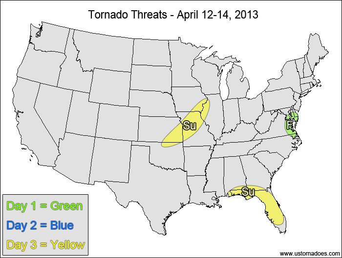
Sunday
Southwestern Midwest — POTENTIAL: Low — CONFIDENCE: Normal
Surface moisture will be modest at best with dewpoints forecast to be in the 50s, but strong forcing ahead of a cold front should produce a line of storms, and some of these storms could get enough rotation to put down a tornado or two.
Eastern Gulf Coast — POTENTIAL: Low — CONFIDENCE: Normal
An upper-level disturbance will trigger storms across the Southeast, with Florida and the eastern Gulf Coast possibly getting enough instability to allow for a low tornado threat as the disturbance passes through the region.
4-7 DAY
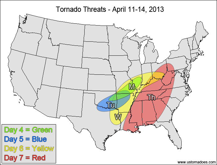
Monday
Central Mississippi Valley — POTENTIAL: Low — CONFIDENCE: Low
Pattern progression starts to differ enough to lower confidence from here on out. The cold front is expected to stall out on Monday, providing a boundary for storms to fire off of. A capped warm sector will prevent storm formation in the warm sector, but any storms that may form there will have low to moderate instability and enough directional shear to possibly become tornadic.
Tuesday
Oklahoma, Arkansas, northern Texas — POTENTIAL: Medium — CONFIDENCE: Low
Better storm coverage and improving wind shear bumps up the overall potential for Tuesday, though capping in the warm sector and no appreciable upper-level forcing are expected to keep the potential limited.
Wednesday
Southern Midwest, southern Mississippi Valley — POTENTIAL: Medium — CONFIDENCE: Low
An upper-level trough will progress eastward into the Plains and will develop a surface low and increase forcing on Wednesday. While significant spatial discrepancies appear on the models, a larger area of storm potential, moderate instability and height falls over the western parts of the risk area will allow for at least a medium potential. Risks for Wednesday’s tornado potential are more to the upside than downside.
Thursday
Ohio Valley, Southeast — POTENTIAL: Medium — CONFIDENCE: Low
There is low confidence in the location of the risk area as the trough progresses eastward. A line of storms is forecast to develop along the cold front, with the wind field becoming more unidirectional in the warm sector. The lack of directional shear will work against tornadic development, keeping the forecast potential limited to medium.
Latest posts by Mark Ellinwood (see all)
- Spring 2023 seasonal tornado outlook - March 1, 2023
- Spring 2022 seasonal tornado outlook - March 1, 2022
- Spring 2021 seasonal tornado outlook - March 1, 2021
Should I be worried about Johnson City, TN’s tornado risk this week? It’s in Extreme NE TN. I have a awful fear of tornadoes.
Probably not too much. Main risk should be south/southwest.
Thank you for the response. Sounds great!
I’m in DFW, is the tornado risk going to be serious on Wednesday?