1-3 DAY
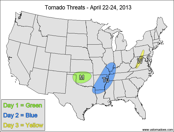
Monday
Oklahoma, far southern Kansas — POTENTIAL: Low — CONFIDENCE: High
Storms that develop in the warm sector along/ahead of a cold front will have low to moderate CAPE and plenty of directional shear, but weak low-level speed shear and poor storm coverage in the warm sector will keep the overall potential limited.
Tuesday
Central Mississippi Valley — POTENTIAL: Low — CONFIDENCE: Normal
Storms forming along a cold front could gain rotation and become tornadic, but CAPE will generally be low, with a cap inhibiting storm strength in the southern areas. The area with the best potential is in the northern end of the risk area where capping is not a concern, with strong shear but very low CAPE.
Wednesday
Central Appalachians — POTENTIAL: Very Low — CONFIDENCE: Normal
A ribbon of low CAPE along the cold front could provide enough fuel for embedded supercells, but with mostly unidirectional flow, storms will likely need orographic enhancement of the low-level winds to become tornadic.
4-7 DAY
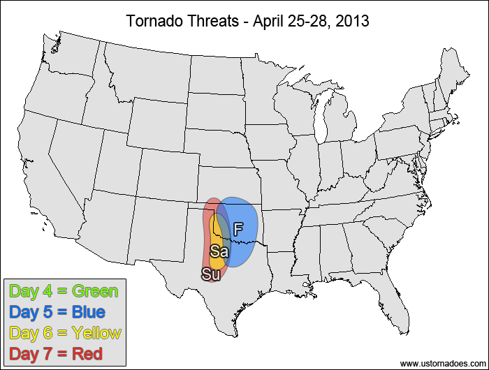
Thursday
No tornadic activity expected.
Friday
Southern Plains — POTENTIAL: Low — CONFIDENCE: Normal
A weak shortwave that will push across the Plains will trigger mostly elevated showers and storms, but an area of surface-based convection may develop, which in conjunction with low to moderate CAPE and good low-level directional shear could potentially produce a tornado or two.
Saturday
Western Oklahoma, north-central Texas — POTENTIAL: Very Low — CONFIDENCE: Low
The GFS tries to develop dryline convection in an environment with moderate to high CAPE and low to moderate shear, but poor model agreement in the storm coverage will keep the confidence and overall potential very low.
Sunday
Western Oklahoma, north-central Texas — POTENTIAL: Low — CONFIDENCE: Low
A more widespread warm sector and greater storm coverage on the GFS again suggests another possible dryline setup, but this day has the same caveats as Saturday in terms of fairly weak speed shear and poor model agreement.
Latest posts by Mark Ellinwood (see all)
- Spring 2023 seasonal tornado outlook - March 1, 2023
- Spring 2022 seasonal tornado outlook - March 1, 2022
- Spring 2021 seasonal tornado outlook - March 1, 2021