Aaaand we’re back, and we brought the (somewhat) quieter weather back with us!
1-3 DAY
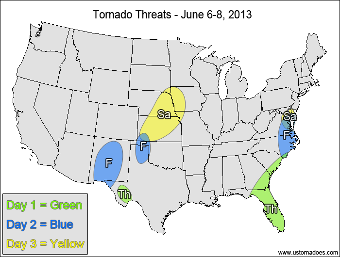
Thursday
Eastern Southeast — POTENTIAL: Medium — CONFIDENCE: Normal
Tropical Storm Andrea will make its way into the eastern Southeast today into tonight, with a chance for tornadoes in its northeast quadrant with favorable shear and low CAPE.
West Texas — POTENTIAL: Very Low — CONFIDENCE: Normal
Storms that form within the risk area will have decent directional shear, but will be missing appreciable speed shear and will have initially-high LCLs, which will keep the tornado potential limited.
Friday
Southeastern Mid-Atlantic, eastern NC — POTENTIAL: Medium — CONFIDENCE: Normal
The tornado threat with T.S. Andrea will shift up the East Coast tomorrow as it progresses north, with less activity expected with it compared to what we have seen and will continue to see today.
New Mexico, TX/OK Panhandles — POTENTIAL: Low — CONFIDENCE: Normal
A weak shortwave disturbance will help trigger storms in these areas, but weak speed shear and some areas of high LCLs will again hinder much of the potential.
Saturday
Central Plains — POTENTIAL: Medium — CONFIDENCE: Normal
A more notable upper-level disturbance will provide good shear for tornadoes in an environment with low to moderate CAPE, but height rises and a weak/strung-out surface low will work against a more organized threat.
Southern Mid-Atlantic — POTENTIAL: Low — CONFIDENCE: Low
A small disturbance currently over Texas may hold together and move in behind T.S. Andrea on Saturday, providing favorable shear in a localized area with low CAPE that could produce a tornado or two if such a setup comes to fruition. Given uncertainties in the evolution of both this energy and T.S. Andrea, confidence is low.
4-7 DAY
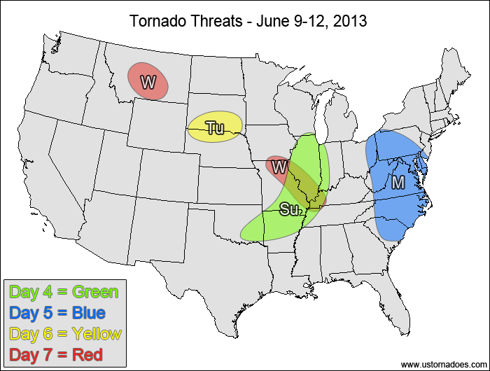
Sunday
Southwestern Midwest — POTENTIAL: Medium — CONFIDENCE: Low
As the upper-level trough progresses eastward, confidence starts to fade due to diverging model solutions. Enough directional shear remains in place with an area of moderate CAPE for tornadic storm(s) to form.
Monday
Mid-Atlantic, Carolinas — POTENTIAL: Low — CONFIDENCE: Low
Enough directional shear may exist ahead of the progressive disturbance that tornadoes could be possible again with this system.
Tuesday
South Dakota, northern Nebraska — POTENTIAL: Low — CONFIDENCE: Low
An upper-level disturbance working across the top of a ridge could trigger storms in the warm sector that could tap into moderate to high CAPE and could become tornadic. Overall storm coverage in the warm sector is questionable at this range as some capping sits over much of the warm sector.
Wednesday
Montana — POTENTIAL: Very Low — CONFIDENCE: Low
A disturbance moving across the Northwest could trigger storms in Montana that will be capable of rotation and could perhaps put down a tornado.
Southwestern Midwest — POTENTIAL: Low — CONFIDENCE: Low
Warm sector storm coverage is questionable again with this disturbance as it progresses eastward, with enough directional shear remaining to keep at least some threat for tornadoes around the region.
Latest posts by Mark Ellinwood (see all)
- Spring 2023 seasonal tornado outlook - March 1, 2023
- Spring 2022 seasonal tornado outlook - March 1, 2022
- Spring 2021 seasonal tornado outlook - March 1, 2021