UPDATE 6/14: Sorry folks, but I’ve been too busy to get the second forecast done this week. Next Monday will be iffy as well since I have plans for that afternoon, but I should be good to write one on Tuesday.
—–
The “I had too many other things to do yesterday” version. Also, if I go chasing on Thursday, that forecast will get delayed until Friday.
1-3 DAY
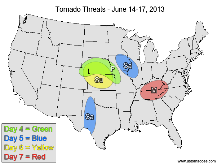
Tuesday
Northern Plains — POTENTIAL: Medium — CONFIDENCE: Normal
Storms that can get rooted to the surface will have good directional shear overlapping with moderate instability, which will result in rotating storms, a few of which may become tornadic.
Southern New England — POTENTIAL: Very Low — CONFIDENCE: High
Good directional shear and adequate speed shear may be enough to create rotating storms capable of producing a tornado within a confined area of low instability.
Wednesday
Montana — POTENTIAL: Low — CONFIDENCE: High
Height falls associated with an approaching upper-level trough will help initiate storms in Montana. High LCLs should limit most tornadic activity, but with plenty of shear and low to moderate CAPE, a tornado or two are still possible.
Southern Midwest, central Mid-Atlantic — POTENTIAL: Medium — CONFIDENCE: Normal
Storms forming within the risk area will generally have moderate to high instability and good speed shear to work with, but with questionable low-level directional shear and a tendency for storms to line out (along with a likely MCS), the window of opportunity for tornadic storms may be small.
Thursday
Montana — POTENTIAL: Medium — CONFIDENCE: Normal
Similar setup to Wednesday, but with somewhat better moisture and instability that allowed for an increase in the potential.
Northeastern Colorado, southwestern Nebraska — POTENTIAL: Very Low — CONFIDENCE: Normal
Storms triggered by upslope forcing in an area with low instability may rotate and could possibly put down a tornado.
East-central Mid-Atlantic — POTENTIAL: Medium — CONFIDENCE: Low
Model disagreement in the timing of a progression of a disturbance will keep confidence low for now, but if the slower solutions verify, a tornado threat exists just south and east of a surface low where moderate CAPE and shear is present. The greatest – and perhaps only – risk will be along the warm front that will probably be place across southeastern Pennsylvania and into either southern New Jersey or Delaware.
4-7 DAY
Friday
Central Plains — POTENTIAL: Low — CONFIDENCE: Normal
A shortwave-induced surface low and its associated warm front will help trigger storms in the central Plains, with questionable coverage and intensity of the storms keeping the overall potential low despite areas of moderate to high instability.
Saturday
Western Texas — POTENTIAL: Low — CONFIDENCE: Normal
Storms firing along a dryline will be in an environment with moderate instability and favorable directional shear, but a lack of speed shear behind the shortwave will keep the tornado potential limited.
Western Midwest — POTENTIAL: Low — CONFIDENCE: Low
A mess of storms is expected in the Midwest, with a warm front that will enhance low-level rotation in the risk area and could give storms enough rotation to produce a tornado or two.
Sunday
Central Plains — POTENTIAL: Medium — CONFIDENCE: Normal
Moderate to high instability associated with steep mid-level lapse rates in conjunction with good directional shear will provide a good environment for rotating storms, though weak low- and mid-level speed shear will limit the overall potential.
Monday
Tennessee Valley — POTENTIAL: Low — CONFIDENCE: Low
An advancing disturbance will trigger widespread rain and storms over the Midwest and Tennessee Valley, with enough low-level rotation in the Tennessee Valley that mature storms could gain enough rotation to produce a tornado or two.
Latest posts by Mark Ellinwood (see all)
- Spring 2023 seasonal tornado outlook - March 1, 2023
- Spring 2022 seasonal tornado outlook - March 1, 2022
- Spring 2021 seasonal tornado outlook - March 1, 2021