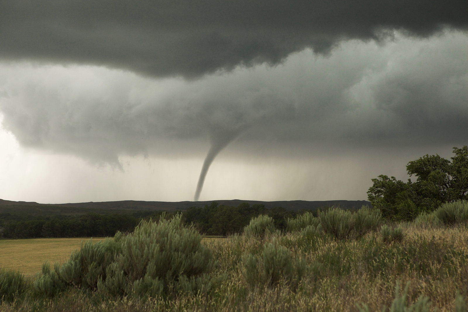
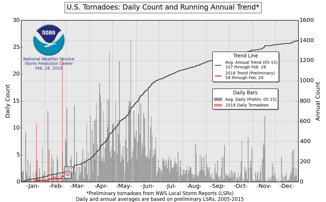
Despite the tornadoes that occurred on February 24, including the first deadly tornadoes of the year, the United States is running behind schedule in the tornado numbers department this year. Will the quiet trend we have seen thus far continue as we head into March, April, and May?
The country just went through a major pattern change, with a more persistent parade of storms digging into the Southwest before strengthening over the central United States. Meanwhile, a strong blocking pattern in the western Atlantic (-NAO) is allowing the parade of storm systems to drop cold fronts deep into the South. This limits the flow of warm, moist air from the Gulf of Mexico into the country.
While the pattern over the western half of the country could be conducive to a more active tornado regime, the blocking pattern over the Atlantic and eastern U.S. is keeping the overall instability low across the U.S. by shutting down the transport of warm, moist Gulf of Mexico air into the U.S. This will probably help limit tornado production over at least the next 1-2 weeks.
Given how strong and long-lasting the blocking appears to remain over the eastern U.S. in the near-to-medium term, it will likely be hard to come by many tornadoes in at least the first half of March due to the limited instability. However, given the favorable atmospheric setup over the western and central U.S., there could be several “high shear, low CAPE” setups where favorable wind shear can overcome the limited instability and still produce tornadoes. We’ll call it a wash and go with a near normal tornado count for March.
Going farther out into April and May, the more predictable El Niño-Southern Oscillation (ENSO), Pacific Decadal Oscillation (PDO), and Atlantic Multidecadal Oscillation (AMO) indices provide a better look at how things might work out for the remainder two-thirds of spring.
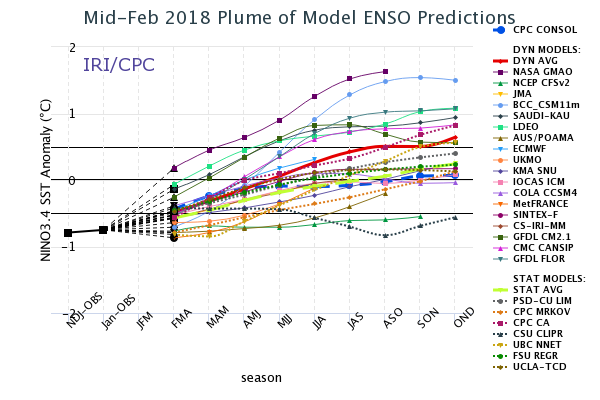
Most of February gave us a true feel for a (borderline) moderate La Niña, but the closing days brought about significant changes over the Northern Hemisphere that brought the U.S. that will last into at least a good part of March. As the extreme blocking pattern relaxes, will La Niña make a grand return to be the main driver of April and May weather?
The La Niña provides a decent background state of the atmosphere, but we need more than that to make a forecast! Let’s take a look at the PDO and AMO.
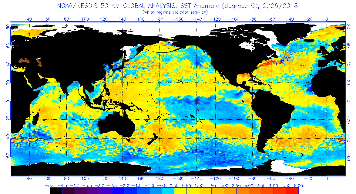
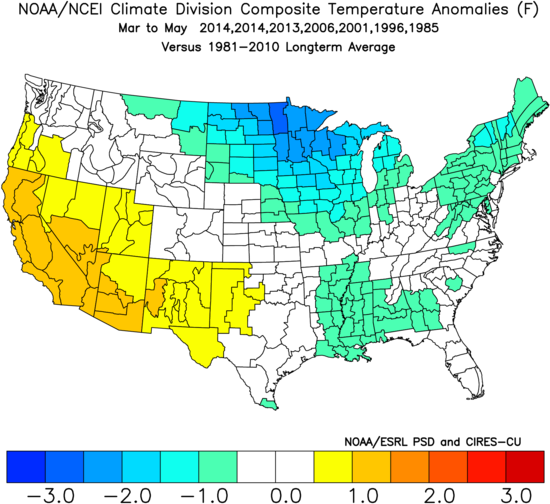
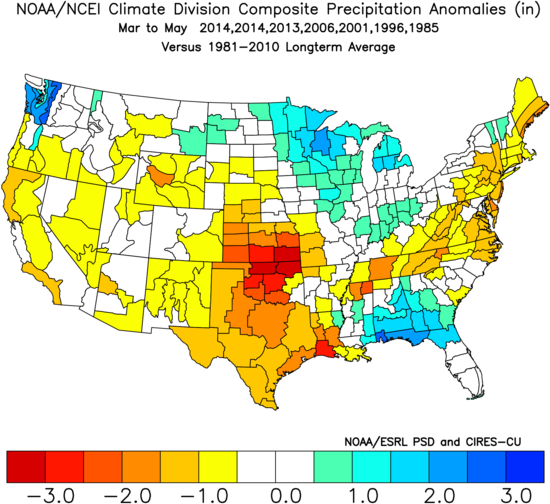
The AMO is fairly positive at the moment, which can be seen in the yellows, oranges and reds in the Gulf of Mexico and the western and central Atlantic in the image above. The PDO was somewhat positive through most of winter, which helped cause California to be drier than normal. However, the past couple of weeks have dropped sea surface temperatures along the West Coast as seen by the more prominent blue (cooler) anomalies along the West Coast, indicating that the PDO is becoming more neutral.
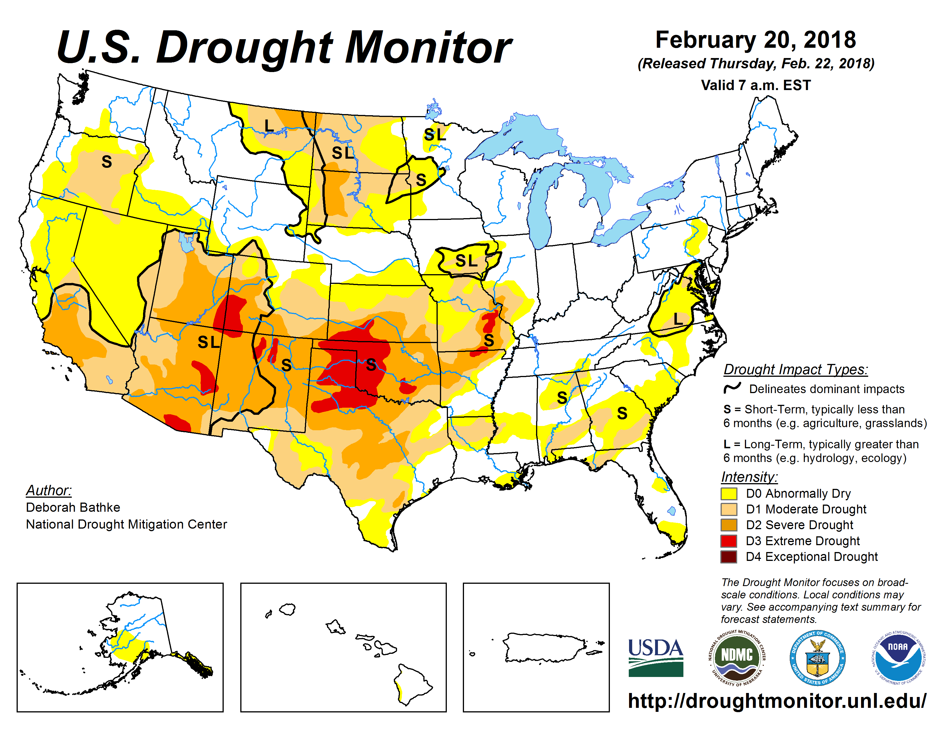
Checking in on the current drought conditions across the country, there are notable drought conditions in the Southwest and much of the Plains.
Drought can help create warmer and drier than normal conditions, which brings about greater dew point depressions at the surface, and thus higher cloud bases. The higher the cloud base, the harder it is for a circulation to reach the ground to become a tornado. While not as extreme as the drought in 2014, the current drought does cover much of the same region. The drought helped contribute to 2014’s below normal spring tornado count.
So what do we get with a borderline moderate La Niña, a positive AMO, and drought conditions in the Southwest?
Weighing the current conditions and analogs based on several long-range predictors, here is a look at the potential overall pattern from March through May:
The pattern above generally favors a more active tornado pattern in the Mississippi Valley and the Southeast, while the more classic chase territory of the central and southern Plains could certainly end up quieter than normal.
Bottom line…
While most March and April analogs favored a quieter than normal conditions, 2006 was a notably active exception. Heading into May, the tornado count was normal to below normal. Given how I am expecting a nearer-normal March, I will bring up the overall count a bit from what the analogs show. April has the potential for higher than normal tornado activity, but whatever gains that might occur in April could get wiped out by a quieter than normal May.
So what’s to stop this from being a more explosive year like 2008 or 2011? One major factor is the PDO, which although seems to be trending more neutral at the moment, has generally been positive in recent months. The PDO was firmly negative in 2008 and 2001 throughout the winter and spring months, which allowed storms to take a more favorable path across the southern U.S. instead of having to drop in from the Northwest like many storms in a +PDO regime do. However, if we do end up with a more persistent -PNA pattern that allows more storms to dig into the Southwest and brings more Gulf moisture into the central and eastern U.S., late March through May could become a more prolific tornado producer.
Odds of the tornado count ending up below/near/above the normal off 511 tornadoes (1991-2010 average) for meteorological spring:
Below normal: 35% (less than 460 tornadoes)
Near normal: 50% (between 460 and 550 tornadoes)
Above normal: 15% (above 550 tornadoes)
Long term forecasts, while generally providing added value to climatology, are still very broad-brush outlooks and do not offer a very consistent level of skill. This forecast only hopes to capture some of the most reliable information available to provide a best guess as to what spring may bring.
Latest posts by Mark Ellinwood (see all)
- Spring 2023 seasonal tornado outlook - March 1, 2023
- Spring 2022 seasonal tornado outlook - March 1, 2022
- Spring 2021 seasonal tornado outlook - March 1, 2021
Thanks for the analysis. PDO is not particularly strong at the moment and anybody’s guess where its headed. Would be great if you could follow PDO with a refined forecast into May. Question: Any correlation between AMO or PDO and if not, which exerts greater influence on weather in the Plains?
So, what this means is if we go down an -pna pattern we get a greater tornado season but if not then mississippi valley/southeast will get most of the tornadoes? P.S. I live in the southeast
As a storm spotter, I really enjoyed reading that. I am also a truck driver and my being a spotter will help me stay safe out here and hopefully others.
Does this mean the west coast might be seeing some tornadoes? I have never seen a tornado before because I live in California.
Brian, Central Valley has 2 short lived seasons (Sept-Nov. and Feb-April.) for 1-5 tornadoes / year. Baby stuff compared to the Plains but fun for us weather geeks.
Fun needle in the haystack chasing!
Living in the Wichita Kansas area, this is always my favorite time of year. I am 45 years old and what I have observed over the years is if we typically have a wet march with snow and the temps stay low we have a active season. It also helps have plenty of snowfall in the Rockies so that air coming in is super cold. Then mix with that super moist warm gulf. Good times. It’s been very dry here the last few months so I am praying for moisture soon. Believe it or not, it also matters how well the wheat yields are in the fields. If yields are big and can hold a lot of moisture, you get fuel down at ground levels.
I haven’t saw a tornado before, I have seen a funnel forming, but not the actually tornado, hopefully I can see one soon!
Be careful what you wish for… if you happen to be at home when your wish comes true, you just might have to kiss your home goodbye.
You dont want to see one, they are very scary and if you have lalossafobia, I’m not sure if that is the right way to spell it, which is fear of storms/tornados, you could even faint or vomit an amazing amount..so trust me, no you do not..