1-3 DAY
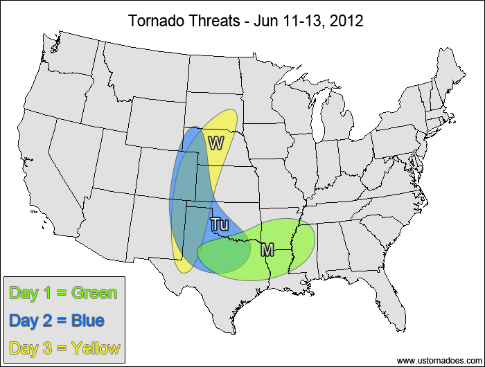
Monday
Southern Plains, lower Mississippi Valley — POTENTIAL: Low — CONFIDENCE: Normal
In the eastern half of the risk area… clusters of storms and one or more MCSes will contribute a low tornadic threat today, with the potential for embedded supercells. Further west, storms forming near a stalled frontal boundary could become tornadic in a moderate to high CAPE environment. A lack of speed shear will limit the overall tornado potential.
Tuesday
Central High Plains, southern Plains — POTENTIAL: Medium — CONFIDENCE: Normal
Storms forming in the upslope areas of the central and southern High Plains and additional storms along a stalled frontal boundary will allow for a medium tornado potential, with the greatest potential across the High Plains as instability increases in an area with moderate shear.
Wednesday
Central Plains, southern High Plains — POTENTIAL: Medium — CONFIDENCE: Normal
Instability will increase in the Plains as a dryline gets better defined ahead of a shortwave trough, allowing for some tornado potential. Directional wind shear will remain favorable for tornado development, but low wind speeds in the mid and upper-levels will inhibit the overall potential.
4-7 DAY
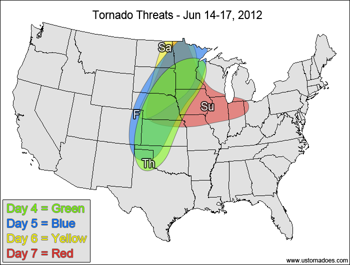
Thursday
Northern and central Plains, western Midwest — POTENTIAL: Medium — CONFIDENCE: Normal
Moderate to high instability and low speed shear will allow for tornadic storms once again Thursday, but the overall potential will be limited as the strongest shear sits behind the cold front that will work through the northern Plains.
Friday
Northern and central Plains, western Midwest — POTENTIAL: Medium — CONFIDENCE: Normal
A similar setup to Thursday will be in place on Friday as another shortwave works into the central Plains and the main low pressure center sits over south-central Canada.
Saturday
Northern Plains, northwestern Midwest — POTENTIAL: Medium — CONFIDENCE: Low
There is a significant difference in the progression of the upper-level trough heading into Saturday, with the GFS keeping the trough back in the northern Rockies as the ECMWF ejects the trough into south-central Canada. Regardless, moderate to high CAPE will still be in place, allowing for some tornado potential despite wind shear remaining on the weak side.
Sunday
Northern and central Plains, Midwest — POTENTIAL: Low — CONFIDENCE: Very Low
Confidence in the forecast becomes very low by Sunday due to uncertainties in the storm progression, with the GFS continuing to hold energy back in the Plains as the ECMWF progresses the main trough further east into the eastern Midwest and Ontario. The moderate CAPE and low shear setup remains in place, though low-level directional shear may be waning at this point in the forecast.
Latest posts by Mark Ellinwood (see all)
- Spring 2023 seasonal tornado outlook - March 1, 2023
- Spring 2022 seasonal tornado outlook - March 1, 2022
- Spring 2021 seasonal tornado outlook - March 1, 2021