1-3 DAY
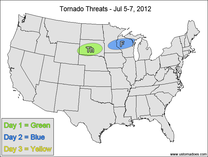
Thursday
South Dakota, northeast Wyoming — POTENTIAL: Low — CONFIDENCE: High
A stalled frontal boundary will help trigger storms in a moderate CAPE and low shear environment. Initially high LCLs and weak upper-level support will keep the tornado threat fairly minimal despite good directional shear and instability.
Friday
Northwestern Midwest — POTENTIAL: Very Low — CONFIDENCE: High
Moderate CAPE will be wedged up against a stalled frontal boundary again on Friday, but with speed shear remaining fairly weak and directional shear weakening, the potential for tornadic storms is very low.
Saturday
No tornadic activity expected.
4-7 DAY
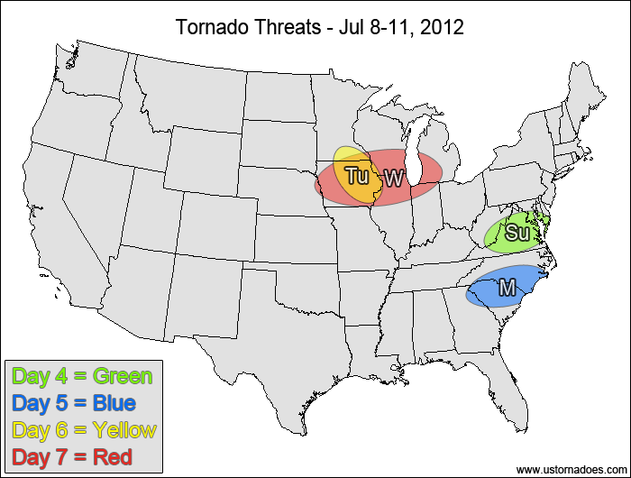
Sunday
Southern Mid-Atlantic — POTENTIAL: Very Low — CONFIDENCE: Normal
Moderate to high CAPE ahead of a cold front will be in an environment with weak shear, but there may be enough low-level rotation for a brief tornado within the risk area.
Monday
Carolinas — POTENTIAL: Very Low — CONFIDENCE: Normal
The setup will be similar to Sunday, with speed shear remaining very weak, which will be the main inhibitor to the tornado potential.
Tuesday
Location — POTENTIAL: Very Low — CONFIDENCE: Normal
Low to moderate shear, moderate CAPE and some low-level directional shear in a northwest-flow regime could allow for a tornadic storm to form.
Wednesday
West-central Midwest — POTENTIAL: Low — CONFIDENCE: Low
A short-wave disturbance working into the northern Midwest will bring moderate shear into an environment with moderate CAPE. This could allow for a more organized severe threat, with enough rotation present for a low tornado threat.
Latest posts by Mark Ellinwood (see all)
- Spring 2023 seasonal tornado outlook - March 1, 2023
- Spring 2022 seasonal tornado outlook - March 1, 2022
- Spring 2021 seasonal tornado outlook - March 1, 2021