This is the first of a three part series that covers the basics on how to forecast tornadoes. In this post I’ll concentrate on the general necessary ingredients needed for a tornado to form.
Forecast basics Identifying and understanding ingredients | Search for boundaries and gradients | Looking for what could go wrong :: Radar watching Basic tornadic signatures | Advanced tornadic signatures :: Spotting basics Tornado shapes and sizes
Part two will examine the surface and low-level features in the horizontal layers (mostly meaning boundaries), and part three will discuss what you can look for that might hurt tornado development.
NOTE: This is NOT a guide to storm chasing. It is meant for forecasting purposes only. The series reflects what is needed for a typical supercell tornado, and does not necessarily match what is needed for landspouts or waterspouts.
Wind Shear
Wind shear creates spin. Tornadoes spin. So naturally, you want more wind shear to create more spin. However, there are a lot of subtleties to how the wind changes with height that can drastically alter how favorable a setup is for producing tornadoes.
In the most general sense, you want wind speeds to increase with height, and you want them to veer — change direction — with height. Veering in the northern hemisphere means the wind direction moves clockwise (i.e. south to west to north) as you gain altitude. Wind shear helps shape a thunderstorm’s updraft and gives it rotation. It is the most critical ingredient to creating a tornadic supercell.
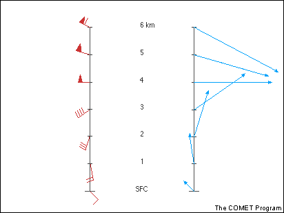
Above is an example of a veering wind profile. The vectors on the right help visualize the direction (the way it’s pointing) and speed (length of the arrow) of the wind as you gain altitude. The wind barbs on the left are generally easier to read and understand once you know how to decipher them. The UCAR RAP site has a handy page for learning how to decode wind barbs.
How much wind shear — the change in both speed and direction — needed for tornadoes depends on our second most important ingredient…
Instability
What allows clouds to grow to tens of thousands of feet high in the first place? Instability. How do you create instability? By decreasing the temperature as you gain altitude. Instability measures the amount of potential energy (CAPE) a storm can utilize. Greater instability allows for stronger storms.
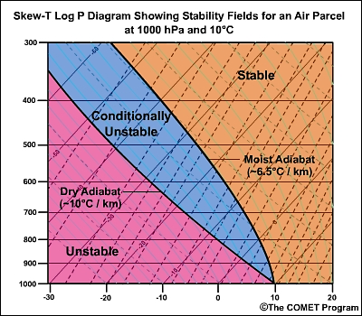
How quickly the temperature cools with height is the main driver behind how much instability is present. The atmosphere is considered stable when the rate of change in the temperature as you gain altitude (i.e. the lapse rate) is less than 6.5 C/km (which is the moist adiabatic lapse rate). When the atmosphere is stable, clouds are not able to freely grow upward. If the lapse rate is right at 6.5 C/km, the atmosphere is considered conditionally unstable, in which a forcing mechanism (covered below) can create the initial lift needed for clouds to grow vertically. Once the lapse rate is greater than 6.5 C/km, clouds (i.e. moist air) are able to grow vertically on their own, with no forcing mechanism needed.
The greater the lapse rate, the more instability you have and the faster a cloud can grow vertically. Generally, lapse rates will max out around 9.8 C/km, which is known as the dry adiabatic lapse rate (Note: Some people use 10 C/km as the dry adiabatic lapse rate… it depends on who you ask). However, there are some instances in which the atmosphere can generate slightly higher lapse rates of greater than 10 C/km. This can be achieved by very strong heating at the surface, or by quickly bringing in very cold air aloft.
Above is a sounding, which is used to track the change in temperature (amongst other variables) with height.
You can check out the first eight pages of this PDF to get some basics of how to read soundings. I also put together a basic introduction on my personal site. Soundings can tell you just about all you need to know about the atmosphere at any given point, and they are an important tool when trying to forecast tornadoes.
Instability also depends on how much moisture is in the atmosphere. The higher the dew point is at the surface and/or in the low-levels of the atmosphere, the greater the instability can potentially be. Moisture in the mid and upper levels of the atmosphere is also important, as higher amounts of moisture aloft tends to decrease the lapse rates and instability.
Heat and Moisture
These two ingredients go hand-in-hand as critical components mainly in the low-levels of the atmosphere. While a wide array of surface temperatures and dew points can produce tornadoes, you want the surface to be as warm and moist as possible without a large dew point depression (the difference between the temperature and the dew point). A greater dew point depression generally leads to a higher cloud base (the distance from the Earth’s surface to the bottom of the cloud), and a higher cloud base makes it harder for a tornadic circulation to reach the ground.
For most elevations (generally below a few thousand feet), you typically want the dew point to be at least 60 degrees, with the dew point depression under 20 degrees. Once you start getting above a few thousand feet and into the mountains or High Plains, you can get away with lower dew points in the 50s, especially if the surface temperature is also cooler to help minimize the dew point depression.
A Forcing Mechanism
What is a forcing mechanism? It is a feature that forces the air to rise in some way or another. A front is a very common forcing mechanism. When a front (cold/warm/occluded/stationary/etc.) moves horizontally, or when air moves over a front, the air will be forced up over the front. In the right environment, a front can give moist air the upward momentum it needs to grow into a storm.
Other kinds of boundaries, which are simply areas that have a notable change in some atmospheric variable (wind direction, dew point, etc.), can also serve as starting points for storm activity. Fronts and boundaries will be covered more in part two.
Forcing mechanisms are usually needed when there is a “cap” in the atmosphere. A cap is simply a layer of stable air in an otherwise unstable environment that prevents vertical cloud growth. Caps are found in the low-to-mid levels of the atmosphere, usually between 850-700 mb. Most caps that exist prior to tornadic storms are in the form of a shallow temperature inversion, in which the temperature actually increases as you gain altitude instead of cooling.
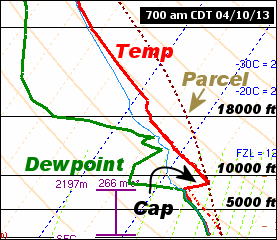
The above graphic is an example of a capped sounding. The cap is denoted by the temperature rapidly increasing, then decreasing as you go up through the atmosphere. You can check out this site to learn more about how to identify an atmospheric cap.
Thunderstorms have a love/hate relationship with caps. A cap will help prevent the formation of extensive cloud cover and rain that typically forms in a moist environment when no cap is present. The cap allows the atmosphere to store more and more energy through the daytime hours that can be utilized in short, explosive storm growth later in the day. However, if the cap is too strong, it could prevent any air from breaking through, and no storms will form.
Air bubbling up from the surface can sometimes gain enough upward momentum to break through the cap on its own in the afternoon or early evening. Other times, the rising air needs a forcing mechanism to help it bust through the cap. Either way, you almost always want a cap in place before storm formation to help maximize the storm strength and tornadic potential.
That’s it for the basic ingredients!
Look for part two around the start of February.
Latest posts by Mark Ellinwood (see all)
- Spring 2023 seasonal tornado outlook - March 1, 2023
- Spring 2022 seasonal tornado outlook - March 1, 2022
- Spring 2021 seasonal tornado outlook - March 1, 2021
Looking forward to the rest of the series! It’s nice to see this information in such a plain-english format. Definitely going to share this site & info with the EOC I volunteer with to help explain things to our Storm Spotters that might want a little more info to go with their training.
Excellent posted link to my BLOG as well as adding this series to my weatherroom… Looking forward to the rest of the series.
For years I had read and heard that there were 8 ingredients needed for tornadoes to form, then 4. I wish there was more of a general consensus as to the exact number and process. Thank you.
great post!